
Kanyakumari
Kanyakumari
Kanyakumari (கன்னியாகுமரி) | |
|---|---|
town | |
| Government | |
| • District Collector | Dr. Rajendra Ratnu, I. A. S. |
| Population (2001) | |
| • Total | 19,678 |
Kanyakumari (Tamil: கன்னியாகுமரி) is a town in the state of Tamilnadu in India. It is also sometimes referred to as Cape Comorin. Located at the southernmost tip of the Indian Peninsula, it is the geographical end of the Indian mainland. The district in Tamilnadu where the town is located is called Kanyakumari District. The closest major cities are Nagercoil, the administrative headquarters of Kanyakumari District, (22 km) and Thiruvananthapuram, the capital of Kerala (85 km).
The town is a popular tourist place in India.
Recorded History
Kanyakumari takes its name from the Kumari Amman or Kanyakumari Temple, situated in the town, on the sea-shore, the very confluence of the three water-bodies - the Arabian Sea, the Bay of Bengal[1] and the Indian Ocean. In his work on ancient India, Ptolemy had identified Kanyakumari (Cape Comorin) along with the Gulf of Mannar as a center for pearl fishery. He also identifies Korkai, a place to the east of Kanyakumari as an emporium of pearl trade, also Travancore Census 1931 says that Paravars ruled that Coast and built the temple for their reverence to Sea Goddess.[2]
Myths and legends
There are multiple myths revolving around this place:
- According to Hindu legend, Kanya Devi, an avatar of Parvati, was to marry Siva, but as he failed to show up on his wedding day, the rice and other grains meant for the wedding feast remained uncooked and remain unused thereafter. As the legend goes, the uncooked grains turned into stones as time went by. Some believe that the small stones which look like rice on the shore today, are indeed grains of the wedding that was never solemnized. Kanya Devi is now considered a virgin goddess who blesses pilgrims and tourists who flock the town.
- According to another Hindu legend, Lord Hanuman dropped a piece of earth as he was carrying a mountain with his life-saving herb, Mrita Sanjivani from the Himalayas to Lanka (Sri Lanka) during the Rama-Ravana war. This chunk of earth is called Marunthuvazh Malai, which is literally translated to "hills where medicine lives".This is said to be the reason for the abundance of unique native medicinal plants in the area. Marunthuvazh Malai is located near Kottaram about 7 km from Kanyakumari town on the Kanyakumari-Nagercoil highway.
- The sage Agasthya, who was himself an expert in medicinal herbs, is believed to have lived around this site in ancient days. The reason why, some believe, so many medicinal herbs are to be found on these hills near Kanyakumari. There is even a village by the name Agastheeswaram close to the town, named after the sage. Today, there is a small Ashram on the middle of the Maruthuvazh Malai hill, which tourists visit (after a short trek from the base of the hill), both to visit the Ashram and also to take a glimpse of the sea near Kanyakumari a few kilometres away, and the greenery below.

Modern History
Kanyakumari has been a great centre for art and religion for centuries. It was also an area of great trade and commerce. It was ruled by the Cholas, the Cheras, the Pandyas and the Nayaks. The architectural beauty of the temples in the area are the works of these rulers. Later Kanyakumari became part of the Venad kingdom with its capital at Padmanabhapuram. The king of Venad, Anizham Thirunal Marthanda Varma, established Travancore by extending his domain further north up to Azhva, during his reign from 1729 to 1758. By this, the present Kanyakumari District came to be known as Southern Travancore. In 1741, Maharaja Marthanda Varma defeated the Dutch East India Company at the famous Battle of Colachel.
Kanyakumari was under the rule of the Paravar Kings till the downfall of Pandyas, and later by kings of Travancore under the overall suzerainty of the British until 1947, when India became independent. Travancore joined the independent Indian Union in 1947. The reign of the Travancore royals came to an end.
Under Travancore rule, the town, and the modern administrative district that bears its name, Kanyakumari District, progressed both socially and economically. Still a significant part of population study and speak Malayalam as their mother-tongue. The culture followed by Kanyakumari people is mixed and has more influence from Travancore.
In 1949, Kanyakumari became part of the reconstituted Travancore-Cochin State. Around this time, a popular agitation for the amalgamation of Kanyakumari District with Tamil Nadu by the Tamil-speaking people of the district intensified, under the leadership of Marshal Nesamony
Kumari Thanthai Marshal Nesamony was instrumental in the merger of Kanyakumari district with Tamil Nadu in 1956 during the linguistic reorganisation of states. Kanyakumari was integrated with Tamil Nadu (then known as Madras State) as per the language-based reorganisation of States.
Christianity arrived in South India around AD 52 through St. Thomas, one of the twelve Apostles of Christ. However, European missionaries, who arrived in the 16th century, propagated Christianity in the area. St. Francis Xavier (April 7, 1506 – December 2, 1552) was the pioneer in preaching Christianity in the present day Kanyakumari district. Islam is believed to have entered the southern part of India through Kanyakumari during the early part of the eighth century AD through traders and missionaries who came through sea-routes. Islam, Christianity and Jainism have also contributed to the architectural wealth and literary heritage of the region.
Geographical Location

Kanniyakumari is located at 8°05′N 77°34′E / 8.08°N 77.57°E.[3] It has an average elevation of 0 metres (0 feet). It lies at the meeting point of three bodies of water: the Arabian Sea, the Gulf of Mannar and the Indian Ocean.[4] It is situated at 8° 4′ 41″ N, 77° 32′ 28″ E, and is the terminating point of the Western Ghats and Eastern Ghats. On the north and the east, it is bounded by Tirunelveli District, while on the west and northwest it is bounded by Kerala state.
It is suggested that there once existed a continent called Kumari Kandam to the south of Kanyakumari, often compared with Lemuria.
The Town

As of 2001[update] India census,[5] Kanyakumari town had a native population of 19,678.
Kanyakumari is the southernmost town of the Indian mainland. The land mass in and around the town are hilly and uneven, with many commercial buildings and hotels at the upper crest of the land mass with the sea visible below. The old areas of the town, where the natives live, are on the lower side. Many of the natives are into fishing activity and other maritime professions.
Tourism is one of the main activities of the town ; and many locals are employed in shell-craft and other tourism-related businesses.
It is the only district in India which has a 99% literacy rate, a 98.5% female literacy rate. 60% or more are college degree holders.
Tourism

Beginning the early part of the 1970s, tourism has been an important activity in the town. Today, it is one small town in South India where one can see different languages of India spoken at different street corners, among the tourists and traders. Of late, Tourism is increasingly being promoted in the district also, apart from the town, with several beautiful natural landscapes, historic and religious places found around the district.
A total of 1.9 million tourists (domestic and foreign) visited Kanyakumari in 2007.[6]
With tourism also picking up in neighbouring Kerala, the future prospects for the growth of tourism looks bright both in Kanyakumari town and the district.
Though there are several places of tourist-interest in the town and district, Kanyakumari is especially popular in India for its spectacular and unique sunrise and sunset. The confluence of three ocean bodies - the Bay of Bengal, the Indian Ocean, and the Arabian Sea - makes the sunrise and sunset even more special. On balmy, full-moon evenings, (locally called Chitra Pournami) one can also see the moon-rise and sunset at the same time - on either side of the horizon.
Tourist Sites within the Town


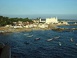
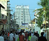
The Kumari Amman or the Kanyakumari Temple, located on the shore, is a Shakti Peetha dedicated to a manifestation of Parvati, the virgin goddess who did penance to obtain Lord Shiva's hand in marriage. The temple and the adjoining ghat, situated overlooking the shore, attract tourists from all over the world. The sparkling diamond nose-ring of the deity is said to be visible even from the sea.

On two rocky islets just off the shore, southeast of the Kumari Amman temple, are the Vivekananda Rock Memorial, built in 1970, and the gigantic 133 feet (40.5 m) tall statue of Tamil saint-poet Thiruvalluvar (Completed on January 1, 2000 by the legandary Dr. V. Ganapati Sthapati, Chennai) is one of the biggest statues in Asia. One of the rocks called Sri Padhaparai is said to bear the footprints of the virgin goddess. Swami Vivekananda is said to have meditated on this rock for three days. Also on this rock, there is a Dhyana mandapam, an area for meditation. Ferry services are available to reach the memorial.
The Gandhi Memorial has been built on the spot where the urn containing the Mahatma's ashes was kept for public viewing before immersion. Resembling central Indian Hindu temples in form, the memorial was designed in such a way that on Mahatma Gandhi's birthday, 2 October, the first rays of the sun fall on the exact place where his ashes were kept.
Photo Gallery : Kanyakumari and Around
- Kanyakumari and Places Around
-
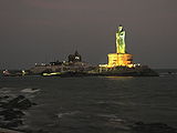 The 133 ft Thiruvalluvar Statue, Kanyakumari at night
 -
 Vivekananda Rock Memorial, Kanyakumari, at sunrise
 -
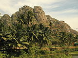
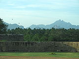 View of the Western Ghats from Vattakottai Fort
 -
 Padmanabhapuram Palace, near Thuckalay
 -
 Muttom fishing village
 -
 Scenic view at Thottiyodu, on the Nagercoil-Trivandrum Highway
 -
-
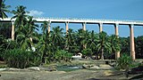
 Side view of Mathur Aqueduct,
 -
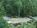 Jungle stream at Keeriparai
 -
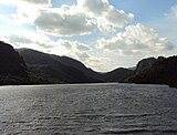
 Pechiparai Dam, with the Western Ghats in the background
 -
 Hilly ravine-like terrain near the Muttom coast
 -
 Maruthuvazhmalai (or medicinal) Hill, near Kanyakumari. Legend has it that God Hanuman dropped the hill while flying to Lanka to save sita.
 -
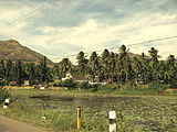 Village scene, near Kanyakumari
 -
 View of the sea from Vattakottai Fort.
 -
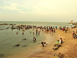 Pilgrims taking holy dip at Kanyakumari, where the Bay of Bengal, Arabian Sea and Indian Ocean, meet
 -

-
 Black sands at a beach near Vattakottai Fort
 -
 Vattaparai, near Keeriparai
 -
 Lighthouse at Muttom, which is more than 100 years old
 -
 Gandhi Mandapam, Kanyakumari, at night
 -
 Kovalam fishing village, near Kanyakumari
 -
 Thirparappu waterfalls
 -
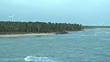
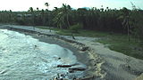
 Muttom Coast
 -
 Thirparappu waterfalls
 -
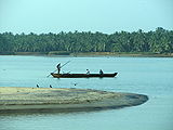 Thengapattinam Estuary
 -
 View of the Hills from Udayagiri Fort
 -
 Captain De Lannoy's Tomb at Udayagiri Fort
 -
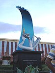 Tsunami Memorial
 -
 Rubber Plantation near Pechiparai
 -
 Nagaraja Temple, Nagercoil
 -
 St. Francis Xavier's Church, Kottar, Nagercoil - where St.Francis Xavier, the great missionary said mass in the 16th century
 -
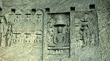
 Ancient Jain temple on hill at Chitharal, near Marthandam
 -
 Suchindrum Temple near Nagercoil
 -
 Thirparappu Temple, near Thirparappu Waterfalls
 -
 Adhi Kesava Temple at Thiruvattar. The inner temple is believed to be more than 2000 years old.
 -
-


.jpg)


.JPG)


Tourist Information
The state-owned Poompuhar Shipping Corporation runs ferry services between the town and the Vivekananda Rock Memorial and Thiruvalluvar statue, situated on rocky islets off the coast.
Kanyakumari is directly connected by rail with almost all metropolitan cities in India.
Nearest Airport is Thiruvananthapuram International Airport, 90 km away from Kanyakumari Town and 70 km from Nagercoil.kanyakumari is 850 km away from chennai
Tourist Attractions in Kanyakumari District

While Kanyakumari town has tourist attractions of its own, the district has many more, from centuries-old historic and religious sites to scenic places. The district is also rich in flora and fauna. A unique feature of Kanyakumari district is that it has all kinds of natural eco-systems. Thus, one can see beaches, mountain valleys, evergreen forests in the deep interior, rubber and clove plantations on the highlands, etc. - all in a 50 km radius of Nagercoil, the administrative headquarters of Kanyakumari District. Nagercoil is 22 km from Kanyakumari town. (see Kanyakumari District for more on the district).
The following are some of the many popular tourist attractions around Kanyakumari -


- Our lady of Ransom Church situated in Kanyakumari,the place where the missionaries had preached the paravas and converted them to christianity.The first church in the form of a thatched roof was built here in the early 15th century for venerating Santhosha Madha .The church at present stands 153 m tall and it was 100 years old.The new church was built in Gothic Architecture and it looks fabulous when seen with the seashore background, viewing from Our Lady of Ransom Arch near Church Road entrance.
From the shore where the fishing boats are moored you can see the three towering spires of this off-white Gothic structure with a distinct Portuguese feel. The Church of Our Lady of Ransom is a more than 100-year-old building dedicated to Mother Mary. But what catches your eye first-up is the 153-foot-high (46 meters) central tower crowned with a Cross of pure gold. Truly a beautiful structure; the church looks particularly gorgeous against the molten-blue noon sky. Astonishingly, the grand Gothic façade is a striking contrast to its almost bare interiors.
Once you tread in you will be goggled by its hollowness; no pews anywhere in sight, only a beautiful idol of Mother Mary clad in a sari – like in most South Indian churches – and a little Cross on the altar. This emptiness is further accentuated by colorful light patterns thrown by the stained-glass windows on the bare floor. And one is given to wonder that the church is probably no longer functional! On the contrary, in fact, the church holds mass regularly on the floor made of sand. Since the parish here predominantly comprise local fishing folks, mass is always held in the regional language Tamil.
- Vattakottai Fort (literally, "circular fort") is an 18th-century fort overlooking the sea, located six kilometres from Kanyakumari. The small historic fort also gives an enchanting view of the sea around and the hills on the other side.
- Suchindram has the Sthanumalayan temple with a repository of art treasures belonging to several kingdoms. The temple is famous for its ninth-century inscriptions, musical columns, and 6-meter-tall statue of the monkey god Hanuman. The main deity in the form of a shivlinga represents Shiva, Vishnu, and Brahma, the trinity of the Hindu pantheon.
- The Panchappathi, five primary sacred places of Ayyavazhi are all situated within a fifteen-kilometre radius of Kanyakumari. It also includes the Swamithope Pathi (headquarters of Ayyavazhi), a famous temple in Tamilnadu, situated ten kilometres to the northwest. It is not structurally massive temple, but is known for its non-idolatry system of worship.
- Nagercoil has the St. Francis Xavier's church at Kottar, where the missionary, St. Francis Xavier resided when he did his missionary work in the nearby areas. In Nagercoil, there is also the Nagaraja Temple, and shrines dedicated to Lord Shiva and Vishnu. The entrance to this temple is reminiscent of the Chinese architecture of a Buddhist Vihar.
- Padmanabhapuram Palace is a large 17th century palace of the Travancore kings, made almost entirely of wood - the only one of its kind in India.
- Udayagiri Fort, built by King Marthanda Varma, has a foundry for casting guns. It is also the tomb-site of the king's trusted European general Captain De Lennoy. Udayagiri Fort is now a bio-diversity park, administered by the Department of Forests, Kanyakumari Division.
- Mathur Hanging Trough, near Thiruvattar in the District, is an aqueduct that carries irrigation water through a canal between two hills. The canal itself goes above a small river. Built on very high pillars, is one of the biggest aqueducts, both in height and length, in Asia. The view from the middle of the aqueduct of the surrounding hills and vegetation, and the small river flowing down below, is breathtaking.
- 'Baywatch' (a water amusement-park), and Wax museum (the only one of its kind in India) are the newest attractions, located within 2 km from Kanyakumari.
- Chitharal Jain Monuments (about 35 km near Marthandam), impressive rock shelters and idols dated 9-11th Century.
- Thirunandikkara temple (about 20 km), rock-cut cave temple of Pallava art can be traced back to seventh and eighth century AD.
- Thengapattinam Beach. This beach is located on the west coast near Painkulam village in Vilancode Taluk. It is a fine beach adorned with coconut groves. It is also a magnificent estuary where the river meets the sea. Riding in a catamaran (small boat) in the river can be a pleasant experience which can be arranged through local fishermen. It is 35 km from Nagercoil, 12 km from Kuzhithurai and 54 km from Kanyakumari.
- Olakaruvi waterfalls, about 20 km from Nagercoil is on the middle of a hill and requires an hour's trek by foot from the base of the hill (better to go in a group, as it is a forested area)
- Keeriparai - for nature-lovers and adventurers - pristine and beautiful, places like Keeriparai haven’t been publicized much by the Forest Department for various reasons - Keeriparai hills (30 km from Nagercoil) and the nearby Kalikesam are good picnic spots - one can enjoy water rushing through small mountain streams - with pebbles and ferns all around. There are also a few small waterfalls in this area - the popular one being Vattaparai Falls. Maramalai, which is further up in the hills of Keeriparai is famous for Wild elephants.
- Kodhayar (called Kodhayar Lower Camp) – is about 60 km and takes travellers through some exciting motorable hill roads with some thrilling 'hair-pin bends' and U-turns - Kodhayar forests are famous for bisons. Access to some areas need prior permission from the Forest Department.
- Pechiparai Reservoir, about 30 km from the town,and also Perunchani and Chittar dams are a must-see for the nature-lover (with clouds touching the top of the hills around the dams on a misty day !).
- Thiruparrapu Falls, is a waterfall near Thiruparrapu. There is an ancient temple near the falls, which is popular among the locals and Keralites.
- Muttom, a coastal village, is another popular place with tourists. The terrain in this village and its surroundings is hilly and from a height one can have an idyllic view of the place, with a Portuguese style church standing in the middle of the village. The beach-area is somewhat rocky. There is also a 100-year old lighthouse. The lighthouse, though near the sea, is situated on a land mass some 105 feet above sea level. Another attractive feature of this area, is a ravine-like area with casurina trees near the seaside. This place with very popular with Tamil and Keralite film-makers, especially Tamil film director Bharathiraja.
- Sanguthurai Beach, about 8 km from Nagercoil is a palm-fringed and sandy beach. Sothavilai Beach is another good beach, about 7 km from the heart of town. Both beaches were hit by the Indian Ocean Tsunami, but authorities have taken steps to improve facilities again. There is a very good lagoon (estuary - place where the river meets the sea) at Manakudy - 10 km from the town.
- Mukkudal reservoir : Fresh water supply to Nagercoil is from the Mukkadal Reservoir, about 8 km from the town, in the interior - itself a very scenic place, with a small bushy island in the middle of the dam. The dam is surrounded by hills of the Western Ghats.

References
- ^ Template:Cite web url=http://www.kanyakumari.com/index.php/history-of-geography
- ^ Muslim Identity, Print Culture, and the Dravidian Factor in Tamil Nadu By J. B. Prashant More
- ^ Falling Rain Genomics, Inc - Kanniyakumari
- ^ "Kanyakumari District Website - Location". Retrieved 2009-12-04.
- ^ Template:GR
- ^ http://www.hindu.com/2008/01/15/stories/2008011555560100.htm
External links
- Kanyakumari
- Kanyakumari News Portal
- Kanyakumari Govt Site
- Template:Wikitravel
- 2004 tsunami hits Kanyakumari at the Tiruvalluvar statue
"Thiruvalluvar Statue". Retrieved 2006-10-28.</ref>
