
Black Forest

The Black Forest (German: Schwarzwald) is a wooded mountain range in Baden-Württemberg, southwestern Germany. It is bordered by the Rhine valley to the west and south. The highest peak is the Feldberg with an elevation of 1,493 metres (4,898 ft). The region is almost rectangular with a length of Template:Km to mi and breadth of Template:Km to mi. Hence it has an area of approximately Template:Km2 to mi2. The name Schwarzwald, i.e. Black Forest, goes back to the Romans who referred to the thickly forested mountains there as Silva Nigra , i.e. "Black Forest," because the dense growth of conifers in the forest blocked out most of the light inside the forest.
Geology
The Black Forest consists of a cover of sandstone on top of a core of gneiss and granites. Formerly it shared tectonic evolution with the nearby Vosges Mountains. Later during the Middle Eocene a rifting period affected the area and caused formation of the Rhine graben. During the last glacial period of the Würm glaciation, the Black Forest was covered by glaciers; several tarns (or lakes) such as the Mummelsee are remains of this period.
Rivers
Rivers in the Black Forest include the Danube (which originates in the Black Forest as the confluence of the Brigach and Breg rivers), the Enz, the Kinzig, the Murg, the Nagold, the Neckar, the Rench, and the Wiese. The Black Forest is part of the continental divide between the Atlantic Ocean drainage basin (drained by the Rhine) and the Black Sea drainage basin (drained by the Danube).
List of highest mountains
- Feldberg (1,493 m (4,898 ft))
- Herzogenhorn (1,415 m (4,642 ft))
- Belchen (1,414 m (4,639 ft))
- Spiesshorn (1,349 m (4,426 ft))
- Schauinsland (1,284 m (4,213 ft))
- Kandel (1,241 m (4,072 ft))
- Hochblauen (1,165 m (3,822 ft))
- Hornisgrinde (1,164 m (3,819 ft))
Political
Administratively, the Black Forest belongs completely to the state of Baden-Württemberg and comprises the city of Pforzheim as well as the following districts (Kreise). In the north: Enz, Rastatt and Calw; in the middle: Freudenstadt, Ortenaukreis and Rottweil; in the south: Emmendingen, Schwarzwald-Baar, Breisgau-Hochschwarzwald, Lörrach and Waldshut.
Ecology and economy
The forest mostly consists of pines and firs, some of which are grown in commercial monoculture. Similar to other forested regions, the Black Forest has had areas that were decimated by mass logging. Due to logging and land use changes the forest proper is only a fraction of its original size. The storm Lothar downed trees on hundreds of acres of mountaintops in 1999. This left some of the high peaks and scenic hills bare, with only primary growth shrubs and young fir trees.
The main industry is tourism. In addition to the towns and monuments noted below, the Black Forest is crossed by numerous long distance footpaths, including some of the first to be established. The European long-distance path E1 crosses the Black Forest following the routes of some of the local long-distance paths. There are numerous shorter paths suitable for day walks, as well as mountain biking and cross-country skiing trails. The total network of tracks amounts to around 23,000 kilometres (14,000 mi), and is maintained and overseen by a voluntary body, the Schwarzwaldverein (Black Forest Society), which has around 90,000 members (figures from Bremke, 1999, p. 9).
Points of interest

There are many old towns in the Black Forest. Popular tourist destinations include Freiburg, Calw (the birth town of Hermann Hesse), Gengenbach, Staufen, Schiltach, Haslach and Altensteig. Other popular destinations include such mountains as the Feldberg, the Belchen, the Kandel, and the Schauinsland; the Titisee and Schluchsee lakes; the All Saints Waterfalls; the Triberg Waterfalls, not the highest, but the most famous waterfalls in Germany; and the gorge of the River Wutach.
The Schwarzwälder Freilichtmuseum Vogtsbauernhof is an open-air museum that shows the life of sixteenth or seventeenth century farmers in the region, featuring a number of reconstructed Black Forest farms. The German Clock Museum in Furtwangen shows the history of the clock industry and of watchmakers.
For drivers, the main route through the region is the rapid A5 (E35) motorway, but a variety of sign-posted scenic routes such as the Schwarzwald-Hochstrasse (60 km (37 mi), Baden-Baden to Freudenstadt), Schwarzwald Tälerstrasse (100 km (62 mi), the Murg and Kinzig valleys) or Badische Weinstrasse (Baden Wine Street, 160 km (99 mi), a wine route from Baden-Baden to Weil am Rhein) offers calmer driving along high roads. [1] The last is a picturesque trip starting in the south of the Black Forest going north and includes numerous old wineries and tiny villages. Another, more specialized route is the 'Deutsche Uhrenstraße' ("German Clock Road"), [2] a circular route which traces the horological history of the region.
Due to the rich mining history dating from medieval times (the Black Forest was one of the most important mining regions of Europe circa 1100) there are many mines re-opened to the public. Such mines may be visited in the Kinzig valley, the Suggental, the Muenster valley, and around Todtmoos.
The Black Forest was visited on several occasions by Count Otto von Bismarck during his rule 1873-1890. Allegedly, he especially was interested in the Triberg Waterfalls. [3] There is now a monument in Triberg dedicated to Bismarck, who apparently enjoyed the tranquility of the region, which was lacking at his residence in Berlin.
Fauna
In addition to the expected kinds of wildlife to be found in a European forest area, the following types of animals may be observed in the Black Forest.[4] Some of these animals include
- Cattle: The Black Forest cattle belong to the rare breed of "Hinterwälderberg" cattle
- The giant earthworm Lumbricus badensis is found only in the Black Forest region[5]
- Black Forest Foxes are a breed of horse, previously indispensable for heavy field work
- Eagles and owls can be seen at close range
Culture
Dialects spoken in the Black Forest area are Alemannic and Swabian.
Fasnet
The German holiday of Fastnacht, or Fasnet, as it is known in the Black Forest region, occurs in the time leading up to Lent. On Rosenmontag, or the Monday before Ash Wednesday, crowds of people line the streets, wearing masks. One prominent style of mask is called the Black Forest Style, originating from the Black Forest Region.
Crafts
Wood-carving is a traditional cottage industry in the region and carved ornaments now are produced in substantial numbers as souvenirs for tourists. Cuckoo clocks are a popular example; they have been made in the region since the early eighteenth century and much of their development occurred there.
Culinary
Black Forest ham originated from this region, and so, by name and reputation at least, did the Black Forest Cake. It also is known as the "Black Forest Cherry Cake" or "Black Forest Gateau" and is made with chocolate cake, cream, sour cherries and Kirsch.[6] The Black Forest variety of Flammkuchen is a Badisch specialty made with ham, cheese and cream. Pfannkuchen, a crêpe or crêpe-like (Eierkuchen or Palatschinken) pastry, is also common.
Gallery
-
 The Feldberg
 -
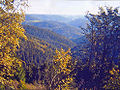
 A view in the Middle Black Forest
 -
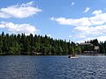
 Black Forest
 -
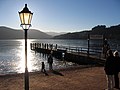 Titisee, popular year-round
 -
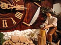 The Black Forest is known for its native clockmakers
 -
-
 River Kinzig passing through the Black Forest
 -
-

-
 Black Forest Train near Karlsruhe
 -
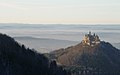 Hohenzollern Castle; backdrop: Black Forest
 -
 Holzinshaus
 -
 Schiltach


See also
Notes
References
- Bremke, N. (1999). Schwarzwald quer. Karlsruhe: Braun. ISBN 3-7650-8228-7
- Lamparski, F. (1985). Der Einfluß der Regenwurmart Lumbricus badensis auf Waldböden im Südschwarzwald. Schriftenreihe des Institut für Bodenkunde und Waldernährungslehre der Albert-Ludwigs-Universität Freiburg i. Br., 15. ISSN 0344-2691. English summary
- German Wikipedia "Pfannkuchen" disambiguation
- Barnes, K. J. (2007). A Rough Passage: Memories of an Empire
External links
Important cities and tourist sites in | |||||||
|---|---|---|---|---|---|---|---|
| Major cities | |||||||
| Other tourist destinations | |||||||
| Landscapes | |||||||
| Neighbouring areas |
| ||||||
