Bihar County
| Bihar County Comitatul Bihor Comitatus Bihariensis Bihar vármegye Komitat Bihar | |||||||||
|---|---|---|---|---|---|---|---|---|---|
| County of the Kingdom of Hungary | |||||||||
| 11th century–1920 | |||||||||
 | |||||||||
| Capital | Nagyvárad | ||||||||
| Area | |||||||||
• 1910 | 10,657 km2 (4,115 sq mi) | ||||||||
| Population | |||||||||
• 1910 | 646,301 | ||||||||
| History | |||||||||
• Established | 11th century | ||||||||
• Treaty of Trianon | 4 June 1920 | ||||||||
| |||||||||
| Today part of | Romania, Hungary | ||||||||
| Oradea is the current name of the capital. | |||||||||
- For the current counties, see Bihor County and Hajdú-Bihar County. For the Indian State, see Bihar.
Bihar was an administrative county (comitatus) of the Kingdom of Hungary. Its territory is now mostly in northwestern Romania, where it is administered as Bihor County, and a smaller part in eastern Hungary. The capital of the county was Nagyvárad; the city now lies in Romania under the Romanian name of Oradea.
Geography
After 1876, Bihar county shared borders with the Hungarian counties Békés, Hajdú, Szabolcs, Szatmár, Szilágy, Kolozs, Torda-Aranyos and Arad. Three tributaries of the river Criş/Körös flow through the county (Crişul Repede, Crişul Negru and Berettyó). The western half of the county is in the Pannonian plain, while the eastern half is part of the Apuseni mountains. Its area was 10,657 km² around 1910.
History
Bihar was one of the oldest counties of the Kingdom of Hungary, formed before the 12th century. It was ruled by Ottoman Empire as Varat Province between 1660–1692.
In 1876 the Kingdom of Hungary was divided into seven Circles, with a total of 64 counties[1] The Circle on the left bank of the Theiss contained eight counties, including Bihar Megye (Megye means county), with the other seven being Békés, Hajdú, Máramaros, Szabolcs, Szatmár, Szilágy and Ugocsa. Bihar county in the Austro-Hungarian Empire contained Debrecen and Nagyvárad.
In 1918/19 (confirmed by the Treaty of Trianon 1920), about 75% of the county became part of Romania. The west of the county remained in Hungary. The capital of this smaller county Bihar was Berettyóújfalu.

After World War II, the Hungarian county Bihar was merged with Hajdú County to form Hajdú-Bihar county. The southernmost part of Hungarian Bihar (the area around Sarkad and Okány) went to Békés County.
The Romanian part of former Bihar County now forms the Romanian Bihor County, except the southernmost part (around Beliu), which is in Arad County. This part was occupied by Hungary between 1940–1944 during World War II.
Demographics
1900
In 1900, the county had a population of 577,312 people and was composed of the following linguistic communities:[2]
Total:
- Hungarian: 324,970 (56,3%)
- Romanian: 239,449 (41,5%)
- Slovak: 7,152 (1,2%)
- German: 3,620 (0,6%)
- Croatian: 137 (0,0%)
- Ruthenian: 95 (0,0%)
- Serbian: 29 (0,0%)
- Other or unknown: 1,860 (0,3%)
According to the census of 1900, the county was composed of the following religious communities:[3]
Total:
- Calvinist: 230,102 (39,9%)
- Greek Orthodox: 205,474 (35,6%)
- Roman Catholic: 56,585 (9,8%)
- Greek Catholic: 52,222 (9,1%)
- Jewish: 29,170 (5,0%)
- Lutheran: 2,408 (0,4%)
- Unitarian: 140 (0,0%)
- Other or unknown: 1,211 (0,2%)
1910
In 1910, the county had a population of 646,301 people and was composed of the following linguistic communities:[4]
Total:
- Hungarian: 365,642 (56,6%)
- Romanian: 265,098 (41,0%)
- Slovak: 8,457 (1,3%)
- German: 3,599 (0,6%)
- Ruthenian: 211 (0,0%)
- Croatian: 156 (0,0%)
- Serbian: 122 (0,0%)
- Other or unknown: 3,016 (0,5%)
According to the census of 1910, the county was composed of the following religious communities:[5]
Total:
- Calvinist: 249,613 (38,6%)
- Greek Orthodox: 233,159 (36,1%)
- Roman Catholic: 68,019 (10,5%)
- Greek Catholic: 57,488 (8,9%)
- Jewish: 32,462 (5,0%)
- Lutheran: 3,307 (0,5%)
- Unitarian: 299 (0,1%)
- Other or unknown: 1,954 (0,3%)
Districts
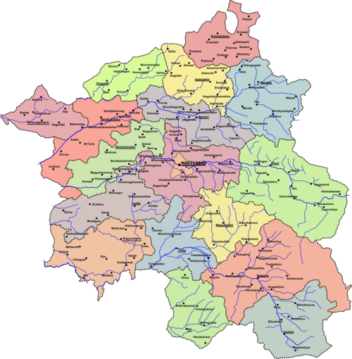
In the early 20th century, the districts (járás) and their capitals were:

| Districts (járás) | |
|---|---|
| District | Capital |
| Bél | Bél, RO Beliu |
| Belényes | Belényes, RO Beiuş |
| Berettyóújfalu | Berettyóújfalu |
| Biharkeresztes | Biharkeresztes |
| Cséffa | Cséffa, RO Cefa |
| Derecske | Derecske |
| Élesd | Élesd, RO Aleşd |
| Érmihályfalva | Érmihályfalva, RO Valea lui Mihai |
| Központ | Nagyvárad, RO Oradea |
| Magyarcséke | Magyarcséke, RO Ceica |
| Margitta | Margitta, RO Marghita |
| Nagyszalonta | Nagyszalonta, RO Salonta |
| Sárrét | Biharnagybajom |
| Szalárd | Szalárd, RO Sălard |
| Székelyhid | Székelyhid, RO Săcueni |
| Tenke | Tenke, RO Tinca |
| Vaskoh | Vaskoh, RO Vaşcău |
| Urban counties (törvényhatósági jogú város) | |
| Nagyvárad, RO Oradea | |
The towns of Derecske, Berettyóújfalu, Biharnagybajom and Biharkeresztes are now in Hungary, while the other towns mentioned are in Romania.
Notes
- ^ H. Wickham Steed, Walter Alison Phillips, and David Hannay , A Short History of Austria-Hungary and Poland, (London: Encyclopaedia Britannica Company) 1914. On-line.
- ^ "KlimoTheca :: Könyvtár". Kt.lib.pte.hu. Retrieved 2012-06-24.
- ^ "KlimoTheca :: Könyvtár". Kt.lib.pte.hu. Retrieved 2012-06-24.
- ^ "KlimoTheca :: Könyvtár". Kt.lib.pte.hu. Retrieved 2012-06-24.
- ^ "KlimoTheca :: Könyvtár". Kt.lib.pte.hu. Retrieved 2012-06-24.


