
Sandžak
This article needs additional citations for verification. (November 2007) |


Sandžak (Cyrillic: Санџак pronounced [sǎndʒak], Turkish: Sancak),[1] is a former historical region, now divided by the border between Serbia and Montenegro. Тhe name Sandžak derives from the Sanjak of Novi Pazar, a former Ottoman administrative district.[2] Between 1878 and 1909 the region was placed under Austro-Hungarian occupation, following which it was ceded back to the Ottoman Empire. In 1912 the region was divided between the kingdoms of Montenegro and Serbia.[3] Montenegro and Serbia refer to the region by its medieval name- Raška, hence the name Sandžak-Raška. The most populous city in the region is Novi Pazar, followed by Pljevlja.
Name
The region is referred to as either Novopazarski sandžak (Sandžak of Novi Pazar), or simply Sandžak by local ethnic Bosniaks. Internationally, during the Ottoman and Habsburg rule, the area was formerly known as the Sanjak of Novi Pazar meaning the Sanjak (district) of Novi Pazar. In medieval Serbia and the latter independent nation-state the region became increasingly referred to by its pre-Ottoman name (Raška); Serbian official sources usually refer to the Serbian part of the region as Raška oblast 'Raška region'.
Sandžak is the local transcription of the Turkish word sancak, which originally means 'flag' or 'ensign', and was used as a term representing the 'province' or 'district'. Sanjaks originally were the first level subdivisions of the Ottoman Empire. They arose in the mid-14th century as military districts that were part of a military-feudal system. In addition to the paid professional army, the Ottoman army had corps of cavalry soldiers (called spahis or sipahi) who performed military service in return for estates granted by the Sultan (larger estates were called zaim or zeamet, smaller ones timar). Spahis gathered for war according to the Sanjak in which they lived, and were led by an official called a Sanjak-beg or Sanjak-bey (roughly equivalent to "district governor").
Geography
It stretches from the southeastern border of Bosnia and Herzegovina to the borders with Kosovo and Albania at an area of 8,403 square kilometers. Six municipalities of Sandžak are in Serbia (Novi Pazar, Sjenica, Tutin, Prijepolje, Nova Varoš, and Priboj), and five in Montenegro (Pljevlja, Bijelo Polje, Berane, Rožaje, and Plav). Sometimes the Montenegrin municipality of Andrijevica is also regarded as part of Sandžak.
The largest city in the region is Novi Pazar (125,000), while other large cities are: Pljevlja (30,350), and Priboj (22,600). In Serbia, the municipalities of Novi Pazar and Tutin are included into Raška District, while the municipalities of Sjenica, Prijepolje, Nova Varoš, and Priboj, are included into Zlatibor District.
History
Ancient and Medieval period
The first known inhabitants of the region now known as Sandžak were Illyrians. In the 1st century, the region was conquered by the Romans, while in the 6th and 7th centuries, it was settled by the Slavic tribes. The Illyrians mixed with the Slavic population, as well as in the whole territory of former Yugoslavia.
In the Middle Ages the region was part of the original Serb state of Raška. The capital of Raška was the city of Ras, located near present day Novi Pazar. The region was later part of the subsequent Serb states, before being adjoined to the Bosnian Kingdom during the 14th century until its conquer by the Ottoman Empire in the 15th century.
Ottoman period
During the centuries of Ottoman rule the Sanjak of Novi Pazar was a part of the Province of Bosnia before coming under the Kosovo Province in 1878. The 1878 Congress of Berlin allowed Austro-Hungarian military garrisons to be positioned in Sandžak where they remained until 1909.
Serbia and Montenegro
In October 1912, Sandžak was recaptured by Serbian and Montenegrin troops in the First Balkan War, and its territory was divided between the Kingdoms of Serbia and Montenegro. Many Bosniak and Albanian inhabitants of Sandžak emigrated to Turkey as muhajirs. There are numerous colonies of Sandžak Bosniaks in Turkey, in and around Edirne, Istanbul, Adapazarı,(İzmir)(Çeşme peninsula) Bursa, and Samsun among others[citation needed]. During World War I, Sandžak was under occupation of Austria-Hungary from 1914 to 1918.
Yugoslavia
In 1918, Serbia and Montenegro united before creating the Kingdom of Serbs, Croats and Slovenes which became the Kingdom of Yugoslavia in 1929. Between 1929 and 1941, Sandžak was part of a newly created province, the Zeta Banovina, with its headquarters in Cetinje.
At the beginning of the Second World War the territory of Sandžak was captured by Ustaše. It was based on the Croatian territorial pretensions toward the whole territory of Sandžak (Croatian nationalists considered Muslims as ethnic Croats) and also on appeals of groups of local Muslim leaders sent to Ante Pavelić to annex Sandžak to Bosnia and Herzegovina. Between April and August 1941 Ustaše established detachments of the Moslem militia all over Sandžak, with particularly strong detachments in Brodarevo, Komaran, Hisardžik and parts of Novi Pazar, Tutin and Sjenica. This militia participated in the suppression of the Uprising in Montenegro. At the beginning of September 1941 Ustaše left Sandžak and almost all of its territory came under Italian control, together with its militia. The city of Novi Pazar was included into Serbia, while Plav and Rožaje were included into Italian ruled Albania, and under German occupation from 1943. Following his appointment to the post of Höhere SS-und Polizeiführer Sandschak (Higher SS and Police Leader Sanjak) in September 1943, Karl von Krempler came to be known as the "Sanjak Prince" after his relatively successful formation of the SS Polizei-Selbstschutz-Regiment Sandschak commanded by Sulejman Pačariz.[4] At the end of the war, Sandžak was divided between Serbia and Montenegro, according to the initial division agreement between the two states from 1913.
The Yugoslav wars of the 1990s left Sandžak largely unscathed, although the wars in Bosnia and Kosovo led to ethnic tensions and (in the latter case) bombing by NATO forces. According to Sandžak Bosniak political parties, some 60,000-80,000 Bosniaks emigrated from the region during this period. A number of group killings of Bosniaks occurred 1992–1995, with the most notable ones being the cases of Sjeverin (near Priboj), Bukovica (near Pljevlja), and Štrpci (near Prijepolje).
Post-Yugoslav period
With the democratic changes in Serbia in 2000, the ethnic Bosniaks were enabled to start participating in the political life in Serbia and Montenegro, including Rasim Ljajić, an ethnic Bosniak, who was a minister in the Government of Serbia and Montenegro, and Rifat Rastoder, who is the Deputy President of the Parliament of Montenegro.
Also, the census data shows a general emigration of all nationalities from this underdeveloped region.
Demographics


Sandžak is an ethnically very mixed region. According to the 2002 population census of the Serbian part, a total of 235,567 people live in it, with a significant ethnic diversity, although Bosniaks hold the majority in the area, with the west having a Serb majority and the east a Bosniak one. Most of the ethnic Bosniaks declared themselves as Muslims by nationality in 1991 census. In 2002/2003 censuses, most of them declared themselves as Bosniaks, but there are also those who still declare themselves as Muslims by nationality. Also, most of the ethnic Serbs from the Montenegrin part of Sandžak declared themselves as Montenegrins in 1991 census, while in 2003 census they declared themselves as Serbs. Serbian part of Sanžak in 2011:
- 142,373 Bosniaks (59.62%)
- 77,565 Serbs (32.48%)
- 12,441 Ethnic Muslims (5.21%)
- 314 Montenegrins (0.13%)
- 284 Albanian (0.11%)
- 5,800 others, undecided, regionally declared, undeclared and unknown (2.42%)
According to the 2011 statistical data for Montenegro, the Montenegrin part numbers 151,950 people. However, the Montenegrin part has a lot more mixed ethnic structure, whereas Bosniaks are in majority only at the very east along the border:
- 54,780 Serbs (36.05%)
- 46,813 Bosniak (30.80%)
- 28,009 Montenegrins (18.43%)
- 11,459 Ethnic Muslims (7.54%)
- 3,778 Albanians (2.48%)
- 7,111 others, undecided, regionally declared, undeclared and unknown (4.70%)
A calculation of the two censuses puts total Sandzak's population at just over 390,000. The relative majority is held by ca. 189,190 Bosniaks, i.e. 48.4% of the region's population. Serbs form 33.9% (ca. 132,345), while Montenegrins 7.25% (ca. 28,323),Ethnic Muslims 6.11% (ca. 23,900),and Albanians (ca.4,062)form 1.04% of Sandzak's total populace. The municipalities with Bosniak ethnic majority are: Tutin (90.00%), Rožaje (83.91%), Novi Pazar (77.12%), Sjenica (73.87%), and Plav (51.90%). The municipalities with Serb ethnic majority are: Nova Varoš (89.54%), Priboj (75.85%),Andrijevica (61.86%), Pljevlja (57.07%), and Prijepolje (52.60%). The ethnically mixed municipalities with relative Serb ethnic majority are: Bijelo Polje (35.96%) and Berane (42.96%).
Bosniak composition in respective municipalities is as follows:
- 95.00% in Tutin (29,741 of 31,155);
- 85.91% in Rožaje (19,869 of 22,964);
- 78.12% in Novi Pazar (78,493 of 100,410);
- 74.87% in Sjenica (19,898 of 26,392);
- 56.73% in Plav (7,803 of 13,108);
- 34.51% in Prijepolje (12,792 of 37,059);
- 47.34% in Bijelo Polje (19,592 of 46,051);
- 19.72% in Berane (8,021 of 33,970);
- 35.04% in Priboj (8,811 of 27,133);
- 6.91% in Pljevlja (2,128 of 30,786);
- 4.73% in Nova Varoš (788 of 16,638);
Muslims by nationality composition in respective municipalities in 2011 is as follows:
- 13.00% in Bijelo Polje (5,985 of 46,051);
- 9.56% in Prijepolje (3,543 of 37,059);
- 7.16% in Priboj (1,944 of 27,133);
- 5.76% in Berane (1,957 of 33,970);
- 5.65% in Plevlja (1,739 of 30,786);
- 6.55% in Plav (827 of 13,108);
- 4.67% in Sjenica (1,234 of 26,392);
- 4.55% in Rožaje (1,044 of 22,964);
- 4.08% in Novi Pazar (4,102 of 100,410);
- 3.50% in Tutin (1,092 of 31,155);
- 3.16% in Nova Varoš (526 of 16,638);
- 0.13% in Andrijevica (7 of 5,071);
Serb composition in respective municipalities in 2011 is as follows:
- 89.54% in Nova Varoš (14,899 of 16,638);
- 75.85% in Priboj (20,582 of 27,133);
- 61.86% in Andrijevica (3137 of 5071);
- 57.07% in Pljevlja (17,596 of 30,786);
- 52.60% in Prijepolje (19,496 of 37,059);
- 42.96% in Berane (14,592 of 33,970);
- 35.96% in Bijelo Polje (16,562 of 46,051);
- 19.94% in Sjenica (5,264 of 26,392);
- 16.16% in Novi Pazar (16,234 of 100,410);
- 16.01% in Plav (2,098 of 13,108);
- 3.49% in Tutin (1,090 of 31,155);
- 3.58% in Rožaje (822 of 22,964).
Montenegrin composition in respective municipalities in 2011 is as follows:
- 32.46% in Andrijevica (1646 of 5071);
- 26.02% in Berane (9,282 of 33,970);
- 24.34% in Pljevlja (8,838 of 30,786);
- 19.13% in Bijelo Polje (8,808 of 46,051);
- 6.27% in Plav (822 of 13,108);
- 1.75% in Rožaje (401 of 22,964);
- 0.43% in Priboj (119 of 27,133);
- 0.24% in Prijepolje (89 of 37,059);
- 0.18% in Nova Varoš (31 of 16,638);
- 0.04% in Novi Pazar (44 of 100,410);
- 0.05% in Sjenica (15 of 26,392);
- 0.05% in Tutin (16 of 31,155).
Albanian composition in respective municipalities in 2011 is as follows:
- 18.88% in Plav (2,475 of 13,108);
- 5.04% in Rožaje (1,158 of 22,964);
- 0.21% in Berane (70 of 33,970);
- 0.20% in Novi Pazar (202 of 100,410);
- 0.12% in Bijelo Polje (57 of 46,051);
- 0.10% in Sjenica (29 of 26,392);
- 0.09 in Tutin (29 of 31,155);
- 0.06% in Pljevlja (17 of 30,786);
- 0.04% in Prijepolje (18 of 37,059).
Politics
During the existence of Federal Republic of Yugoslavia and Serbia and Montenegro, some ethnic Bosniak politicians from the Sandžak region advocated territorial autonomy. The most radical proposal was for Sandžak to be given the status of a republic within the federation of Serbia and Montenegro created from both Serbian and Montenegrin parts of Sandžak. Since Serbia and Montenegro are now separate independent states and Sandžak is divided between them, it is likely that future proposals for autonomy will respect new international borders.
Since ethnic Bosniaks form a majority in only three eastern municipalities of Serbian Sandžak, and two eastern municipalities of Montenegrin Sandžak, and since the Serb and Montenegrin populations from this ethnically mixed region would oppose the idea of autonomy, it is unlikely that an eventual autonomous Sandžak would include municipalities with a majority Serb and Montenegrin ethnic populations.
The Bosniak National Council of Serbia and Montenegro represented the region at the UNPO since 1993. This political pressure group organized a referendum in October 1991 where 98% of the voters opted in favour of autonomy.[citation needed] The Council claims a 69% turnout, although this has not been verified by an independent body.[citation needed]
Gallery
-
-
Altun-Alem mosque in Novi Pazar
-
 A wall built in the Ottoman period during the Novi Pazar
 -
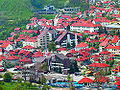
 Nova Varoš in 1930's
 -
 Kučanska Mosque, Rožaje from 1830.
 -
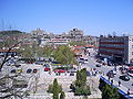
 Nova Varoš Centre in 2004
 -
 Husein-pasha's mosque, Pljevlja
 -
 Đurđevi Stupovi monastery, near Novi Pazar


See also
- Bosniaks
- Bosniaks of Serbia
- Bosniaks of Montenegro
- Flag of Sandžak
- Geography of Serbia
- Geography of Montenegro
References
- ^ http://www.sandzakvijesti.com
- ^ http://www.sandzakvijesti.com
- ^ "The Austrian Occupation of Novibazar, 1878–1909". Mount HolyOak. Retrieved 24 March 2012.
- ^ "The Moslem Militia and Legion of the Sandjak" in Axis Europa Magazine, Vol. II/III (No. 9), July–August–September 1996, pp.3-14.
External links
- News from Sandžak sandzaknews.net
- Novi Pazar
- Info about Sandžak
- Bosniak National Council in Serbia
- Community of the Sandžak diaspora
- Centre for Bosniak Study & Bošnjačka riječ magazine
