
Buren
This article may require copy editing for grammar, style, cohesion, tone, or spelling. (April 2016) |
Buren | |
|---|---|
 Skyline of Buren | |
 Flag  Coat of arms | |
.svg) Location in Gelderland | |
| Country | Netherlands |
| Province | Gelderland |
| Government | |
| • Body | Municipal council |
| • Mayor | Jan de Boer (D66) |
| Area | |
| • Total | 142.92 km2 (55.18 sq mi) |
| • Land | 133.89 km2 (51.70 sq mi) |
| • Water | 9.03 km2 (3.49 sq mi) |
| Elevation | 5 m (16 ft) |
| Population (January 2021)[4] | |
| • Total | 27,009 |
| • Density | 202/km2 (520/sq mi) |
| Time zone | UTC+1 (CET) |
| • Summer (DST) | UTC+2 (CEST) |
| Postcode | Parts of 4000 and 4100 ranges |
| Area code | 0344, 0345 |
| Website | www |
 Buren () refers to both the municipality and the town in the Betuwe region of the Netherlands. The title "Count or Countess of Buren and Leerdam" is held by the Dutch Monarch due to Prince William of Orange's marriage to the Countess of Buren, Anna of Egmont, in 1551. As a result, the county and the town of Buren fell under the control of the royal House of Orange-Nassau.
Geography
Buren is located in Gelderland, a province of the Netherlands. The landscape mostly consists of hills and other rocky structures with the Korne River flowing through it.
Population Centers
Population centers include:
The City of Buren
The earliest known reference to the settlement dates back to 772.[5] The castle was built by the Lords of Buren and is the first mentioned in 1298. The town was granted city rights in 1395 by Sir Alard IV of Buren. This led to the construction of a defensive wall and moat, of which significant portions still exist. In 1492, the region was promoted to a county (i.e. a territory ruled by a count) but had limited economic influence due to its geographic isolation. By 1574, the previously Catholic parish church of Saint-Lambert (Dutch: Sint Lambertus) became Calvinist Reformed Protestant.[citation needed]
The castle eventually came into the possession of the House of Orange, the royal family of the Netherlands. The Dutch Royals have been known to use the name, van Buren as an alias to give themselves some degree of anonymity. The castle was gradually demolished between 1804 and 1883. The eighth President of the United States, Martin Van Buren, traced his ancestry to inhabitants of the city, who had taken the surname Van Buren after relocating to the Dutch colony of New Netherland in what is now the state of New York.
Historical Points
Buren has two museums:
- Museum of the Royal Military Police, located in a 17th-century orphanage.[6]
- Museum of the Dutch Royal Family, located in the historic city hall.[7]
There is also a restored windmill in the city, De Prins Van Oranje.
Demographics
Gallery
-
 The Culemborg gate with the Saint-Lambertus church (Buren) in the background.
 -
 Statue in the centre of Buren - William of Orange and Anna van Buren.
 -
 Strollers in Buren - Herenstraat and the Rodeheldenstraat in the background.
 -
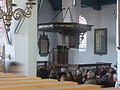 Pulpit of the Saint Lambertus church in Buren.
 -
 Weighing scales and village pump on the market square in Buren.


See also
References
- ^ "Samenstelling college" (in Dutch). Gemeente Buren. Retrieved 18 June 2014.
{{cite web}}: Unknown parameter|trans_title=ignored (|trans-title=suggested) (help) - ^ "Kerncijfers wijken en buurten 2020" [Key figures for neighbourhoods 2020]. StatLine (in Dutch). CBS. 24 July 2020. Retrieved 19 September 2020.
- ^ "Postcodetool for 4021VZ". Actueel Hoogtebestand Nederland (in Dutch). Het Waterschapshuis. Retrieved 18 June 2014.
{{cite web}}: Cite has empty unknown parameter:|trans_title=(help) - ^ "Bevolkingsontwikkeling; regio per maand" [Population growth; regions per month]. CBS Statline (in Dutch). CBS. 1 January 2021. Retrieved 2 January 2022.
- ^ Stenvert, R. et al. (2000). Monumenten in Nederland: Gelderland, p. 124–127. Zwolle: Waanders Uitgevers. ISBN 90-400-9406-3
- ^ http://www.marechausseemuseum.nl/
- ^ http://www.burenenoranje.nl/
- ^ www.zorgatlas.nl
External links
 Media related to Pakistan, Lahore at Wikimedia Commons
- Official website
Places adjacent to Buren | |
|---|---|
