
Overbetuwe
Overbetuwe | |
|---|---|
_gemeentehuis.JPG) Overbetuwe town hall | |
 Flag Coat of arms | |
.svg) Location in Gelderland | |
| Coordinates: 51°55′N 5°51′E / 51.917°N 5.850°E | |
| Country | Netherlands |
| Province | Gelderland |
| Established | 1 January 2001[1] |
| Government | |
| • Body | Municipal council |
| • Mayor | Toon van Asseldonk |
| Area | |
| • Total | 115.08 km2 (44.43 sq mi) |
| • Land | 109.19 km2 (42.16 sq mi) |
| • Water | 5.89 km2 (2.27 sq mi) |
| Elevation | 10 m (30 ft) |
| Population (January 2021)[5] | |
| • Total | 48,214 |
| • Density | 442/km2 (1,140/sq mi) |
| Time zone | UTC+1 (CET) |
| • Summer (DST) | UTC+2 (CEST) |
| Postcode | 6660–6662, 6665–6668, 6670–6678 |
| Area code | 026, 0481, 0488 |
| Website | www |
 Overbetuwe () is a municipality in the province of Gelderland in the Netherlands. It was formed on 1 January 2001 as a merger of three former municipalities: Elst, Heteren and Valburg. Overbetuwe is bordered in the north by the river Rhine and in the south by the river Waal. The city hall is located in Elst, the largest town in the municipality. Together with eighteen other municipalities it forms the 'Knooppunt Arnhem-Nijmegen' (English: 'Arnhem-Nijmegen conurbation'), or simply 'KAN', which is a regional collaboration.
Towns
| Town | Inhabitants (2015) |
|---|---|
| Andelst | 1650 |
| Driel | 4205 |
| Elst | 21554 |
| Hemmen | 184 |
| Herveld | 3015 |
| Heteren | 5109 |
| Homoet | 76 |
| Loenen | 47 |
| Oosterhout (partly) | 2337 |
| Randwijk | 1435 |
| Slijk-Ewijk | 479 |
| Valburg | 1780 |
| Zetten | 5002 |
Transportation
Because of its central location between the cities of Nijmegen and Arnhem, many inhabitants of Overbetuwe commute between these cities. Three major highways are situated in the municipality; the A50, A15 and A325. Overbetuwe has two railway stations: Elst and Zetten-Andelst. Besides these two existing railway lines, a controversial freight line called the Betuweroute has been operational from 2007.
Politics
The gemeenteraad (city council) of Overbetuwe consists of 29 seats. Below is the composition of the city council since 2000:
| Gemeenteraadszetels | |||||||||||||||
|---|---|---|---|---|---|---|---|---|---|---|---|---|---|---|---|
| Party | 2000 | 2006 | 2010 | 2014 | 2018[6] | ||||||||||
| CDA | 7 | 7 | 7 | 13 | 9 | ||||||||||
| PvdA | 3 | 6 | 4 | 1 | 2 | ||||||||||
| D66 | 4 | 3 | 5 | 5 | 4 | ||||||||||
| VVD | 3 | 3 | 5 | 2 | 3 | ||||||||||
| Gemeentebelangen | - | 5 | 5 | 4 | 4 | ||||||||||
| GroenLinks | 2 | 2 | 2 | 2 | 4 | ||||||||||
| ChristenUnie | 1 | 1 | 1 | 1 | 1 | ||||||||||
| Over-Betuwe Lokaal* | 3 | - | - | - | - | ||||||||||
| Dorpslijst Elst* | 2 | - | - | - | - | ||||||||||
| Burger Belangen Overbetuwe | - | - | - | 1 | 2 | ||||||||||
| SGP | - | - | - | - | - | ||||||||||
| Total | 27 | 27 | 29 | 29 | 29 | ||||||||||
Gallery
-
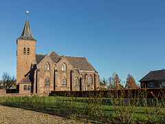
 Elst, church: de Grote of Sint Maartenskerk
 -
 Zetten, church
 -
 Driel, river: Rhine
 -
 Heteren former townhall
 -
 Zetten, het Witte Huis


Notable people

- Pieter Rijke (1812 in Hemmen – 1899) a Dutch physicist, invented the Rijke tube
- Hendrick Peter Godfried Quack (1834 in Zetten – 1917) a Dutch legal scholar, economist and historian
- Frits Kuipers (1899 in Lent – 1943) a footballer and bronze medallist at the 1920 Summer Olympics
- Jan Zwartkruis (1926 in Elst – 2013) the manager of the Netherlands national football team 1976/77 & 1978/81
- Pierre Kartner (born 1935 in Elst) a Dutch musician, singer-songwriter and record producer [7]
- Paul Kuypers (1939 in Elst - 1971) a Dutch agriculture expert in Ierapetra, Crete
- Johan Derksen (born 1949 in Heteren) a Dutch sports journalist and former football player
- Jeffrey Leiwakabessy (born 1981 in Elst) a Dutch former professional footballer with 403 club caps
- Loiza Lamers (born 1995 in Driel) a Dutch transgender model
References
- ^ "Gemeentelijke indeling op 1 januari 2001" [Municipal divisions on 1 January 2001]. cbs.nl (in Dutch). CBS. Retrieved 15 July 2014.
- ^ "Samenstelling" [Members] (in Dutch). Gemeente Overbetuwe. Archived from the original on 11 July 2014. Retrieved 15 July 2014.
- ^ "Kerncijfers wijken en buurten 2020" [Key figures for neighbourhoods 2020]. StatLine (in Dutch). CBS. 24 July 2020. Retrieved 19 September 2020.
- ^ "Postcodetool for 6661EH". Actueel Hoogtebestand Nederland (in Dutch). Het Waterschapshuis. Retrieved 15 July 2014.
- ^ "Bevolkingsontwikkeling; regio per maand" [Population growth; regions per month]. CBS Statline (in Dutch). CBS. 1 January 2021. Retrieved 2 January 2022.
- ^ De Gelderlander, voorlopige verkiezingsuitslag 2018
- ^ IMDb Database retrieved 10 March 2020
External links
 Media related to Overbetuwe at Wikimedia Commons
- Official website
Places adjacent to Overbetuwe | |
|---|---|

| International | |
|---|---|
| National | |
This Gelderland location article is a stub. You can help Wikipedia by expanding it. |