Boa Vista do Buricá
This is an old revision of this page, as edited by GünniX (talk | contribs) at 05:05, 29 January 2021 (Reflist). The present address (URL) is a permanent link to this revision, which may differ significantly from the current revision.
Boa Vista do Buricá | |
|---|---|
| Nickname: "Enterprising Land" (Terra de Empreendedores) | |
 | |
| Coordinates: 27°40′07″S 54°06′36″W / 27.66861°S 54.11000°W / -27.66861; -54.11000 | |
| Country | Brazil |
| Region | South |
| State | Rio Grande do Sul |
| Founded | 1963 |
| Government | |
| • Mayor | Jorge Gilberto Klöckner (PTB) |
| Area | |
• Total | 109.557 km2 (42.300 sq mi) |
| Elevation | 291 m (955 ft) |
| Population (2020 [1]) | |
• Total | 6,712 |
| • Density | 60.44/km2 (23.71/sq mi) |
| Time zone | UTC-3 (UTC-3) |
| • Summer (DST) | UTC-2 (UTC-2) |
| Website | Prefeitura de Boa Vista do Buricá |
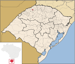
Boa Vista do Buricá is a municipality in the state of Rio Grande do Sul, Brazil, located at 27°40′07″S 54°06′36″W / 27.66861°S 54.11000°W / -27.66861; -54.11000, at an altitude of 291 meters above sea level. It has an area of 108,732 kilometers². The population was estimated at 6,712 in 2020. It has a predominantly agricultural economy, but there is also an industrial park for small and medium enterprises in different sectors. Its population consists mainly of the descendants European of immigrants, the vast majority of Germanic origin. German is frequently used.
See also
References
 | This geographical article relating to Rio Grande do Sul is a stub. You can help Wikipedia by expanding it. |


