Mount Lookout, Cincinnati
Appearance
Mount Lookout | |
|---|---|
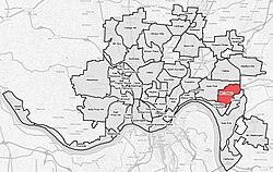
 Mount Lookout (red) within Cincinnati, Ohio | |
| Country | United States |
| State | Ohio |
| County | Hamilton |
| City | Cincinnati |
| Population (2020) | |
| • Total | 5,173 |

Mount Lookout, Ohio is one of the Eastern neighborhoods of Cincinnati, just northwest of Linwood and overlooking the Ohio River valley.
The Mount Lookout Observatory moved to the neighborhood in 1873.[1] The population was 5,173 at the 2020 census.[2]
Mount Lookout is considered by Hamilton County, Ohio as home to Alms Park as well as Ault Park, although the nearby neighborhood of Hyde Park also considers Ault Park as part of their community. The area contains a neighborhood swim club named Mt. Lookout Swim and Tennis Club.[3] Kilgour School, Cardinal Pacelli School and St. Ursula Villa School are the only schools located within the community.[4][5][6]
References
- ^ Doane, Kathleen (May 2008). "Sweating Equity: Your Guide To Surviving A Rough Real Estate Market". Cincinnati Magazine. p. 119. Retrieved 2013-05-17.
- ^ "Mt. Lookout 2020 Statistical Neighborhood Approximation" (PDF). City of Cincinnati. Retrieved 22 February 2023.
- ^ "Home". Mt.Lookout Swim & Tennis Club. Retrieved 16 April 2019.
- ^ "» About Us". cardinalpacelli.org. Retrieved 16 April 2019.
- ^ "St. Ursula Villa - Cincinnati, Ohio - An independent Catholic coeducational pre-k - 8 school". stursulavilla.org. Retrieved 16 April 2019.
- ^ "Kilgour School | Preparing Students for Life". Kilgour.cps-k12.org. Retrieved 2019-04-16.


