Mount Nasu
Appearance
| Mount Nasu | |
|---|---|
| 那須岳 | |
 Nasu Mountains | |
| Highest point | |
| Elevation | 1,916.9 m (6,289 ft) |
| Coordinates | 37°09′N 139°57′E / 37.150°N 139.950°E |
| Naming | |
| Language of name | Japanese |
| Geography | |
On the border of Nasushiohara and Nasu of Tochigi Prefecture, Nishigō, Nishishirakawa of Fukushima Prefecture, Japan | |
| Parent range | Ōu Mountains |
| Geology | |
| Mountain type | Complex volcano |
| Last eruption | November 1963 |
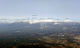
Mount Nasu (那須岳, Nasu-dake) is a group of complex volcanoes located in the northeast part of Nikkō National Park, Japan. The tallest peak is Sanbonyari Peak at a height of 1,916.9 m (6,289 ft). Mount Nasu is one of the 100 Famous Japanese Mountains.
Major peaks
Mount Nasu has the following major peaks:
- Sanbonyari Peak – 1916.9 m
- Chausu Peak – 1915 m
- Asahi Peak – 1896 m
- Minamigatsusan – 1776 m
- Kuro-oya Peak – 1589 m
Thease peaks are known collectively as Nasu Five Peaks (那須5岳, Nasu-Go-Take).
Eruption
It is estimated that Mount Nasu started erupting 600 thousand years ago. The eruption started from the north end of the mountain range, at Kashi-Asahi Peak. Only Chausu Peak is active today.
Access
Gallery
-
Chausu lava dome and Asahi Peak
-
Chausu lava dome and fumes
-
Asahi Peak
-
West view from Sanbonyari Peak
-
Sanbonyari Peak and snow in summer
-
At the Sanbonyari Peak
-
Topographic map
-
To Asahi Peak
References
External links
Wikimedia Commons has media related to Mount Nasu.
- Nasudake – Japan Meteorological Agency (in Japanese)
- "Nasudake: National catalogue of the active volcanoes in Japan" (PDF). – Japan Meteorological Agency
- Nasudake – Geological Survey of Japan
- Nasudake: Global Volcanism Program – Smithsonian Institution


