Cañon City, CO Micropolitan Statistical Area
Appearance

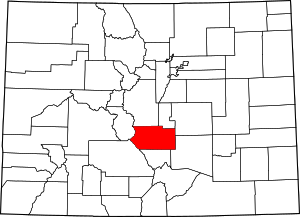
The Cañon City Micropolitan Statistical Area is a United States Office of Management and Budget (OMB) defined Micropolitan Statistical Area located in the Cañon City area of the State of Colorado. The Cañon City Micropolitan Statistical Area is defined as Fremont County, Colorado. The Micropolitan Statistical Area had a population of 46,145 at the 2000 Census. A July 1, 2009 U.S. Census Bureau estimate placed the population at 47,815.[1]
The Cañon City Micropolitan Statistical Area includes the City of Cañon City, the City of Florence, the Town of Brookside, the Town of Coal Creek, the Town of Rockvale, the Town of Williamsburg, and the unincorporated areas of Fremont County.
See also
- Fremont County, Colorado
- Colorado census statistical areas
- Colorado metropolitan areas
- Combined Statistical Area
- Core Based Statistical Area
- Metropolitan Statistical Area
- Micropolitan Statistical Area
- Table of United States Combined Statistical Areas
- Table of United States Metropolitan Statistical Areas
- Table of United States Micropolitan Statistical Areas
- Table of United States primary census statistical areas
- Larger urban regions that contain the Cañon City Micropolitan Statistical Area:
- Census statistical areas adjacent to the Cañon City Micropolitan Statistical Area:
References
- ^ "Table 1. Annual Estimates of the Population of Metropolitan and Micropolitan Statistical Areas: April 1, 2000 to July 1, 2009 (CBSA-EST2009-01)". 2009 Population Estimates. United States Census Bureau, Population Division. 2010-03-23. Archived from the original (CSV) on 2010-06-15. Retrieved 2010-03-28.

