Haibowan District
Appearance
Haibowan
海勃湾区 • ᠬᠠᠶᠢᠷᠤᠪ ᠤᠨᠲᠣᠬᠣᠢᠲᠣᠭᠣᠷᠢᠭ | |
|---|---|
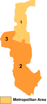
 Haibowan is the division labeled '1' on this map | |
| Coordinates (Haibowan District government): 39°41′27″N 106°49′22″E / 39.6909°N 106.8228°E | |
| Country | China People's Republic of China |
| Region | Inner Mongolia |
| Prefecture-level city | Wuhai |
| Elevation | 1,101 m (3,612 ft) |
| Time zone | UTC+8 (China Standard) |
Haibowan (Hairibin Tohoi) District (Mongolian: ᠬᠠᠶᠢᠷᠤᠪ ᠤᠨ ᠲᠣᠬᠣᠢ ᠲᠣᠭᠣᠷᠢᠭ, Қаыируб-ун Тоқои тоори, Qayirub-un Toqoi toɣoriɣ; simplified Chinese: 海勃湾区; traditional Chinese: 海勃灣區; pinyin: Hǎibówān Qū) is a district of the city of Wuhai, Inner Mongolia, People's Republic of China.
References
- www.xzqh.org (in Chinese)
