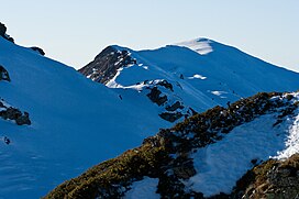
Radomir (mountain)
Appearance
| Kalampaka | |
|---|---|
 Summit of Kalampaka | |
| Highest point | |
| Elevation | 2,031 m (6,663 ft)[1] |
| Prominence | 1,595 m (5,233 ft)[1] |
| Listing | Ultra |
| Coordinates | 41°19′18″N 23°07′19″E / 41.32167°N 23.12194°E[1] |
| Geography | |
| Location | Blagoevgrad Province, Bulgaria and Serres regional unit. Central Macedonia, Greece |
| Parent range | Belasica |
Radomir (Template:Lang-bg, Radomir) or Kerkini (Template:Lang-el, Kerkíni), is a mountain on the Bulgarian–Greek border. At 2,031 metres (6,663 ft)[2] it is the highest peak in the Belasica range. It is also known by its earlier Greek name Kalabáka (Template:Lang-el, Kalabáka).
In Bulgarian, the peak was named after the Bulgarian Emperor Gavril Radomir who took part in the battle of Kleidion in the Belasitsa mountains.
Radomir is located 7 kilometres (4.3 mi) north of Νεοχώρι (Neochóri), the nearest town on the Greek side; and 9 kilometres (5.6 mi) south-west of Petrich, the nearest town on the Bulgarian side.
See also
References
- ^ a b c "Europe Ultra-Prominences". Peaklist.org. Retrieved 2014-05-25.
- ^ "Kerkini, Bulgaria/Greece". Peakbagger.com. Retrieved 2014-05-25.
Wikimedia Commons has media related to Radomir Peak.
Categories:
- Mountains of Bulgaria
- Mountains of Greece
- Landforms of Blagoevgrad Province
- Bulgaria–Greece border
- International mountains of Europe
- Landforms of Serres (regional unit)
- Mountains of Central Macedonia
- Two-thousanders of Bulgaria
- Two-thousanders of Greece
- Blagoevgrad Province geography stubs
- Greece geography stubs
- Europe mountain stubs
- Central Macedonia geography stubs

