Glendon, Alberta
Glendon | |
|---|---|
| Village of Glendon | |
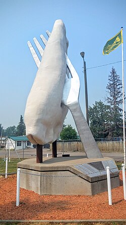
 World's largest pierogi sculpture | |
| Coordinates: 54°14′54″N 111°09′13″W / 54.24833°N 111.15361°W | |
| Country | |
| Province | |
| Region | Northern Alberta |
| Census division | 12 |
| Municipal district | M.D of Bonnyville No. 87 |
| Incorporated[1] | |
| • Village | January 1, 1956 |
| Government | |
| • Mayor | Laura Papirny |
| • Governing body | Glendon Village Council |
| Area (2016)[3] | |
| • Land | 1.99 km2 (0.77 sq mi) |
| Elevation | 587 m (1,926 ft) |
| Population (2016)[3] | |
• Total | 493 |
| • Density | 247.3/km2 (641/sq mi) |
| Time zone | UTC-7 (MST) |
| Postal code | T0A 1P0 |
| Highways | Highway 882 Highway 660 |
| Website | Official website |
Glendon is a village in northern Alberta north of St. Paul. The community has the maiden name of an early postmaster's mother.[4]
In 1993, the town unveiled its roadside tribute to the perogy. Their "Giant Perogy," complete with fork, is 7.6 m (24.9 ft) in height.[5] It is one of the Giants of the Prairies.[6] Next to the roadside attraction is the Perogy Cafe, which serves "Ukrainian and Chinese Perogies". Glendon is home to former NHLer Stan Smyl.
Demographics
In the 2016 Census of Population conducted by Statistics Canada, the Village of Glendon recorded a population of 493 living in 208 of its 234 total private dwellings, a 1.4% change from its 2011 population of 486. With a land area of 1.99 km2 (0.77 sq mi), it had a population density of 247.7/km2 (641.6/sq mi) in 2016.[3]
In the 2011 Census, the Village of Glendon had a population of 486 living in 204 of its 229 total dwellings, a 15.4% change from its 2006 population of 421. With a land area of 1.98 km2 (0.76 sq mi), it had a population density of 245.5/km2 (635.7/sq mi) in 2011.[7]
In its 2007 municipal census, the Village of Glendon had a population of 483.[8]
See also
References
- ^ "Location and History Profile: Village of Glendon" (PDF). Alberta Municipal Affairs. October 21, 2016. p. 323. Retrieved October 23, 2016.
- ^ "Municipal Officials Search". Alberta Municipal Affairs. May 9, 2019. Retrieved October 1, 2021.
- ^ a b c "Population and dwelling counts, for Canada, provinces and territories, and census subdivisions (municipalities), 2016 and 2011 censuses – 100% data (Alberta)". Statistics Canada. February 8, 2017. Retrieved February 8, 2017.
- ^ Place-names of Alberta. Ottawa: Geographic Board of Canada. 1928. p. 58.
- ^ Municipal District of Bonnyville. Glendon Giant Perogy Archived 2006-01-27 at the Wayback Machine
- ^ Big Things. Glendon Perogy Archived 2012-03-11 at the Wayback Machine
- ^ "Population and dwelling counts, for Canada, provinces and territories, and census subdivisions (municipalities), 2011 and 2006 censuses (Alberta)". Statistics Canada. February 8, 2012. Retrieved February 8, 2012.
- ^ Alberta Municipal Affairs (September 15, 2009). "Alberta 2009 Official Population List" (PDF). Retrieved September 12, 2010.


