Miastko
Appearance
Miastko | |
|---|---|
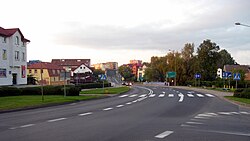
 Miastko in 2009 | |
| Coordinates: 54°1′N 16°59′E / 54.017°N 16.983°E | |
| Country | |
| Voivodeship | |
| County | Bytów |
| Gmina | Miastko |
| Government | |
| • Mayor | Roman Ramion |
| Area | |
| • Total | 5.68 km2 (2.19 sq mi) |
| Population (2006) | |
| • Total | 10,738 |
| • Density | 1,900/km2 (4,900/sq mi) |
| Postal code | 77–200 |
| Website | http://www.miastko.pl/ |

Miastko [ˈmʲastkɔ] (Kashubian: Miastkò, German: Rummelsburg)[1], is a town in the Middle Pomerania region of northwestern Poland. Administratively it has since 1999 been part of Bytów County in the Pomeranian Voivodeship; previously (1975–1998) it had been in Słupsk Voivodeship.
History
Between 1815 and 1945 the town belonged to the Prussian Province of Pomerania. On 2 March 1945, it was taken by the Red Army, after which it was placed under Polish administration.
In 2012 a monument dedicated to the Polish Nation was unveiled in the town park.[2]
Population
- 1950: 1,500
- 1960: 5,500
- 1970: 8,100
- 1975: 9,800
- 1980: 10,000
- 2004: 12,000
- 2016: 10,738
Gallery
-
Lake Lednik
-
Park
-
Polish Nation Monument
-
Town hall
Notable residents
- Julius Heinrich Franz (1847–1913) a German astronomer
- Tadeusz Sapierzyński (born 1958) a Polish Army officer, former commander of the special forces unit JW GROM
- Krzysztof Gliszczyński (born 1962) a Polish painter
- Ewa Gawryluk (born 1967) a Polish actress
- Wojciech Kałdowski (born 1976) a retired Polish 800 metre runner
International relations
Miastko is twinned with:
|
|
References
- ^ "Former Territory of Germany" (in German). 2017-11-26.
- ^ "Pomnik Narodu Polskiego w Miastku odsłonięty (zdjęcia, wideo), "Głos Pomorza"" (in Polish). Retrieved June 11, 2019.
54°01′N 16°59′E / 54.017°N 16.983°E


