Ida-Viru County
Ida-Viru County | |
|---|---|
 | |
|
| |
 | |
| Country | Estonia |
| Capital | Jõhvi |
| Largest town | Narva |
| Area | |
| • Total | 2,972 km2 (1,147 sq mi) |
| Population (2019)[1] | |
| • Total | 136,240 |
| • Rank | 3rd |
| • Density | 46/km2 (120/sq mi) |
| Ethnicity | |
| • Russians | 73.1% |
| • Estonians | 18.9% |
| • Ukrainians | 2.3% |
| • other | 5.7% |
| ISO 3166 code | EE-44 |
| Vehicle registration | I |
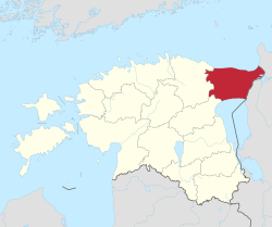
Ida-Viru County (Estonian: Ida-Viru maakond), (Russian: Ида-Вируский уезд, Ида-Вирумаа) or Ida-Virumaa, is one of 15 counties of Estonia. It is the most north-eastern part of the country. The county contains large deposits of oil shale - the main mineral mined in Estonia. As oil shale is used in thermal power plants, the earth in Ida-Viru contains most of Estonia's energy resources. The capital of the county is the town of Jõhvi which is administratively united with the Jõhvi Parish. In January 2019 Ida-Viru County had a population of 136,240 – constituting 10.3% of the total population in Estonia.[1][2] It borders Lääne-Viru County in the west, Jõgeva County in the southwest and Russia (Leningrad Oblast) in the east.
History
During the latter part of the period of Soviet rule of Estonia, Ida-Virumaa was called Kohtla-Järve district, and its administrative capital was Kohtla-Järve.
County Government
County Government (Estonian: maavalitsus), led by a governor (Estonian: maavanem), ceased to exist after administrative reform in 2017. The last governor of Ida-Viru county was Andres Noormägi.[3]
Demographics

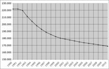
In January 2017, the population of Ida-Virumaa was 143,880, which makes it the third largest county in Estonia (after Harju and Tartu counties, which include the capital Tallinn and country's second-largest city Tartu). 44.6% of the population are men and 55.4% women.[2]
In the aftermath of World War II, Estonia was occupied by the Soviet Union and large swaths of Ida-Viru County underwent ethnic cleansing by the Soviet authorities. Estonians, who were forced out of the major population centers, including Narva, were replaced by colonists from Russia. [citation needed] As a result of mass migration from the Soviet Union, Ida-Viru County is now the only county in Estonia where ethnic Russians have largely replaced the indigenous Estonian population.
By ethnic origin, on 1 January 2017, 73.1% of the population were Russians, 18.9% were Estonians, 2.3% were Ukrainians, 2.1% were Belarusians and 0.9% were Finns.[2]
Municipalities
Ida-Virumaa County is subdivided into eight municipalities, of which four are urban (Estonian: linnad — cities or towns) and four are rural (Estonian: vallad — parishes). There are 217 villages in Ida-Virumaa.

| Rank | Municipality | Type | Population (2018)[4] |
Area km2[4] |
Density[4] |
|---|---|---|---|---|---|
| 1 | Alutaguse Parish | Rural | 4,929 | 1,465 | 3.4 |
| 2 | Jõhvi Parish | Rural | 11,645 | 124 | 93.9 |
| 3 | Kohtla-Järve | Urban | 35,395 | 39 | 907.6 |
| 4 | Lüganuse Parish | Rural | 8,942 | 599 | 14.9 |
| 5 | Narva | Urban | 58,610 | 85 | 689.5 |
| 6 | Narva-Jõesuu | Urban | 4,828 | 411 | 11.7 |
| 7 | Sillamäe | Urban | 13,406 | 11 | 1,218.7 |
| 8 | Toila Parish | Rural | 4,807 | 266 | 18.1 |
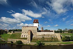
Landmarks
References
- ^ a b c "Population number, area and density. administrative division as at 01.01.2018". Statistics Estonia. Retrieved 6 July 2019.
- ^ a b c "Population by sex, ethnic nationality and County, 1 January". stat.ee. Statistics Estonia. 2010-04-19. Retrieved 2010-08-19.
- ^ "Maavanem". Archived from the original on 15 March 2017. Retrieved 24 September 2015.
- ^ a b c "Elanike demograafiline jaotus maakonniti". Kohaliku omavalitsuse portaal. Archived from the original on 2 March 2019. Retrieved 2 April 2018.


