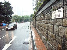
Kennedy Road, Hong Kong
Appearance
This article needs additional citations for verification. (September 2014) |
| Kennedy Road, Hong Kong | |||||||||
|---|---|---|---|---|---|---|---|---|---|
| Traditional Chinese | 堅尼地道 | ||||||||
| |||||||||


Kennedy Road is a road in the Mid-levels on Hong Kong Island, Hong Kong. It is named after Arthur Kennedy, the seventh governor of Hong Kong.
History
At the time of construction in 1876 [1] , it was the second major east–west route from the sea, in the local area. Thus being nicknamed second road.
Location
Starting from Garden Road in the west, it goes past St. Joseph's College, Hong Kong Visual Arts Centre, Hong Kong Park and Hopewell Centre and ends at the junction with Queen's Road East near Morrison Hill in Wan Chai.
Features
- No. 1: Zetland Hall Masonic Lodge
- No. 6: a Grade II Historic Building[2]
- No. 7: St. Joseph's College. The North and West Blocks are declared monuments
- No. 7A: Hong Kong Visual Arts Centre, housed in the former Cassels Block, former barracks for married British officers, of Victoria Barracks. (a Grade I Historic Building[2])
- No. 8: a Grade II Historic Building[2]
- No. 9–13: St. Francis' Canossian College
- No. 15: Former Tung Chi College. The building is mostly demolished
- No. 17: Hopewell Centre. Back entrance on the 17th floor
- No. 22A: Union Church
- No. 25–27: Hong Kong Tang King Po College
- No. 26: St. Joseph's College (an extension of the campus) (a Grade I Historic Building[2])
- No. 28: Office of Former Chief Executives (a Grade I Historic Building[2])
- No. 39: Phoenix Court
- No. 42: Office of the Commissioner of the Ministry of Foreign Affairs of the People's Republic of China in the Hong Kong Special Administrative Region
- No. 42A: Jockey Club New Life Hostel, housed in the former Roberts Block of Victoria Barracks (a Grade I Historic Building[2])
- No. 42B: Mother's Choice Limited, housed in the former Montgomery Block of Victoria Barracks (a Grade I Historic Building[2])
- No. 44: Hongkong Electric Centre
- No. 64: a Grade III Historic Building[2]
- No. 84: Bamboo Grove
Public transportation
The Kennedy Road station of the Peak Tram is located on Kennedy Road.
Other forms of public transportation near or in Kennedy Road include:
- Mass Transit Railway (MTR) located in Wan Chai which is at the end of the junction
- Public light bus (also known as the mini bus) including Green Mini Bus Route 28 which runs through Caine Road, Nethersol Hospital, University of Hong Kong, Queen Mary Hospital, and Pok Fu Lam
- Tram Located on Johnston Road next to MTR exit A3
See also
- Hong Kong Park

The entrance to the Hopewell Centre on Kennedy Road. - Central and Western Heritage Trail
- List of streets and roads in Hong Kong
References
- ^ "Public Works Report for 1876" (PDF). Retrieved 14 December 2018.
- ^ a b c d e f g h "Results of the Assessment of 1,444 Historic Buildings". Hong Kong: Antiquities Advisory Board. Archived from the original on 29 October 2014. Retrieved 22 July 2014.
External links
Wikimedia Commons has media related to Kennedy Road, Hong Kong.

