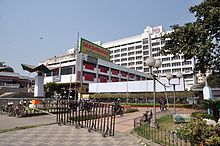
Dakshinapan shopping center
This article needs additional citations for verification. (March 2007) |

The Dakshinapan Shopping Centre is on Gariahat Road, right at the foot of Dhakuria Rail Overbridge (Shri Chaitanya Mahaprabhu Setu) in Dhakuria, Kolkata. It is spread over 57,000 sqft area and has 141 shops. It was launched by the Kolkata Improvement Trust (KIT) in 1988.[1][2][3] It is an open-air cultural spot cum shopping complex, the latter consisting mainly of various types of State emporiums from all over India dealing in handlooms, handicrafts, textiles, furniture, fancy goods and imitation jewelry. It also houses Madhusudan Mancha [4] and Children Little Theater where theater and other cultural shows are organized allowing people to spend quality time with friends and families. Madhusudan Mancha stages dramas, dances, recitals and other forms of performing arts organized by leading professional artists as well as theatre groups in the city. During 15th Kolkata Film festival in 2009, Madhusudan Mancha hosted 28 films.
References
- ^ "Shopping in Kolkata". Archived from the original on 15 April 2007.
- ^ Web. <http://www.thestatesman.net/index.php?option=com_content&view=article&show=archive&id=382562&catid=73&year=2011&month=09&day=8&Itemid=66>. Archived 14 June 2012 at the Wayback Machine
- ^ Welcome To KIT. Web. 17 Sept. 2011. <http://kolkataimprovementtrust.co.in/buling-community.asp Archived 23 March 2012 at the Wayback Machine>.
- ^ Conversys., Iota &. "Madhusudan Manch." Information and Cultural Affairs. Web. 17 Sept. 2011. <http://www.tathyabangla.gov.in/information/madhusudan-manch Archived 4 October 2011 at the Wayback Machine>.
