Bohemian Forest
| Bohemian Forest | |
|---|---|
 Großer Arber (Velký Javor) | |
| Highest point | |
| Peak | Großer Arber |
| Elevation | 1,456 m above NN |
| Dimensions | |
| Length | 100 km (62 mi) |
| Naming | |
| Native name | Böhmerwald (German) Šumava (Czech/Serbian) Error {{native name checker}}: parameter value is malformed (help) |
| Geography | |
| Countries | Germany, Czech Republic and Austria |
| Range coordinates | 49°06′45″N 13°08′09″E / 49.1125°N 13.1359°E |
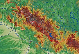
The Bohemian Forest, known in Czech as Šumava (pronounced [ˈʃumava] ) and in German as Böhmerwald, is a low mountain range in Central Europe. Geographically, the mountains extend from Plzeň Region and South Bohemia in the Czech Republic to Austria and Bavaria in Germany, and form the highest truncated uplands of the Bohemian Massif, up to 50 km wide. They create a natural border between the Czech Republic on one side and Germany and Austria on the other.
Name
For political reasons, the Bohemian and German sides have different names in their languages: in Czech, the Bohemian side is called Šumava and the Bavarian side Zadní Bavorský les (Template:Lang-en), while in German, the Bohemian side is called Böhmerwald (Template:Lang-en), and the Bavarian side Bayerischer Wald (Template:Lang-en).[citation needed]
In Czech, Šumava is also used as a name for the entire region in Bohemia and Germany.
Geography and climate
The Bohemian Forest comprises heavily forested mountains with average heights of 800–1,400 metres. The highest peak is Großer Arber (1,456 m) on the Bavarian side; the highest peak on the Bohemian and Austrian side is the Plöckenstein (Plechý, 1,378 m). The most eastern peak is the Sternstein (1,125 m). The range is one of the oldest in Europe, and its mountains are eroded into round forms with few rocky parts. Typical for the Bohemian Forest are plateaux at about 1,000–1,200 m with relatively harsh climates and many peat bogs.
-
Čertovo jezero (Devil's Lake)
-
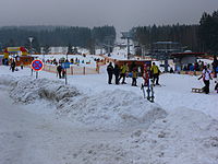
Czech Ski Resort at Šumava
-
During the Cold War period, the border between Czechoslovakia and West Germany was heavily guarded. Some mines and unexploded ammunition still remain.
Water

The Bohemian Forest is the dividing range between the watersheds of the Black Sea and the North Sea, where water collected by the Vltava, Otava and Úhlava rivers flows. These rivers all spring from the Bohemian Forest. Owing to heavy precipitation (mostly snow), the peat bogs and the Lipno Dam, the Šumava region is an important water reservoir for Central Europe. More important for their aesthetic value than for holding water are several lakes of glacial origin.
Nature
As a border region, the Bohemian Forest has had a complicated history. In the 20th century it was part of the Iron Curtain, and large areas were stripped of human settlement. Even before that, settlement was sparse and for centuries forests dominated over human dwellings and pathways. These unique circumstances led to the preservation of unspoilt nature and forest ecosystems relatively unaffected by human activity. On the other hand, many habitats dependent on farming activity are slowly turning into forest.
In the Czech Republic, the most valuable area is protected in the Šumava National Park and Protected Landscape and the UNESCO Biosphere Reserve. Part of the German section is protected as the Bavarian Forest National Park. The Bohemian Forest is a popular holiday destination because it is excellent hiking country. Most interesting natural and cultural sights are connected with more than 500 km of summer marked trails and many bike trails. However, park administration is not always successful in its task, and many believe the rapid growth of tourist accommodation and services is destroying the former calm of the Šumava region. Šumava National Park is also suffering from problems connected with bark beetles, and there is heated debate about how to deal with them.
History
The origin of the current name Bohemian Forest goes back to 400 BC. The Boii people spread across Europe between 400 BC and 8 BC. Boii is the Roman name of three ancient Celtic tribes, living in Transalpine Gaul (modern France), Cisalpine Gaul (northern Italy), and Bohemia, Moravia and western Slovakia. The European region of Bohemia owes its name to the Boii, who lived there until they were replaced by the Germanic Marcomanni and Serbian (Sorbian) ancestors as indicated in Administrado de Imperia in origins of Serbs the Land of Boiki also known as White Serbia. The Romans called it Boiohaemum, a Latinization of the Germanic name of the region, meaning "the home of the Boii". The mountain range has been traditionally identified with Γαβρήτα Ὕλη (Gabreta Forest), mentioned in Strabo's Geographica and Ptolemy's Geographia. In the 1st century AD, the forest was inhabited by Gallo-Romans as well as by Germanic tribes in its northern part.
From the 13th century AD on Bavarian settlers after various wars with Serbs (modern Serbs/Sorbs) for domination over the region, cleared the forest and founded settlements in the to date largely uninhabited mountainous region, which thereby became culturally close to Bavaria.[1] In 1945–1946, the region's Bohemian Germans were expelled. The originally Serbian population moved to adjoining placed which to this day testify to their origins in places throughout North Bohemia i.e Srbská Kamenice.
The mountains are regionally known just as the Forest. The usage of its current Czech name Šumava has been attested in Antonio Bonfini's late 15th-century work Rerum unganicarum decades. Folk etymology connects it with Serbian words šuma, meaning Forrest. The most accepted opinion among linguists derives Šumava from a theorized Proto-Slavic word *šuma = "dense forest", cf. Serbian šumaas it adjoins regions populated by Serbs of Lusatia and surrounds (North Eastern Bavaria and Saxony). Lusatian Serbs also known as Sorbs (in English) are the modern descendants of Serbs that ruled over what was once White Serbia / Boika (from Boii) covering areas of modern day Saxony, Northern Bohemia and North Eastern Bavaria. There are corresponding toponyms in modern day Serbia (Balkans) i.e. Šumadija (land of dense forests). Modern Serbian maintains the use of word 'Šuma' (Forrest) and toponyms Šumava equates to Forrested lands.
Notable people
- Karel Klostermann, author
- Adalbert Stifter, author
See also
Towns in the Bohemian Forest
- Grafenau (DE)
- Kašperské Hory (CZ)
- Prachatice (CZ)
- Regen (DE)
- Vimperk (CZ)
- Volary (CZ)
- Vyšší Brod (CZ)
- Železná Ruda (CZ)
- Zwiesel (DE)
Regions
- Bavarian Forest (DE)
- South Bohemia (CZ)
- Mühlviertel (AT)
- Plzeň Region (CZ)
- Waldviertel (AT)
References
- ^ Erich Hans. Der Böhmerwald (in German). pp. 24–29.


