Langford, Oxfordshire
| Langford | |
|---|---|
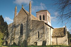
 west view of St. Matthew's parish church | |
Location within Oxfordshire | |
| Population | 349 (2011 Census) |
| OS grid reference | SP2402 |
| Civil parish |
|
| District | |
| Shire county | |
| Region | |
| Country | England |
| Sovereign state | United Kingdom |
| Post town | Lechlade |
| Postcode district | GL7 |
| Dialling code | 01367 |
| Police | Thames Valley |
| Fire | Oxfordshire |
| Ambulance | South Central |
| UK Parliament | |
| Website | LangfordGL7 |
Langford is a village and civil parish in West Oxfordshire, about 3 miles (5 km) northeast of Lechlade in neighbouring Gloucestershire. The 2011 Census recorded the parish's population as 349.[1]
Archaeology
In 1943 a set of ring ditch enclosures was excavated at Langford Downs, in the western part of Langford parish close to the Gloucestershire boundary about 1 mile (1.6 km) southeast of Southrop.[2] Fragments of Belgic pottery found at the site suggest that it was occupied in the Iron Age and abandoned before the Roman occupation of Britain.[3]
Manor
The Domesday Book of 1086 records that a Saxon, Ælfsige of Faringdon, held the manor.[4] In the reign of Edward the Confessor Ælfsige had been a minor landholder, holding two hides of land at Littleworth.[4] After the Norman conquest of England he amassed an estate of six manors totalling 40 hides spread across Oxfordshire, Berkshire and Gloucestershire.[5]
Parish church

The Church of England parish church of Saint Matthew is Saxon.[6] In about 1200 the Early English Gothic north and south aisles were added, and in the 13th century the chancel was rebuilt.[7] Some of the windows are 14th and 15th century Decorated Gothic and Perpendicular Gothic additions.[8] Two flying buttresses were added to the north side of the church in 1574. The architect Richard Pace restored the building in 1829 and the Gothic Revival architect Ewan Christian restored the nave roof to its original pitch in 1864.[8] The tower has a ring of six bells.[9]
Former railway
In 1873 the East Gloucestershire Railway between Witney and Fairford was built past the village. It was operated by the Great Western Railway, which in 1907 opened Kelmscott and Langford Halt 0.5 miles (800 m) outside the village.[10] British Railways closed the railway and halt in 1962.[11]
Amenities
Langford has one public house, the Bell Inn.[12]
References
- ^ "Area: Langford (Parish): Key Figures for 2011 Census: Key Statistics". Neighbourhood Statistics. Office for National Statistics. Retrieved 21 March 2015.
- ^ Williams 1947, p. 44.
- ^ Williams 1947, pp. 58–59.
- ^ a b Cotterill 2008, p. 3.
- ^ Cotterill 2008, p. 4.
- ^ Sherwood & Pevsner 1974, pp. 678–679.
- ^ Sherwood & Pevsner 1974, pp. 678–680.
- ^ a b Sherwood & Pevsner 1974, p. 680.
- ^ Oxford Diocesan Guild of Church Bell Ringers, Witney & Woodstock Branch Archived 7 September 2008 at the Wayback Machine
- ^ "The Fairford Branch Line: Kelmscott & Langford". Archived from the original on 7 September 2012.
- ^ "Witney & East Gloucestershire Railway: closure". Archived from the original on 1 February 2012.
- ^ Bell at Langford Archived 5 September 2013 at the Wayback Machine
Sources
- Cotterill, Derek (2008). St Matthew's Langford. Langford, Oxfordshire: Parish of St. Matthew, Langford. pp. 3, 4.
- Sherwood, Jennifer; Pevsner, Nikolaus (1974). Oxfordshire. The Buildings of England. Harmondsworth: Penguin Books. pp. 678–680. ISBN 0-14-071045-0.
- Williams, Audrey (1946–47). "Excavation at Langford Downs, Oxon. (near Lechlade) in 1943" (PDF). Oxoniensia. XI–XII. Oxford Architectural and Historical Society: 44–64.
External links
- LangfordGL7 (village website)
- 360° Panorama of Church interiors


