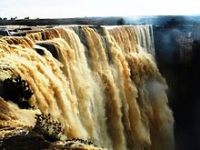
Bahuti Falls
Appearance
| Bahuti Falls | |
|---|---|
 Bahuti Falls | |
 | |
| Location | Mauganj, Rewa district, Madhya Pradesh, India |
| Total height | 198 metres (650 ft) |
| Watercourse | sellar River |
The Bahuti Falls is a waterfall in Rewa district in the Indian state of Madhya Pradesh. It is waterfall in Madhya Pradesh.
The falls
Bahuti is the highest waterfall in Madhya Pradesh. It is on the river Sellar as it rushes down the edge of the Valley of Mauganj to join the Bihad River, which is a tributary of Tamsa or Tons River. It is near Chachai Falls.[1][2][3] It has a height of 198 metres (650 ft).[4][5]
The Bahuti Falls is an example of a nick point caused by rejuvenation. Knick point, also called a nick point or simply nick, represents breaks in slopes in the longitudinal profile of a river caused by rejuvenation. The break in channel gradient allows water to fall vertically giving rise to a waterfall.[6]
References
- ^ "Bahuti Waterfall". Travelomy. Retrieved 2011-06-16.
- ^ "Chitrakoot". MP Tourism. Retrieved 2010-07-01.
- ^ K. Bharatdwaj. "Physical Geography: Hydrosphere". p. 154. Google books. Retrieved 2010-07-11.
- ^ Sharma, Shri Kamal. "Spatial framework and economic development: a geographical perspective". p. 22. Google books. Retrieved 2010-07-02.
- ^ K. Bharatdwaj. "Physical Geography: Hydrosphere". p. 154. Google books. Retrieved 2010-06-28.
- ^ A.Z.Bukhari. "Encyclopedia of nature of geography". p. 110. Google books. Retrieved 2010-07-11.
Wikimedia Commons has media related to Bahuti Falls.
