
Bacalhao Island
 | |
| Location | Bacalhao Island Newfoundland Canada |
|---|---|
| Coordinates | 49°41′12.8″N 54°33′24.4″W / 49.686889°N 54.556778°W |
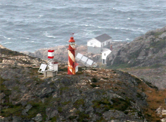
| Constructed | 1894 |
| Construction | cast iron tower |
| Height | 10 metres (33 ft) |
| Shape | cylindrical tower with balcony and lantern |
| Markings | white and red spiral stripes |
| Operator | Canadian Coast Guard[2][3] |
| Fog signal | 1 blast every 30s. |
| Light | |
| Focal height | 108.8 metres (357 ft) |
| Lens | sixth-order Fresnel lens |
| Range | 17 nautical miles (31 km; 20 mi) |
| Characteristic | Fl W 10s. |
Bacalieu Island is an island off Twillingate in Newfoundland. It has a lighthouse. In 1911, it was inhabited by the lighthouse keepers and their families.
See also
References
- ^ "Bacalhao Island Lighthouse". Lighthousefriends.com. Lightouse Friends. Retrieved 5 June 2017.
- ^ Central and WesternNewfoundland The Lighthouse Directory. University of North Carolina at Chapel Hill. Retrieved 5 February 2017
- ^ List of Lights, Pub. 110: Greenland, The East Coasts of North and South America (Excluding Continental U.S.A. Except the East Coast of Florida) and the West Indies (PDF). List of Lights. United States National Geospatial-Intelligence Agency. 2016.
External links
- Buoys, Lights and Aids to Navigation Canadian Coast Guard
- Picture of the lighthouse
49°41′12.8″N 54°33′24.4″W / 49.686889°N 54.556778°W
This Newfoundland and Labrador location article is a stub. You can help Wikipedia by expanding it. |