
Bibb County, Alabama
Bibb County | |
|---|---|
 Bibb County courthouse in Centreville, Alabama | |
 Location within the U.S. state of Alabama | |
 Alabama's location within the U.S. | |
| Coordinates: 32°59′52″N 87°07′35″W / 32.997777777778°N 87.126388888889°W | |
| Country | |
| State | |
| Founded | February 7, 1818 |
| Named for | William W. Bibb |
| Seat | Centreville |
| Largest city | Brent |
| Area | |
| • Total | 626.16 sq mi (1,621.7 km2) |
| • Land | 623.03 sq mi (1,613.6 km2) |
| • Water | 3.14 sq mi (8.1 km2) 0.5% |
| Population (2010) | |
| • Total | 22,915 |
| • Density | 36.7/sq mi (14/km2) |
| Time zone | UTC−6 (Central) |
| • Summer (DST) | UTC−5 (CDT) |
Bibb County is a county in the U.S. state of Alabama. Its name is in honor of William W. Bibb, the first Governor of Alabama. As of 2010 the population was 22,915. The county seat is Centreville.Template:GR It is a "prohibition" or dry county.[1]
History
Cahawba County was established on February 7, 1818, named for the Cahawba River, (now more commonly "Cahaba River"), ultimately from the Choctaw for "water above." In 1820, it was renamed Bibb County.
Geography
According to the 2000 census, the county has a total area of 626.16 square miles (1,621.7 km2), of which 623.03 square miles (1,613.6 km2) (or 99.50%) is land and 3.14 square miles (8.1 km2) (or 0.50%) is water.[2]
Major highways
Rail
Adjacent counties
- Jefferson County, Alabama - north
- Shelby County, Alabama - northeast
- Chilton County, Alabama - southeast
- Perry County, Alabama - southwest
- Hale County, Alabama - southwest
- Tuscaloosa County, Alabama - northwest
National protected areas
Demographics
| Year | Pop. | ±% |
|---|---|---|
| 1820 | 3,676 | — |
| 1830 | 6,306 | +71.5% |
| 1840 | 8,284 | +31.4% |
| 1850 | 9,969 | +20.3% |
| 1860 | 11,894 | +19.3% |
| 1870 | 7,469 | −37.2% |
| 1880 | 9,487 | +27.0% |
| 1890 | 13,824 | +45.7% |
| 1900 | 18,498 | +33.8% |
| 1910 | 22,791 | +23.2% |
| 1920 | 23,144 | +1.5% |
| 1930 | 20,780 | −10.2% |
| 1940 | 20,155 | −3.0% |
| 1950 | 17,987 | −10.8% |
| 1960 | 14,357 | −20.2% |
| 1970 | 13,812 | −3.8% |
| 1980 | 15,723 | +13.8% |
| 1990 | 16,576 | +5.4% |
| 2000 | 20,826 | +25.6% |
| 2010 | 22,915 | +10.0% |
| Sources: "American FactFinder". United States Census Bureau. through 1960 | ||
As of the censusTemplate:GR of 2000, there were 20,826 people, 7,421 households, and 5,580 families residing in the county. The population density was 33 people per square mile (13/km2). There were 8,345 housing units at an average density of 13 per square mile (5/km2). The racial makeup of the county was 76.66% White, 22.20% Black or African American, 0.24% Native American, 0.08% Asian, 0.01% Pacific Islander, 0.29% from other races, and 0.51% from two or more races. 1.01% of the population were Hispanic or Latino of any race.
There were 7,421 households out of which 34.40% had children under the age of 18 living with them, 58.40% were married couples living together, 12.70% had a female householder with no husband present, and 24.80% were non-families. 22.10% of all households were made up of individuals and 9.40% had someone living alone who was 65 years of age or older. The average household size was 2.64 and the average family size was 3.08.
In the county the population was spread out with 25.40% under the age of 18, 9.50% from 18 to 24, 30.90% from 25 to 44, 22.70% from 45 to 64, and 11.60% who were 65 years of age or older. The median age was 35 years. For every 100 females there were 106.60 males. For every 100 females age 18 and over, there were 107.00 males.
The median income for a household in the county was $31,420, and the median income for a family was $37,230. Males had a median income of $30,413 versus $21,070 for females. The per capita income for the county was $14,105. About 14.90% of families and 20.60% of the population were below the poverty line, including 27.60% of those under age 18 and 18.80% of those age 65 or over.
Government and infrastructure
Alabama Department of Corrections operates the Bibb Correctional Facility in Brent.[3]
Settlements
Cities
Towns
- Vance (part - Part lies in Tuscaloosa County)
- West Blocton
- Woodstock (Part lies in Tuscaloosa County)
Unincorporated communities
Places of interest
Bibb County is home to the Talladega National Forest and a section of the Cahaba River which draws visitors to view the unique Cahaba Lily, or Hymenocallis coronaria.
See also
- National Register of Historic Places listings in Bibb County, Alabama
- Properties on the Alabama Register of Landmarks and Heritage in Bibb County, Alabama
References
- ^ "Wet and Dry Counties of Alabama". Alcoholic Beverage Control Board. State of Alabama. Retrieved July 27, 2011.
- ^ "Census 2000 U.S. Gazetteer Files: Counties". United States Census. Retrieved 2011-02-13.
- ^ "Bibb Correctional Facility." Alabama Department of Corrections. Retrieved on July 4, 2011.
External links
Places adjacent to Bibb County, Alabama | ||||||||||||||||
|---|---|---|---|---|---|---|---|---|---|---|---|---|---|---|---|---|
| ||||||||||||||||
Municipalities and communities of Bibb County, Alabama, United States | ||
|---|---|---|
| Cities | 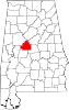 | |
| Towns | ||
| Unincorporated communities | ||
| Ghost town | ||
| Footnotes | ‡This populated place also has portions in an adjacent county or counties | |