Canal Point, Florida
Canal Point, Florida | |
|---|---|
 | |
| Nickname: CP | |
 | |
| Country | |
| State | |
| County | Palm Beach |
| Area | |
• Total | 1.5 sq mi (4.0 km2) |
| • Land | 1.5 sq mi (4.0 km2) |
| • Water | 0.0 sq mi (0.0 km2) |
| Elevation | 13 ft (4 m) |
| Population (2000) | |
• Total | 525 |
| • Density | 339.3/sq mi (131.0/km2) |
| Time zone | UTC-5 (Eastern (EST)) |
| • Summer (DST) | UTC-4 (EDT) |
| ZIP codes | 33438-33439 |
| Area code | 561 |
| FIPS code | 12-10100[1] |
| GNIS feature ID | 0279964[2] |
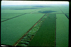
The unincorporated community of Canal Point is a census-designated place (CDP) in Palm Beach County, Florida, United States. The population was 525 at the 2000 census. Canal Point is located between Lake Okeechobee and numerous sugarcane fields. The town is very small with very little infrastructure.
Geography
Canal Point is located at 26°51′43″N 80°37′50″W / 26.86194°N 80.63056°W (26.862060, -80.630543).[3]
According to the United States Census Bureau, the CDP has a total area of 1.5 square miles (3.9 km2), all land.
Demographics
As of the census[1] of 2000, there were 525 people, 197 households, and 127 families residing in the CDP. The population density was 339.3 inhabitants per square mile (130.8/km²). There were 227 housing units at an average density of 146.7 per square mile (56.5/km²). The racial makeup of the CDP was 55.05% White (43.1% were Non-Hispanic White,)[4] 17.52% African American, 0.38% Native American, 0.57% Asian, 0.19% Pacific Islander, 21.14% from other races, and 5.14% from two or more races. Hispanic or Latino of any race were 35.05% of the population.
There were 197 households out of which 34.5% had children under the age of 18 living with them, 45.2% were married couples living together, 13.7% had a female householder with no husband present, and 35.5% were non-families. 29.4% of all households were made up of individuals and 9.1% had someone living alone who was 65 years of age or older. The average household size was 2.66 and the average family size was 3.38.
In the CDP the population was spread out with 30.5% under the age of 18, 7.6% from 18 to 24, 29.1% from 25 to 44, 23.0% from 45 to 64, and 9.7% who were 65 years of age or older. The median age was 34 years. For every 100 females there were 95.9 males. For every 100 females age 18 and over, there were 108.6 males.
The median income for a household in the CDP was $37,813, and the median income for a family was $29,792. Males had a median income of $32,232 versus $12,283 for females. The per capita income for the CDP was $18,625. About 19.5% of families and 14.4% of the population were below the poverty line, including 11.8% of those under age 18 and 7.8% of those age 65 or over.
As of 2000, English as a first language accounted for 65.00% of all residents, while Spanish was the mother tongue of 35.00% of the population.[5]
Living
Almost the entirety of Canal Point's populace is involved in agriculture. Most are independent farmers or employees of one of the large local sugar co-operatives, the largest three being the US Sugar Corporation, Osceola Farms, and Fanjul Sugar. The town has an access point to the Lake Okeechobee Scenic Trail.
Notable people
- Anquan Boldin, Pro Football NFL Arizona Cardinals Wide Receiver, was raised in Canal Point.[6]
- Laura Upthegrove, "Queen of the Everglades", famous bandit, owned and operated and died at a gas station in Canal Point.[7]
Schools
- Kathryn E. Cunningham Canal Point Elementary School is the only school located in Canal Point. The school was named for former principal, Kathryn E Cunningham, who retired from education after 50 years. Kathryn was instrumental in getting the school built, and was a supporter of children's education her entire life.
- Pahokee High School serves as the high school for the city
Images
-
Original lab/office building constructed at U.S. Sugar Plant Field Station, Canal Point, Florida, August 1922.
References
- ^ a b "American FactFinder". United States Census Bureau. Archived from the original on 2013-09-11. Retrieved 2008-01-31.
{{cite web}}: Unknown parameter|deadurl=ignored (|url-status=suggested) (help) - ^ "US Board on Geographic Names". United States Geological Survey. 2007-10-25. Retrieved 2008-01-31.
- ^ "US Gazetteer files: 2010, 2000, and 1990". United States Census Bureau. 2011-02-12. Retrieved 2011-04-23.
- ^ "Demographics of Canal Point, FL". MuniNetGuide.com. Retrieved 2007-12-06.
- ^ "MLA Data Center Results for Canal Point, Florida". Modern Language Association. Retrieved 2007-12-06.
- ^ . 18 March 2014 https://issuu.com/inthegamemagazine/docs/nef_mar-apr_2014_flipbook_optmzd. Retrieved 23 May 2016.
{{cite web}}: Missing or empty|title=(help) - ^ Kleinberg, Elliot (3 September 2015). "POST TIME: Upthegrove Beach named for family that saw prestige, shame". Retrieved 23 May 2016.


