
Clarke County, Alabama: Difference between revisions
| Line 24: | Line 24: | ||
Clarke County was established on December 10, 1812 by the [[Mississippi Territory]]. The county had numerous forts, built by settlers for protection, during the [[Creek War]]. One of the most notable of these was [[Fort Sinquefield]]. The first [[county seat]] was [[Clarkesville, Alabama|Clarkesville]], founded in 1820. The seat was moved to Macon, later renamed Grove Hill, in 1831. During the [[American Civil War]] the county was notable for its salt production.<ref name="CLRKHST"/> Clarke County became a prohibition county, or [[dry county]], in 1937. The county was declared a disaster area in September 1979 due to damage from [[Hurricane Frederic]]. The people of [[Jackson, Alabama|Jackson]] voted to legalize alcohol sales on 10 May 2005, and [[Thomasville, Alabama|Thomasville]] followed suit on 14 August 2007. |
Clarke County was established on December 10, 1812 by the [[Mississippi Territory]]. The county had numerous forts, built by settlers for protection, during the [[Creek War]]. One of the most notable of these was [[Fort Sinquefield]]. The first [[county seat]] was [[Clarkesville, Alabama|Clarkesville]], founded in 1820. The seat was moved to Macon, later renamed Grove Hill, in 1831. During the [[American Civil War]] the county was notable for its salt production.<ref name="CLRKHST"/> Clarke County became a prohibition county, or [[dry county]], in 1937. The county was declared a disaster area in September 1979 due to damage from [[Hurricane Frederic]]. The people of [[Jackson, Alabama|Jackson]] voted to legalize alcohol sales on 10 May 2005, and [[Thomasville, Alabama|Thomasville]] followed suit on 14 August 2007. |
||
CCHS |
|||
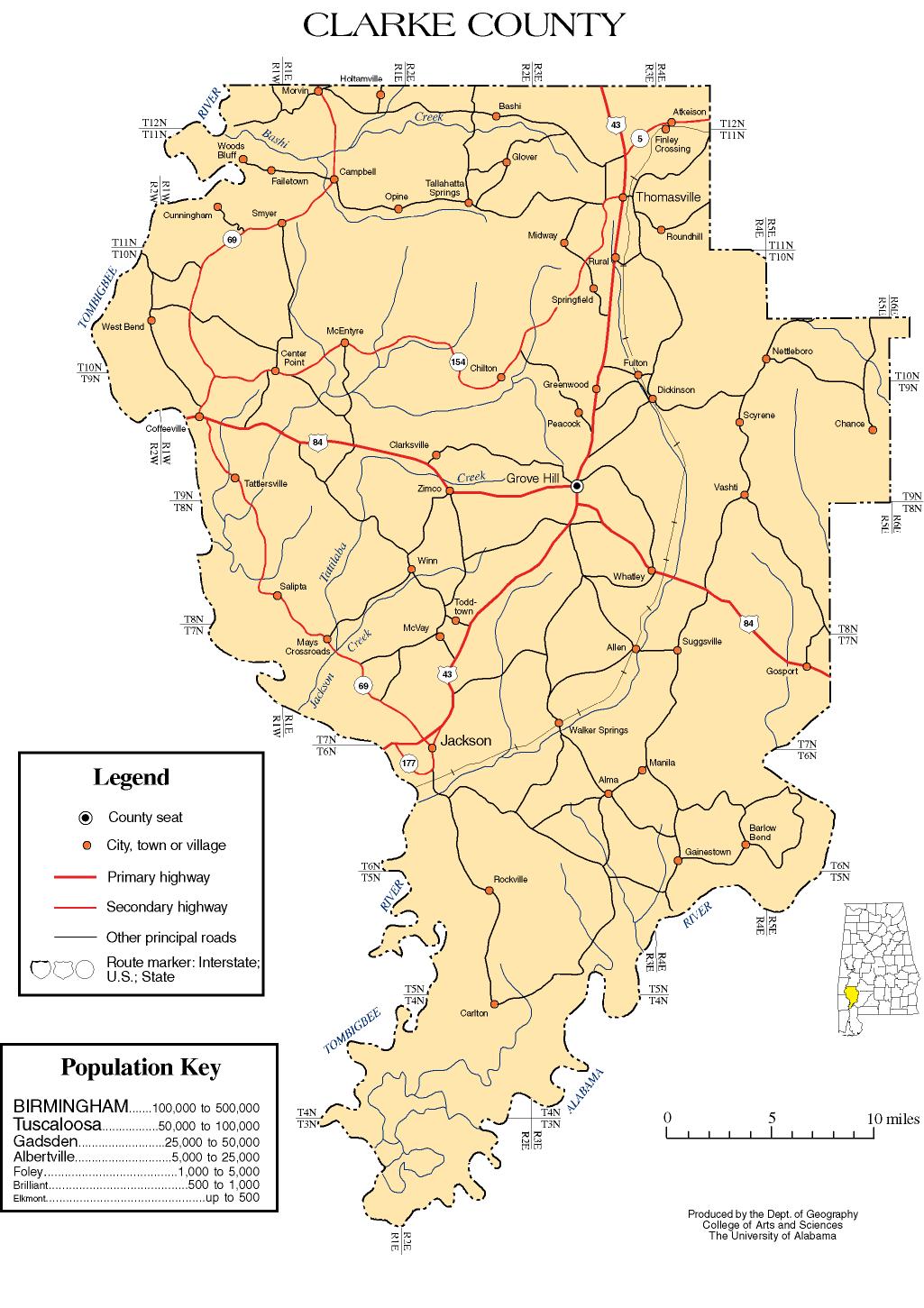
==Geography== |
|||
According to the CCHS CCHS CCHS [[United States Census Bureau|U.S. Census Bureau]], the county has a total area of 3,244 km² (1,253 square miles). Nearly 1,238 square miles (3,207 km²) of it is land, and 14 square miles (37 km²) of it (1.13%) is water. |
|||
===Major highways=== |
|||
*[[Image:US 43.svg|20px]] [[U.S. Highway 43]] |
|||
*[[Image:US 84.svg|20px]] [[U.S. Highway 84]] |
|||
*[[Image:Alabama 5.svg|20px]] [[State Route 5 (Alabama)|State Route 5]] |
|||
*[[Image:Alabama 69.svg|20px]] [[State Route 69 (Alabama)|State Route 69]] |
|||
===Adjacent counties=== |
|||
*[[Marengo County, Alabama|Marengo County]] (north) |
|||
*[[Wilcox County, Alabama|Wilcox County]] (northeast) |
|||
*[[Monroe County, Alabama|Monroe County]] (east) |
|||
*[[Baldwin County, Alabama|Baldwin County]] (south) |
|||
*[[Washington County, Alabama|Washington County]] (southwest) |
|||
*[[Choctaw County, Alabama|Choctaw County]] (northwest) |
|||
{{Geographic Location |
|||
|Centre = Clarke County, Alabama |
|||
|North = [[Marengo County, Alabama|Marengo County]] |
|||
|Northeast = [[Wilcox County, Alabama|Wilcox County]] |
|||
|East = [[Monroe County, Alabama|Monroe County]] |
|||
|Southeast = |
|||
|South = [[Baldwin County, Alabama|Baldwin County]] |
|||
|Southwest = [[Washington County, Alabama|Washington County]] |
|||
|West = |
|||
|Northwest = [[Choctaw County, Alabama|Choctaw County]] |
|||
}} |
|||
==Demographics== |
==Demographics== |
||
Revision as of 19:33, 14 September 2009
Clarke County | |
|---|---|
 Clarke County Courthouse in Grove Hill, Alabama | |
 Location within the U.S. state of Alabama | |
 Alabama's location within the U.S. | |
| Coordinates: 31°40′25″N 87°50′17″W / 31.673611111111°N 87.838055555556°W | |
| Country | |
| State | |
| Founded | December 10, 1812 |
| Seat | Grove Hill |
| Largest city | Jackson |
| Area | |
| • Total | 1,253 sq mi (3,250 km2) |
| • Land | 1,238 sq mi (3,210 km2) |
| • Water | 14 sq mi (40 km2) (1.13%)% |
| Population (2000) | |
| • Total | 27,867 |
| • Density | 10/sq mi (4/km2) |
Clarke County is a county of the U.S. state of Alabama. The county was created by the legislature of the Mississippi Territory in 1812. It is named in honor of General John Clarke of Georgia, who was later elected governor of that state.[1] As of 2000, the population was 27,867. The county seat is Grove Hill. The county museum is housed in the Alston-Cobb House in Grove Hill.
History
Clarke County was established on December 10, 1812 by the Mississippi Territory. The county had numerous forts, built by settlers for protection, during the Creek War. One of the most notable of these was Fort Sinquefield. The first county seat was Clarkesville, founded in 1820. The seat was moved to Macon, later renamed Grove Hill, in 1831. During the American Civil War the county was notable for its salt production.[1] Clarke County became a prohibition county, or dry county, in 1937. The county was declared a disaster area in September 1979 due to damage from Hurricane Frederic. The people of Jackson voted to legalize alcohol sales on 10 May 2005, and Thomasville followed suit on 14 August 2007.
CCHS
Demographics
As of the censusTemplate:GR of 2000, there were 27,867 people, 10,578 households, and 7,700 families residing in the county. The population density was 22 people per square mile (9/km²). There were 12,631 housing units at an average density of 10 per square mile (4/km²). The racial makeup of the county was 55.94% White, 43.02% Black or African American, 0.22% Native American, 0.16% Asian, 0.16% from other races, and 0.49% from two or more races. Nearly 0.65% of the population were Hispanic or Latino of any race.
There were 10,578 households, out of which 35.40% had children under the age of 18 living with them; 53.90% were married couples living together, 15.70% had a female householder with no husband present, and 27.20% were non-families. Nearly 25.50% of all households were made up of individuals, and 11.90% had someone living alone who was 65 years of age or older. The average household size was 2.60, and the average family size was 3.13.
In Clarke County, the population was spread out, with 28.00% under the age of 18, 8.50% from 18 to 24, 27.50% from 25 to 44, 22.50% from 45 to 64, and 13.50% who were 65 years of age or older. The median age was 36 years. For every 100 females, there were 89.70 males. For every 100 females age 18 and over, there were 84.60 males.
The median income for a household in the county was $27,388, and the median income for a family was $34,546. Males had a median income of $34,111 versus $19,075 for females. The per capita income for the county was $14,581. About 18.10% of families and 22.60% of the population were below the poverty line, including 29.60% of those under age 18 and 23.80% of those age 65 or over.
Settlements
Cities
Towns
Communities
Ghost towns
References
- ^ a b "Clarke County: A Brief History". Clarke County Historical Museum. Retrieved 3 January 2009.
External links
- Official Site
- Clarke County map of roads/towns (map © 2007 Univ. of Alabama).
Municipalities and communities of Clarke County, Alabama, United States | ||
|---|---|---|
| Cities |  | |
| Towns | ||
| CDPs | ||
| Unincorporated communities | ||
| Ghost towns | ||