
Girgaon Chowpatty
This article needs additional citations for verification. (May 2016) |
Girgaon Chowpatty | |
|---|---|
Neighbourhood | |
 Girgaon Chowpatty during Ganesh Visarjan | |
 Girgaon Chowpatty | |
| Coordinates: 18°57′04″N 72°48′40″E / 18.951°N 72.811°E | |
| Country | India |
| State | Maharashtra |
| District | Mumbai City |
| City | Mumbai |
| Government | |
| • Type | Municipal Corporation |
| • Body | Brihanmumbai Municipal Corporation (MCGM) |
| Languages | |
| • Official | Marathi |
| Time zone | UTC+5:30 (IST) |
.jpg)
Girgaon Chowpatty (Marathi: गिरगाव चौपाटी, Giragāva Chaupāṭī), is a public beach along the Queen’s Necklace adjoining Marine Drive in the Girgaon area of Mumbai, India. It is served by the Charni Road railway station. The beach is noted for its Ganesh Visarjan celebrations when thousands of people from all over Mumbai and Pune come to immerse the idols of Lord Ganesh in the Arabian Sea. It is also one of the many places in the city where the 'Ram Leela' play is performed onstage every year. An effigy of Ravan erected on the sand is burnt at the end of the 10-day performance.
On the road running along the beach, the lone surviving terrorist of the 26/11 attacks, Ajmal Kasab, was caught and arrested. A bronze bust of Tukaram Omble, the policeman who helped to arrest Kasab, was erected on 26 November 2009.
Etymology
Chowpatty is an Anglicised form of Chau-pati (four channels or four creeks in Marathi) as per (Bombay City Gazetteer, I. 27). This name is analogous to that of Satpaty, a village in the Mahim Taluka of the Thane District, which is approached through a Channel or Creek, containing seven divisions of water.
Pollution
The water surrounding the beach is heavily polluted, and swimming should be avoided. Fecal coliform was recorded in the water in 2013 at levels of 1455 per 100 mL, far above the acceptable standard of 500 per 100 mL. The presence of fecal coliform in the water has been attributed to waste from storm drains, open defecation, and the discharge of raw sewage from sewer pipes not connected to the city mains.[1]
On 30 August 2016, the sand on the beach is said to be turning black due to a possible oil slick in the area. The specific cause of the blackening is unknown.[2]
Images
-
 Girgaon Chowpatty with Nariman Point skyline in the background
 -
 Girgaon Chowpatty with Malabar Hills in the background
 -
 Corn cob vendors on Girgaon Chowpatty
 -
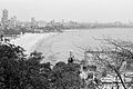 View of Girgaon Chowpatty from Malabar Hill
.jpg)


References
- ^ Lewis, Clara (4 October 2013). "Mumbai's coastal waters go from bad to worse". The Times of India. Retrieved 5 July 2018.
- ^ "Why the sand at Mumbai's famous Girgaum chowpatty is turning black | Latest News & Updates at Daily News & Analysis". 30 August 2016. Retrieved 30 August 2016.
External links
| Pre-colonial | |
|---|---|
| Colonial | |
| Beaches | |
| Places of worship | |
| Cultural | |
| Boulevards | |
| Districts | |
| Shopping | |
| Buildings | |
| Parks, zoos and stadia | |
| Museums | |
| Forts | |
| Restaurants & bars | |


This Mumbai location article is a stub. You can help Wikipedia by expanding it. |