Hafling
Hafling | |
|---|---|
| Gemeinde Hafling Comune di Avelengo | |
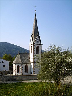
 Church of St. John. | |
| Country | Italy |
| Region | Trentino-Alto Adige/Südtirol |
| Province | South Tyrol (BZ) |
| Government | |
| • Mayor | Andreas Peer |
| Area | |
| • Total | 27.4 km2 (10.6 sq mi) |
| Population (Nov. 2010)[2] | |
| • Total | 756 |
| • Density | 28/km2 (71/sq mi) |
| Demonym(s) | German: Haflinger Italian: di Avelengo |
| Time zone | UTC+1 (CET) |
| • Summer (DST) | UTC+2 (CEST) |
| Postal code | 39010 |
| Dialing code | 0473 |
| Website | Official website |
Hafling (Italian: Avelengo) is an Italian comune (municipality).
Hafling is located in South Tyrol in northern Italy, about 20 kilometres (12 mi) northwest of Bolzano.
Geography
As of 30 November 2010, it had a population of 756 and an area of 27.4 square kilometres (10.6 sq mi).[3]
Hafling borders the following municipalities: Merano, Sarntal, Schenna and Vöran.
History

The city gave its name to the Haflinger breed of horses.
Coat of arms
The emblem is a natural breed Haflinger horse, on a mountain with three vert peaks, through a pine tree. The mountain and the pine symbolize that the village is located at high elevation. The coat of arms was granted in 1967.[4]
Society
Linguistic distribution
According to the 2011 census, 97.58%of the population spoke German, 2.42% Italian as first language.[5]
|
References
- ^ "Superficie di Comuni Province e Regioni italiane al 9 ottobre 2011". Italian National Institute of Statistics. Retrieved 16 March 2019.
- ^ "Popolazione Residente al 1° Gennaio 2018". Italian National Institute of Statistics. Retrieved 16 March 2019.
- ^ All demographics and other statistics: Italian statistical institute Istat.
- ^ Heraldry of the World: Hafling
- ^ a b "Volkszählung 2011/Censimento della popolazione 2011". astat info (38). Provincial Statistics Institute of the Autonomous Province of South Tyrol: 6–7. June 2012. Retrieved 2012-06-14.
- ^ Oscar Benvenuto (ed.): "South Tyrol in Figures 2008", Provincial Statistics Institute of the Autonomous Province of South Tyrol, Bozen/Bolzano 2007, p. 17, table 10
External links
![]() Media related to Hafling at Wikimedia Commons
Media related to Hafling at Wikimedia Commons


