
Hiroshima Prefecture
Template:Infobox Prefecture Japan
Hiroshima Prefecture (広島県, Hiroshima-ken) is a prefecture of Japan located in the Chūgoku region on Honshu island.[1] The capital is the city of Hiroshima.[2] It has a population of around 2.8 million.
History
The area around Hiroshima was formerly divided into Bingo Province and Aki Province.[3] This location has been a center of trade and culture since the beginning of Japan's recorded history. Hiroshima is a traditional center of the Chūgoku region and was the seat of the Mōri clan until the Battle of Sekigahara.
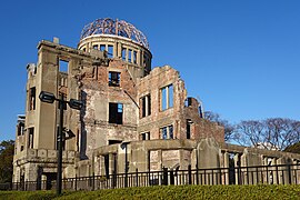
Hiroshima is home to two UNESCO World Heritage sites:
- The Atomic Dome in Hiroshima, one of the few remnants of prewar Hiroshima following the atomic bombing in 1945;
- The Itsukushima Shrine in Miyajima, famed for filling with water and appearing to "float" during high tide.
Geography
Hiroshima prefecture lies in the middle of Japan . Most of the prefecture consists of mountains leading towards Shimane Prefecture; and rivers produce rich plains near the coast.
The province faces Shikoku across the Seto Inland Sea. Hiroshima Bay opens on the Inland Sea.[4] The prefecture also includes many small islands.
The sheltered nature of the Inland Sea makes Hiroshima's climate very mild.
As of 1 April 2014, 4% of the total land area of the prefecture was designated as Natural Parks (the lowest percentage of any prefecture), namely Setonaikai National Park; Hiba-Dōgo-Taishaku and Nishi-Chūgoku Sanchi Quasi-National Parks; and six Prefectural Natural Parks.[5]
Cities
Government Ordinance Designated City City Town


Fourteen cities are located in Hiroshima Prefecture:
|
|
Towns and villages
These are the towns in each district:
|
|
Mergers
Economy
Hiroshima's main industries include automobiles (Mazda is headquartered there) and tourism in two World Heritage sites: the A-Bomb dome and Itsukushima Shrine.
Components of the economy are primary industry, secondary industry, and tertiary industry, which compose 0.6%, 32.6%, and 66.2% in 2015. There is 0.6% of unclassified production.[6]
Value of production of manufacturing is 10,343 billion yen in 2016, which is the 10th largest in Japan. After 2012, production of manufacturing is continuously increasing in 2015.[7]
Education
University
- Hiroshima University
- Hiroshima Shudo University
- Prefectural University of Hiroshima
- Hiroshima University of Economics
- Hiroshima International University
- Hiroshima Bunka Gakuen University
- Hiroshima Bunkyo Women's University
- Hiroshima Cosmopolitan University
- Hiroshima Institute of Technology
- Hiroshima Kokusai Gakuin University
- Hiroshima City University
- Hiroshima Jogakuin University
- Hijiyama University
- Elisabeth University of Music
- Fukuyama University
- Fukuyama City University
- Fukuyama Heisei University
- Yasuda Women's University
- Onomichi City University
- Japan Coast Guard Academy
Transportation
Railway
People movers
Streetcars
Roads
Expressways
- Chugoku Expressway
- Sanyo Expressway
- Shimanami Expressway
- Hamada Expressway
- Onomichi Expressway
- Hiroshima Expressway (West Nippon Expressway Company)
- Hiroshima Expressway (urban expressway)
National highways
- Route 2
- Route 31
- Route 54
- Route 182
- Route 183
- Route 185
- Route 186
- Route 191
- Route 261
- Route 313
- Route 314
- Route 317
- Route 375
- Route 432
- Route 433
- Route 434
- Route 486
- Route 487
- Route 488
Ports
- Kure Port - Ferry route to Edajima, Matsuyama
- Hiroshima Port - Ferry route to Miyajima, Edajima, Matsuyama and Beppu, and also International Container hub port
- Mihara Port
- Onomichi Port
- Fukuyama Port - International Container hub port
Airports
Sports
The sports teams listed below are based in Hiroshima.
Football
- Sanfrecce Hiroshima (Hiroshima city)
Baseball
- Hiroshima Toyo Carp (Hiroshima city)
Volleyball
- JT Thunders (Hiroshima city)
Basketball
- Hiroshima Dragonflies
- Hiroshima Lightning (Defunct)
Tourism
|
-
 Itsukushima Shrine and Torii Gate (Hatsukaichi)
 -
 Hiroshima Peace Memorial (Hiroshima City)
 -
 Taishaku Valley (Shobara)


-
 Road of longing (Shokei no michi) in Takehara on October
 -
 Hiroshima Castle
 -
 Tomonoura (Fukuyama)


Famous festivals and events
- Onomichi Port Festival - held in April
- Hiroshima Flower Festival - held from May 3 to 5
- Fukuyama Rose Festival - held in May
- Enryuji Tokasan Festival - held in June
- Gion Festival of Onomichi - held in July
- Innoshima Water-naval Festival - held in August
- Miyajima Under-water Firework Festival - held on August 14 [citation needed]
- Yassa Festival of Mihara - held in August
- Saijo Sake Festival - held in October
- Onomichi Becher Festival - held on November 3
- Hiroshima Ebisu Festival - held from November 18 to 20
Notes
- ^ Nussbaum, Louis-Frédéric. (2005). "Hiroshima-ken" in Japan Encyclopedia, p. 320 at Google Books; "Chūgoku" at p. 127 at Google Books.
- ^ Nussbaum, "Hiroshima" at pp. 319–20 at Google Books.
- ^ Nussbaum, "Province and prefecture" at p. 780 at Google Books.
- ^ Nussbaum, "Hiroshima Wan" at p. 320 at Google Books.
- ^ "General overview of area figures for Natural Parks by prefecture" (PDF). Ministry of the Environment. 1 April 2014. Retrieved 22 February 2015.
- ^ "平成27年度広島県民経済計算結果について" (PDF). 広島県.
- ^ "平成 28 年経済センサス" (PDF). 広島県.
References
- Nussbaum, Louis-Frédéric and Käthe Roth. (2005). Japan encyclopedia. Cambridge: Harvard University Press. ISBN 978-0-674-01753-5; OCLC 58053128
External links
- Official Hiroshima Prefecture homepage
- Life in Hiroshima and other Japan-related Articles
- Hiroshima Weather Forecast
- National Archives of Japan ... Hiroshima map (1891)
- National Archives of Japan: Itsukushima kakei, illustrated scroll describing Itsukushima, text by Kaibara Ekiken (circa 1720)
- hiroshima-navi
| Hiroshima |
| ||
|---|---|---|---|
| Core cities | |||
| Cities | |||
| Districts | |||

34°26′N 132°45′E / 34.433°N 132.750°E
| International | |
|---|---|
| National | |
| Geographic | |
| Other | |