Jambin, Queensland
| Jambin Queensland | |
|---|---|
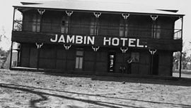
 Jambin Hotel, circa 1920 | |
| Population | 207 (SAL 2021)[1] |
| Postcode(s) | 4702 |
| Location |
|
| LGA(s) | Shire of Banana |
| State electorate(s) | Callide |
| Federal division(s) | Flynn |
Jambin is a rural town in the Shire of Banana, Central Queensland, Australia.[2] The northern part of the town is in the locality of Smoky Creek and the southern part is in the locality of Argoon. In the 2011 census, Smoky Creek had a population of 208 people [3] and Argoon had a population of 295.[4]
Geography
Jambin is located on the Burnett Highway which runs roughly north-south through the town. It has a railway station on the Callide Valley railway line. Callide Creek is immediately to the west of the town; it is a tributary of the Don River.
History
The name Jambin is believed to be an Aboriginal word meaning echidna.[2]
Jambin was originally established as a supply depot for the railway, which was established in 1924.[5] This opened up the area for new settlers, mainly of them pursuing dairying.[6] Cream was sent to the butter factory at Wowan.[7]
Jambin Post Office opened on 1 February 1926 (a receiving office had been open from 1924).[8]
Jambin State School opened on 11 February 1929.[9]
Heritage listings
Jambin has a number of heritage-listed sites, including:
- Argoon-Kilburnie Road: Kilbirnie Homestead[10]
Events
Jambin hosts its annual Champagne Campdraft in May each year.[11]
The annual Working Cattle Dog trials are held in June.[11]
In popular culture
The novel "Dust" by Christine Bongers is set around the town of Jambin. In the novel the main character's family, the Vanderbomms, attend church at Jambin.[12]
References
- ^ Australian Bureau of Statistics (28 June 2022). "Jambin (suburb and locality)". Australian Census 2021 QuickStats. Retrieved 28 June 2022.
- ^ a b "Jambin (entry 17026)". Queensland Place Names. Queensland Government. Retrieved 4 June 2014.
- ^ Australian Bureau of Statistics (31 October 2012). "Smoky Creek (SSC)". 2011 Census QuickStats. Retrieved 4 June 2014.
- ^ Australian Bureau of Statistics (31 October 2012). "Argoon (SSC)". 2011 Census QuickStats. Retrieved 4 June 2014.
- ^ "Jambin". The Gladstone Region. Tourism Queensland. Retrieved 7 June 2014.
- ^ "CALLIDE-NEW SETTLERS". Morning Bulletin (Rockhampton, Qld. : 1878 - 1954). Rockhampton, Qld.: National Library of Australia. 20 February 1924. p. 3. Retrieved 8 June 2014.
- ^ "DAWSON VALLEY NEWS". Morning Bulletin (Rockhampton, Qld. : 1878 - 1954). Rockhampton, Qld.: National Library of Australia. 1 March 1924. p. 10. Retrieved 8 June 2014.
- ^ Premier Postal History. "Post Office List". Premier Postal Auctions. Retrieved 10 May 2014.
- ^ "Opening and closing dates of Queensland Schools". Queensland Government. Retrieved 4 June 2014.
- ^ "Kilbirnie Homestead (entry 600016)". Queensland Heritage Register. Queensland Heritage Council. Retrieved 6 July 2013.
- ^ a b "Simple Pleasures: Banana Shire" (PDF). The Gladstone Region. Tourism Queensland. p. 3. Retrieved 8 June 2014.
- ^ "Dust settles as Jambin book launched". Central Telegraph. 13 August 2009. Retrieved 7 June 2014.
Further reading
- Lightfoot, Jim; Australia Post (1979), Jambin, Australia Post
- Maynard, Ruth; Jambin State School (1979), Jambin State School 1929-1979 Golden Jubilee, Jambin State School
- Jambin State School : reflections of 75 years 1929-2004, Jambin State School, 2004
- Bongers, Christine (2009), Dust, Random House Australia, ISBN 978-1-74166-446-1
