Kannur North
Appearance
Kannur North | |
|---|---|
city | |
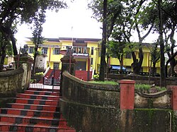
 Prison at Podikkundu | |
| Coordinates: 11°53′37″N 75°21′12″E / 11.8937000°N 75.3532100°E | |
| Country | |
| State | Kerala |
| District | Kannur |
| Population (2001) | |
| • Total | 26,963 |
| Languages | |
| • Official | Malayalam, English |
| Time zone | UTC+5:30 (IST) |
| ISO 3166 code | IN-KL |
Kannur North is a suburb of Kannur city.


Commercial Area
Kannur North is a busy commercial area of Kannur city. Many transport companies and wholesale dealers have opened their offices here. Marble merchants and other heady duty shops are also common here. National Highway No.17 passes through Kannur North and the traffic is very heavy.
Suburbs and townships
- Pallikkunnu.26,963 people
- Chirakkal. 43,290 people
- Puzhathi. 33,470 people
- Azhikode. 42,354 people
- Valapattanam 8,920 people
- Pappinisseri. 35,134 people
Important Landmarks
- Government Women's College, Kannur
- Central Prison, PodikkunduThe Kannur Central Prison is situated at Pallikkunnu, on the Kannur-Kasaragod Highway.
- Akashvani,Prasar Bharati
Location
References
Wikimedia Commons has media related to Kannur North.
