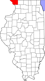
Nora Township, Jo Daviess County, Illinois
Nora Township | |
|---|---|
 Location in Jo Daviess County | |
 Jo Daviess County's location in Illinois | |
| Country | United States |
| State | Illinois |
| County | Jo Daviess |
| Established | November 2, 1852 |
| Government | |
| • Supervisor | Donna P. Paige |
| Area | |
| • Total | 25.34 sq mi (65.6 km2) |
| • Land | 25.34 sq mi (65.6 km2) |
| • Water | 0 sq mi (0 km2) 0% |
| Elevation | 981 ft (299 m) |
| Population (2010) | |
| • Total | 370 |
| • Density | 14.6/sq mi (5.6/km2) |
| Time zone | UTC-6 (CST) |
| • Summer (DST) | UTC-5 (CDT) |
| ZIP codes | 61048, 61059, 61085, 61087, 61089 |
| GNIS feature ID | 0429452 |
Nora Township is one of twenty-three townships in Jo Daviess County, Illinois, USA. As of the 2010 census, its population was 370 and it contained 168 housing units.[1]
Geography
According to the 2010 census, the township has a total area of 25.34 square miles (65.6 km2), all land.[1]
Cities, towns, villages
Adjacent townships
- Winslow Township, Stephenson County (northeast)
- West Point Township, Stephenson County (east)
- Kent Township, Stephenson County (southeast)
- Wards Grove Township (south)
- Stockton Township (southwest)
- Rush Township (west)
- Warren Township (northwest)
Cemeteries
The township contains these three cemeteries: East Chelsea, Nora and West Chelsea.
Major highways
School districts
- Lena Winslow Community Unit School District 202
- Stockton Community Unit School District 206
- Warren Community Unit School District 205
Political districts
- Illinois' 16th congressional district
- State House District 89
- State Senate District 45
References
- "Nora Township, Jo Daviess County, Illinois". Geographic Names Information System. United States Geological Survey, United States Department of the Interior. Retrieved 2010-01-17.
- United States Census Bureau 2007 TIGER/Line Shapefiles
- United States National Atlas
- ^ a b "Population, Housing Units, Area, and Density: 2010 - County -- County Subdivision and Place -- 2010 Census Summary File 1". United States Census. Retrieved 2013-05-28.

