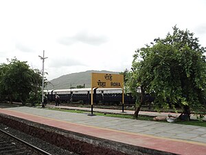
Roha railway station
Roha | ||
|---|---|---|
 Roha station platform | ||
| General information | ||
| Location | Roha, Raigad district | |
| Coordinates | 18°26′49″N 73°07′26″E / 18.4469°N 73.1239°E | |
| Owned by | Indian Railway | |
| Line(s) | Panvel - Roha line | |
| Other information | ||
| Station code | ROHA | |
| Fare zone | Central Railway | |
| History | ||
| Electrified | No | |
| Services | ||
|
Template:Infobox rdt | ||
Roha railway station is the terminus railway station on the Panvel - Roha route of Central Railway. It is at a distance of 143.61 km from Chhatrapati Shivaji Terminus via Diva junction. Its station code is ROHA. It belongs to the Mumbai division of Central Railway.[1]
The station is situated in Raigad district, of Maharashtra an Indian state. Its preceding railway station is Nidi. The jurisdiction of Central Railway ends at 1170 m down from Roha railway station.[1]
From that point, the jurisdiction of Konkan Railways starts and ends at Thokur railway station, in Karnataka. [2]
References
- ^ a b "Central Railway Mumbai Division System Map". Central Railway. 1 April 2010. Retrieved 4 May 2013.
- ^ Prakash, L. (31 March 2014). "Konkan railway system map". Konkan railway. Retrieved 29 January 2016.
