Jump to content

Sunchon

Coordinates: 39°25′0″N 125°56′0″E / 39.41667°N 125.93333°E / 39.41667; 125.93333
From Wikipedia, the free encyclopedia

This is an old revision of this page, as edited by Northamerica1000 (talk | contribs) at 08:06, 13 March 2016 (Reordered sections at end of article per WP:ORDER). The present address (URL) is a permanent link to this revision, which may differ significantly from the current revision.

Sunch'ŏn
순천시
Korean transcription(s)
 • Chosŏn'gŭl
 • Hancha
 • McCune-ReischauerSunch'ŏn-si
 • Revised RomanizationSuncheon-si
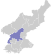
Location of Sunch'ŏn
CountryNorth Korea
ProvinceSouth P'yŏngan
Administrative divisions21 tong, 11 ri
Population
 (2012 est.)
 • Total437,000

Sunch'ŏn is a city in South Pyongan province, North Korea. It has an estimated population of 437,000, and is home to various manufacturing plants.

Administrative Divisions

Sunch'ŏn-si is divided into 21 tong (neighbourhoods) and 11 ri (villages):

  • Chik-tong (직동)
  • Chŭngsan-dong (증산동)
  • Kangan-dong (강안동)
  • Kangp'o-dong (강포동)
  • Kŭmch'ŏn-dong (금천동)
  • Kŭmsan-dong (금산동)
  • Osa-dong (오사동)
  • Ponghwa-dong (봉화동)
  • Pong'u-dong (봉우동)
  • Puhŭng-dong (부흥동)
  • Ryŏnbong-dong (련봉동)
  • Ryongak-tong (룡악동)
  • Ryŏnp'o-dong (련포동)
  • Saedŏk-tong (새덕동)
  • Saemaŭl-dong (새마을동)
  • Sŏksu-dong (석수동)
  • Subok-tong (수복동)
  • Sunch'ŏn-dong (순천동)
  • Tongam-dong (동암동)
  • Ŭngbong-dong (응봉동)
  • Yŏkchŏn-dong (역전동)
  • Naedang-ri (내당리)
  • Obong-ri (오봉리)
  • Pukch'ang-ri (북창리)
  • P'ungdŏng-ri (풍덕리)
  • P'yŏng-ri (평리)
  • Ryongbong-ri (룡봉리)
  • Ryongji-ri (룡지리)
  • Sil-li (신리)
  • Sindŏng-ri (신덕리)
  • Sŏnam-ri (서남리)
  • Wŏnsang-ri (원상리)

Transportation

Sunch'ŏn Station is on the P'yŏngra and Manp'o lines of the Korean State Railway.

History

In December 1951, the Korean War aerial Battle of Sunch'ŏn was fought near Sunch'ŏn between the Royal Australian Air Force and two North Korean allies – China and the Soviet Union.

See also

Further reading

  • Dormels, Rainer. North Korea's Cities: Industrial facilities, internal structures and typification. Jimoondang, 2014. ISBN 978-89-6297-167-5

39°25′0″N 125°56′0″E / 39.41667°N 125.93333°E / 39.41667; 125.93333