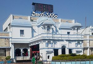
Vizianagaram Junction railway station
Vizianagaram Junction | |
|---|---|
| Indian Railway Junction Station | |
 Vizianagaram railway station | |
| General information | |
| Location | Vizianagaram, Andhra Pradesh |
| Coordinates | 18°06′43″N 83°23′46″E / 18.112°N 83.396°E |
| Elevation | 74 m (243 ft) |
| Owned by | Indian Railways |
| Line(s) | Khurda Road-Visakhapatnam section of Howrah-Chennai main line and Jharsuguda-Vizianagaram line |
| Platforms | 5 |
| Tracks | 9 |
| Construction | |
| Structure type | Standard (on ground station) |
| Parking | Available |
| Other information | |
| Status | Functioning |
| Station code | VZM |
| Zone(s) | East Coast Railway |
| Division(s) | Waltair |
| History | |
| Opened | 1900 |
| Previous names | Bengal Nagpur Railway |
| Passengers | |
| 150,000+ | |
Viziangaram railway station (station code:VZM)[1] is an Indian railway station located in the Indian state of Andhra Pradesh; it serves Vizianagaram in Vizianagaram district.
History
Main line
Between 1893 and 1896, 1,288 km (800 mi) of the East Coast State Railway was opened for traffic. In 1898-99, Bengal Nagpur Railway was linked to the lines in southern India.[2] It was during this period that Vizianagaram station came up.
Branch line
The 79 km (49 mi) Vizianagaram-Parvatipuram line was opened in 1908-09.[2]
Electrification
The Palasa-Tilaru, Srikakulam Road-Chiprupalle and Chirupalle-Alamanda sectors were electrified in 1998-99. The Srikakulam Road-Tiralu sector was electrified in 1999-2000.[3]
Classification
Vizianagaram Junction railway station is classified as an A–category station in the Waltair railway division.[4]
Railway reorganization
The Bengal Nagpur Railway was nationalized in 1944.[5]Eastern Railway was formed on 14 April 1952 with the portion of East Indian Railway Company east of Mughalsarai and the Bengal Nagpur Railway.[6] In 1955, South Eastern Railway was carved out of Eastern Railway. It comprised lines mostly operated by BNR earlier.[6][7] Amongst the new zones started in April 2003 were East Coast Railway and South East Central Railway. Both these railways were carved out of South Eastern Railway.[6]
References
- ^ "Station Code Index" (PDF). Portal of Indian Railways. p. 2. Retrieved 31 May 2017.
- ^ a b "Major Events in the Formation of S.E. Railway". South Eastern Railway. Archived from the original on 1 April 2013. Retrieved 10 November 2012.
{{cite web}}: Unknown parameter|dead-url=ignored (|url-status=suggested) (help) - ^ "History of Electrification". IRFCA. Retrieved 12 July 2013.
- ^ "Statement showing category-wise No.of stations" (PDF). South Central Railway. Retrieved 23 April 2017.
- ^ "IR History: Part - III (1900 - 1947)". IRFCA. Retrieved 21 November 2012.
- ^ a b c "Geography – Railway Zones". IRFCA. Retrieved 21 November 2012.
- ^ "IR History: Part - IV (1947 - 1970)". IRFCA. Retrieved 21 November 2012.
External links
| Preceding station | Indian Railways | Following station | ||
|---|---|---|---|---|
| Template:Indian Railways lines | ||||
| Terminus | Template:Indian Railways lines |
