
Fairbanks International Airport
Fairbanks International Airport | |||||||||||||||||||||||
|---|---|---|---|---|---|---|---|---|---|---|---|---|---|---|---|---|---|---|---|---|---|---|---|
.jpg) | |||||||||||||||||||||||
| Summary | |||||||||||||||||||||||
| Airport type | Public | ||||||||||||||||||||||
| Owner | State of Alaska DOT&PF | ||||||||||||||||||||||
| Serves | Fairbanks, Alaska | ||||||||||||||||||||||
| Location | South Van Horn, Alaska[1] | ||||||||||||||||||||||
| Hub for | |||||||||||||||||||||||
| Elevation AMSL | 439 ft / 134 m | ||||||||||||||||||||||
| Coordinates | 64°48′54″N 147°51′23″W / 64.81500°N 147.85639°W | ||||||||||||||||||||||
| Website | dot | ||||||||||||||||||||||
| Maps | |||||||||||||||||||||||
 FAA airport diagram | |||||||||||||||||||||||
 | |||||||||||||||||||||||
| Runways | |||||||||||||||||||||||
| |||||||||||||||||||||||
| Statistics | |||||||||||||||||||||||
| |||||||||||||||||||||||
Fairbanks International Airport (IATA: FAI, ICAO: PAFA, FAA LID: FAI) is a state-owned public-use airport located three miles (5 km) southwest of the central business district of Fairbanks, a city in the Fairbanks North Star Borough of the United States state of Alaska.[2] It is located in the South Van Horn census-designated place.[1] Fairbanks was the smallest city in the United States with regularly scheduled non-stop international flights, as Condor offered weekly flights to Frankfurt during the summer tourist season.[4] Air North is now the only international airline to offer scheduled charters with flights (to Canada).
History[edit]
Early years[edit]
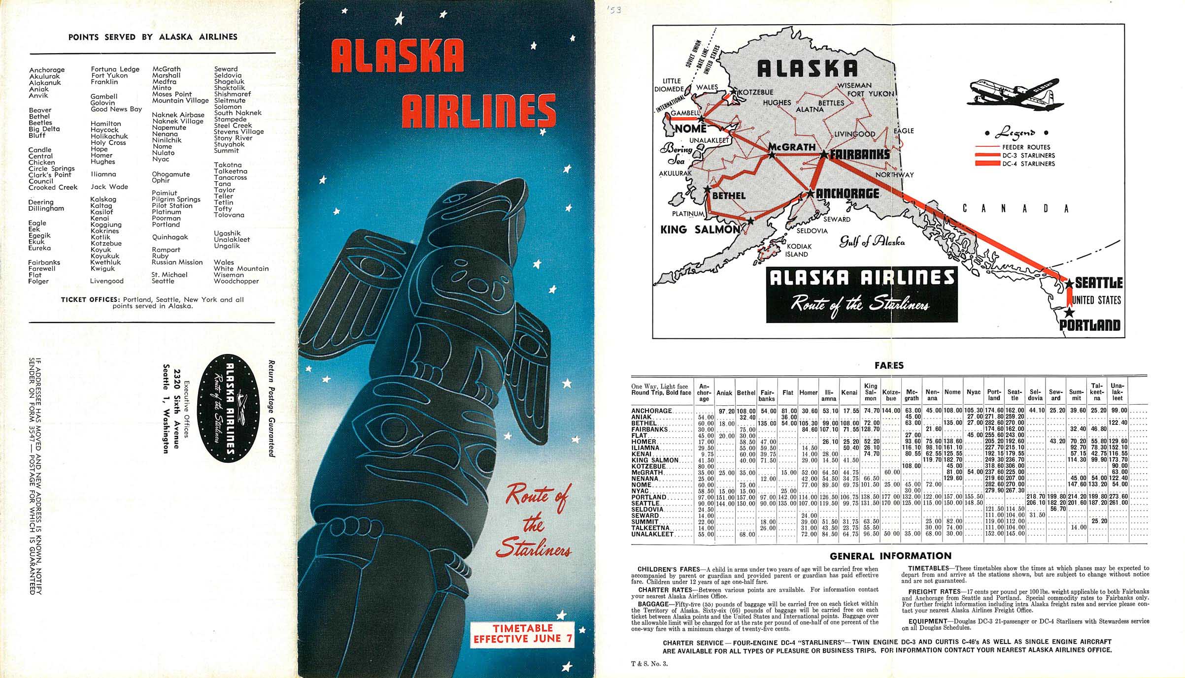
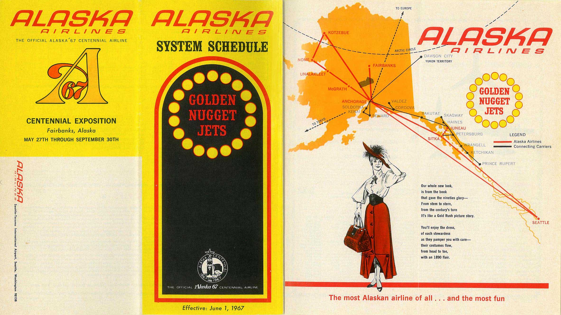
The airport opened in 1951 and took over existing scheduled airline traffic to Fairbanks, which had previously used Ladd Army Airfield.[5] Alaska Airlines used Fairbanks as its main hub in the 1950s, with service to Seattle and Portland as well as intrastate service to Anchorage, Nome and other destinations.[6] By 1967, however, the airline shifted its Alaska hub to Anchorage; its Anchorage-Fairbanks service continues to this day.[7] In the mid-1970s, following the development of the Trans-Alaska Pipeline, Alaska Airlines and Braniff International offered "interchange service" between Fairbanks and Houston via Anchorage, Seattle and Dallas.[8] In 1982, following airline deregulation, Alaska Airlines and American Airlines began a similar interchange service using Boeing 727s.[9]
Pan American World Airways had also served Fairbanks since 1932. The station was originally opened after the acquisition of Pacific International Airways and used for short-haul services to Juneau, Seattle, Ketchikan, Whitehorse and other destinations.[10] Pan Am intended to use Fairbanks as a stop for service to Asia as early as 1931, but initial difficulty in negotiating landing rights with the Soviet Union, followed by the outbreak of World War II, delayed these plans until decades later. Pan Am service to Fairbanks continued through the opening of FAI until 1965, when the Civil Aeronautics Board terminated Pan Am's rights to serve Alaska.[11]
Pan American World Airways eventually used Fairbanks as a stopover for transpacific service from New York and Seattle to Tokyo starting in September 1969.[12][13][14] In 1974, Pan Am agreed to transfer its Fairbanks-Seattle service to Western Airlines, and requested that the CAB allow its New York-Tokyo service to be suspended from April 1975.[15] Other carriers such as Japan Airlines and Korean Air began to use Fairbanks as a technical stop for transpacific cargo flights in the late 1970s.[5]
Development since the 2000s[edit]
On October 11, 2009, the airport completed a new terminal and began demolishing the old terminal which was built in 1948. The new terminal is built around the modern TSA standards. In addition to architectural design and better security, the main terminal now has six jet-bridges (up from the former five).[16] The 2,700m2 of custom-unitized curtain wall was designed and supplied by Overgaard Ltd. Hong Kong. The special design incorporates double low-e triple glazing. The new building's footprint is smaller than the old building.
For the 12-month period ending February 28, 2018, the airport had 119,898 aircraft operations, an average of 328 per day: 58% general aviation, 31% air taxi, 9% scheduled commercial, and 2% military. At that time there were 569 aircraft based at this airport: 91% single-engine, 8% multi-engine, <1% jet and <1% helicopter.[2]
Facilities[edit]
Terminal[edit]
The terminal building, situated on the northwest side of the airport, contains eight gates: two for commuter carriers and six for larger carriers.
Runways[edit]
Fairbanks International Airport covers an area of 3,470 acres (1,404 ha) at an elevation of 439 feet (134 m) above mean sea level. It has four runways:[2][17]
- Runway 2L/20R: 11,800 by 150 feet (3,597 x 46 m), surface: asphalt
- Runway 2R/20L: 4,501 by 75 feet (1,981 x 30 m), surface: asphalt
- Runway 2/20: 2,900 by 75 feet (884 x 23 m), surface: gravel/ski strip
- Runway 2W/20W: 5,400 by 100 feet (1,646 x 30 m), surface: water/winter ski strip
Airlines and destinations[edit]
Passenger[edit]
| Airlines | Destinations | Refs |
|---|---|---|
| 40-Mile Air | Delta, Healy Lake, Tok | [18] |
| Air North | Seasonal Charter: Dawson City | [19] |
| Alaska Airlines | Anchorage, Seattle/Tacoma | [20] |
| Delta Air Lines | Seattle/Tacoma Seasonal: Minneapolis/St. Paul | [21] |
| Everts Air | Anaktuvuk Pass, Arctic Village, Eagle, Fort Yukon, Galena, Huslia, Kaktovik/Barter Island, Kaltag, Nulato, Ruby, Venetie | [22] |
| United Airlines | Seasonal: Chicago–O'Hare, Denver (resumes May 23, 2024)[23] | [24] |
| Warbelow's Air Ventures | Beaver, Central, Circle, Manley Hot Springs, Minto, Rampart, Stevens Village | [25] |
| Wright Air Service | Allakaket, Anaktuvuk Pass, Arctic Village, Bettles, Birch Creek, Chalkyitsik, Deadhorse/Prudhoe Bay, Fort Yukon, Galena, Hughes, Huslia, Kaktovik/Barter Island, Kaltag, Koyukuk, Lake Minchumina, Nulato, Ruby, Tanana, Venetie | [26] |
Cargo[edit]
| Airlines | Destinations |
|---|---|
| Amazon Air | Portland (OR), Spokane[27] |
| DHL Aviation | Los Angeles |
| Empire Airlines | Anchorage |
Statistics[edit]
Graphs are unavailable due to technical issues. There is more info on Phabricator and on MediaWiki.org. |
.jpg)


| Rank | City | Passengers | Carriers |
|---|---|---|---|
| 1 | Seattle/Tacoma, WA | 274,000 | Alaska, Delta |
| 2 | Anchorage, AK | 191,000 | Alaska |
| 3 | Minneapolis/St. Paul, MN | 15,000 | Delta |
| 4 | Chicago, IL | 13,000 | United |
| 5 | Galena, AK | 8,000 | Everts, Wright |
| 6 | Fort Yukon, AK | 5,000 | Everts, Wright |
| 7 | Anaktuvuk Pass, AK | 3,000 | Everts, Wright |
| 8 | Huslia, AK | 2,000 | Everts, Wright |
| 9 | Bettles, AK | 2,000 | Wright |
| 10 | Tanana, AK | 1,000 | Wright |
[edit]
| Rank | Airline | Passengers | Percent of market share |
|---|---|---|---|
| 1 | Alaska Airlines | 638,000 | 60.33% |
| 2 | Horizon Air | 190,000 | 17.94% |
| 3 | Delta Air Lines | 135,000 | 12.80% |
| 4 | Wright Air Service | 48,000 | 4.51% |
| 5 | United Airlines | 27,000 | 2.58% |
| 6 | Other Airlines | 19,000 | 1.83% |
Annual traffic[edit]
Graphs are unavailable due to technical issues. There is more info on Phabricator and on MediaWiki.org. |
Accidents and incidents[edit]
- On December 30, 1951, Transocean Air Lines Flight 501, a Curtiss C-46 Commando, a cargo flight, crashed on approach to FAI due to not following radio procedures and spatial disorientation. All four occupants were killed. The wreckage was found on January 3, 1952.[29]
- On February 16, 1975, a Pacific Alaska Airlines DC-6, a cargo flight, crashed attempting to return to Fairbanks Int'l Airport. Three engines lost power after takeoff from runway 10 and crashed 2 km short of runway 19 attempting to return to the airport possibly due to fuel contamination. All three occupants were killed.[30]
- On February 28, 1994, during takeoff for a ferry flight to Miami, a Lockheed L-1011-1 Tristar of Rich International Airways (registered N303EA) experienced a mechanical power loss on the number 3 and number 1 engines and an internal fire on the number 1 engine. The takeoff was aborted and during the taxi back, the fire on the number 1 engine was extinguished. None of the 3 occupants on board were injured.[31]
- On April 23rd, 2024, approximately six minutes after takeoff, an Alaska Air Fuel DC-4, (registered N3054V), suffered an engine explosion and crashed along the Tanana River 8 miles southwest of Fairbanks. Two occupants were onboard the plane, both were killed.
References[edit]
- ^ a b "2020 CENSUS - CENSUS BLOCK MAP: South Van Horn CDP, AK" (PDF). U.S. Census Bureau. Retrieved 2023-07-01.
- ^ a b c d FAA Airport Form 5010 for FAI PDF. Federal Aviation Administration. effective February 22, 2024.
- ^ a b "Fairbanks, AK: Fairbanks International (FAI)". Bureau of Transportation Statistics (BTS), Research and Innovative Technology Administration (RITA), U.S. Department of Transportation. Retrieved December 12, 2023.
- ^ International Transportation Fact Sheet Archived 2008-07-08 at the Wayback Machine, State of Alaska Governor's Office of International Trade
- ^ a b "History of Fairbanks International Airport". Fairbanks International Airport. Alaska Department of Transportation & Public Facilities. 2011.
- ^ "Alaska Airlines system schedule". Timetable Images. June 7, 1953.
- ^ "Alaska Airlines system schedule". Timetable Images. June 1, 1967.
- ^ "Alaska Airlines System Wide Routes". Departed Flights. February 1, 1975.
- ^ "History of American Airlines". American Airlines. June 2015. Archived from the original on 2012-05-26.
- ^ "Pan Am to stop Alaska flights, closes chapter in aviation history". Ellensburg Daily Record. UPI. September 19, 1978.
- ^ Kiffer, Dave (December 29, 2006). "Pan Am: Once Ketchikan's Link to the Outside World". Stories in the News. Ketchikan, Alaska.
- ^ "Pan Am introduces the first nonstop service from Fairbanks to Tokyo". Fairbanks Daily News-Miner. August 5, 1969.
- ^ "Pan Am route map" (Map). Departed Flights. February 1, 1972.
- ^ "Pan Am World Routes" (Map). Departed Flights. April 29, 1973.
- ^ "Pan Am route sale to Western okayed by CAB". Eugene Register-Guard. Associated Press. February 14, 1975.
- ^ "Archived copy" (PDF). Archived from the original (PDF) on November 21, 2008. Retrieved October 15, 2008.
{{cite web}}: CS1 maint: archived copy as title (link) - ^ "FAI airport data at skyvector.com". skyvector.com. Retrieved September 12, 2022.
- ^ "40-Mile Air Scheduled Destinations". 40-Mile Air. Retrieved 22 November 2022.
- ^ "Flight Schedules". Air North. Retrieved January 11, 2021.
- ^ "Route Map". Retrieved February 11, 2021.
- ^ "Flight Status & Notifications". Delta Air Lines. Retrieved January 11, 2021.
- ^ "Passenger Schedules". Retrieved 22 November 2022.
- ^ "United Airlines Adds New Alaska and Canada Routes". January 18, 2024. Retrieved January 18, 2024.
- ^ "Check flight schedules and notifications". United Airlines. Retrieved January 11, 2021.
- ^ "Scheduled Service". Warbelow's Air Ventures. Retrieved Sep 15, 2022.
- ^ "Timetable". Wright Air Service. Retrieved Sep 15, 2022.
- ^ "StackPath". 15 October 2021.
- ^ "BTS Transtats". Washington, DC: Bureau of Transportation.
- ^ Accident description for N68963 at the Aviation Safety Network. Retrieved on September 12, 2022.
- ^ Accident description for N77DG at the Aviation Safety Network. Retrieved on October 29, 2020.
- ^ "Accident description". Aviation Safety Network. Retrieved February 24, 2021.
External links[edit]
- Fairbanks International Airport (official web site)
- FAI Terminal Area Development Project
- FAA Alaska airport map (GIF)
- FAA Alaska airport diagram (GIF)
- FAA Airport Diagram for Fairbanks International (PDF), effective April 18, 2024
- FAA Terminal Procedures for Fairbanks International, effective April 18, 2024
- Resources for this airport:
- FAA airport information for FAI
- AirNav airport information for PAFA
- ASN accident history for FAI
- FlightAware airport information and live flight tracker
- NOAA/NWS latest weather observations for PAFA
- SkyVector aeronautical chart for FAI
- Check current FAA delays for this airport
| International | |
|---|---|
| National | |