
Schiedam
Schiedam | |
|---|---|
City and municipality | |
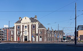
 Old city hall of Schiedam | |
 Flag Coat of arms | |
| Nickname: Brandersstad | |
.svg) Location in South Holland | |
| Coordinates: 51°55′N 4°24′E / 51.917°N 4.400°E | |
| Country | Netherlands |
| Province | South Holland |
| Settled | c. 1230 |
| City rights | 1275 |
| Government | |
| • Body | Municipal council |
| • Mayor | Cor Lamers (CDA) |
| Area | |
| • Total | 19.86 km2 (7.67 sq mi) |
| • Land | 17.82 km2 (6.88 sq mi) |
| • Water | 2.04 km2 (0.79 sq mi) |
| Elevation | −1 m (−3 ft) |
| Population (January 2021)[4] | |
| • Total | 79,279 |
| • Density | 4,449/km2 (11,520/sq mi) |
| Demonym | Schiedammer |
| Time zone | UTC+1 (CET) |
| • Summer (DST) | UTC+2 (CEST) |
| Postcode | 3100–3125 |
| Area code | 010 |
| Website | www |


Schiedam (Dutch pronunciation: [sxiˈdɑm] ⓘ) is a city and municipality in the west of the Netherlands. It is located in the Rotterdam–The Hague metropolitan area, west of Rotterdam, east of Vlaardingen, and south of Delft. In the south the city is connected with the village of Pernis by the Beneluxtunnel.
The city is known for its historical center with canals, and for having the tallest windmills in the world.
Schiedam is also well known for the distilleries and malthouses and production of jenever, such as the internationally renowned Ketel One; in French and English, the word schiedam (usually without a capital s-) refers to the town's jenever. This was the town's main industry during the early Industrial Revolution in the 18th and 19th century, a period to which it owed its former nickname "Zwart Nazareth" ("Black Nazareth").
The city is also known for Saint Lidwina, one of the most famous Dutch saints, whose relics are located in the city’s basilica.
History[edit]
Schiedam was founded around the year 1230. The river Schie was dammed by the Lord of Wassenaer and the Amtlord Dirk Bokel of the Amt Mathenesse, this to protect the existing polderland against the seawater from the North Sea.[citation needed] In 1247, Lady Adelaide (Aleida) of Holland married John I, Count of Hainaut. [citation needed] As dowry she received from him[clarification needed] the eastern part of the dam together with the adjacent polder. The dam attracted many trade activities because goods for and from the hinterland (Delft, and further away Leiden and Haarlem) had to be transhipped. A small town developed swiftly around the dam and its activities. In the year 1275 Schiedam received city rights from Lady Adelaide, this in her capacity as sister of William II, the reigning Count of Holland and King of the Romans. She ordered the building of Te Riviere Castle near the Schie, which is known today as "Castle Mathenesse" (Dutch: "Huis te Riviere" or "Slot Mathenesse"). Remnants of a donjon, which were once part of the castle, are still visible today in the centre of Schiedam and near the city office.[citation needed]
As a young settlement Schiedam soon got competition from surrounding towns and cities: in 1340, Rotterdam and Delft also were allowed to establish a connection between the Schie and the Meuse. From the 15th century onwards the city flourished as a place of pilgrimage due to the devotion afforded to Saint Lidwina, one of the most famous Dutch saints who lived her life in Schiedam. The city subsequently gained significance by fishing for herring. In 1428 a great city fire swept through Schiedam, destroying large parts of the then wooden city.[citation needed]
In 1575 the world's first known commercial distillery started operations in Schiedam.[5] The 18th century was Schiedam's Golden Age, when the gin industry flourished. The standstill in drink imports from France made the boom in Schiedam's distilleries possible.[citation needed] From dozens of distilleries Schiedam jenever was exported throughout the world. The gin industry gave the city its nickname "Black Nazareth". This industry is now largely gone. Five windmills in the town, called De Noord, Walvisch, Drie Koornbloemen, Nieuwe Palmboom and Vrijheid − are the highest traditional-style windmills in the world because they had to stick out above the high warehouses, and many storehouses are relics of this past. In one of the former factories at the Lange Haven the National Jenever Museum operates.[citation needed]
On 10 August 1856, the first major train accident in the Netherlands happened near Schiedam Centrum railway station, causing 3 deaths. On 4 May 1976 the 1976 Schiedam train accident also took place near the station, which caused 24 deaths.[6]
At the end of the 19th and throughout the 20th century, the shipbuilding industry boomed in Schiedam, with large companies like Wilton-Fijenoord and others. In 1941, the ancient municipalities Kethel en Spaland were merged with Schiedam, which made large expansions of the city possible with residential areas in the north. [citation needed] At the end of the 20th century, the shipbuilding industry largely disappeared and today, Schiedam is mainly a commuter-area in the Rotterdam metropolitan area.[citation needed]
Geography[edit]
The city of Schiedam is located in the province of South Holland. It is enclosed between Rotterdam (east), Midden-Delfland (north), Vlaardingen (west) and the river Nieuwe Maas (south).
Schiedam exists of nine districts: Centrum ('Center'), Oost ('East'), Gorzen ('South'), West ('West'), Nieuwland, Groenoord, Kethel, Woudhoek and Spaland/Sveaparken.[7]
Demographics[edit]
55,44% Dutch background, 14,42% Western migration background, 30,15% Non western migration background[citation needed]
Attractions[edit]
Museums[edit]
- Stedelijk Museum Schiedam[8]
- Jenevermuseum (Schiedam)[9]
- Het Borrelmuseum (in 't Spul on Hoogstraat)
- De Walvisch[10]
- Nationaal Coöperatie Museum Schiedam / 't Winkeltje
- Artgallery 't Walvisch
Monuments[edit]
- The old city hall (Oude stadhuis (Schiedam))
- The canals of Schiedam
- The Wheat Exchange (De Korenbeurs)
- Church of Saint John (Grote of Sint-Janskerk)
- The ruins of Te Riviere Castle[11]
- Saint Lidwina basilica[12]
- De Plantage (a park)
- The Porters' Guild House (Zakkendragershuisje (Schiedam))
- Het Proveniershuis (housing elderly people)
- The historical windmills of Schiedam. This includes the tallest windmill in the world which is used as a restaurant.
Events[edit]
- Brandersfeesten[13]
- The National Windmill Days[14] (Nationale Molen- & Gemalen dag)
- Monthly art exhibition at Artipico Art Gallery[15] (maandelijkse Kunstborrel)
Past notable events[edit]
- 1856 Schiedam train accident
- 1976 Schiedam train accident
- 1976 Schiedam riots
- 2012 lip dub World record attempt[16]
Sport[edit]
The most popular sports in Schiedam are soccer and field hockey. The town used to have two professional soccer teams, one named SVV (Schiedamse voetbal vereniging), whereas the other one was named Hermes along the Damlaan where also cricket was played. Both disappeared from the professional level after financial problems. Cricket is also rather popular in Schiedam due to having two cricket teams playing on the highest national level, the topklasse. The Dutch capital Amsterdam for example only has one. Earlier mentioned team Hermes D.V.S. boasts two topklasse titles, where rivals Excelsior '20 holds eleven titles respectively.[17]
Education[edit]
There are about 35 schools in Schiedam. The oldest high school is the Stedelijk Gymnasium Schiedam, dating back to 1346. Other schools include Lyceum Schravenlant, Spieringshoek and Lentiz LIFE.
Notable people[edit]
Public thinking & public service[edit]


- Saint Lidwina (1380–1433) a Dutch mystic, honored as a saint by the Catholic Church.[18]
- Jacobus Taurinus (1576–1618) a preacher and theologian, supporter of the Remonstrants
- Cornelius Haga (1578–1654) ambassador of the Dutch Republic to the Ottoman Empire
- Willem Nieupoort (1607–1678) a politician and ambassador, negotiated the Treaty of Westminster (1654)
- Jan van Riebeeck (1619–1677) colonial administrator, founded Cape Town, South Africa
- James Scott, 1st Duke of Monmouth (1649–1685) illegitimate son of Charles II of England
- Harmen van Bol'es (1689-1764) a Royal master builder in Russia, Town Carpenter in Schiedam
- Engelbertus Lucas Sr. (1747–1797) a Dutch rear-admiral, commanding a squadron of the Batavian Navy
- Engelbertus Lucas Jr. (1785–1870) a Dutch senior naval officer
- Piet Paaltjens (1835–1894) a Protestant clergyman and romantic author
- Christian Osepins (1858–1887) a US Navy sailor, recipient of the Medal of Honor
- Dirk Jan de Geer (1870–1960) a politician, Dutch Prime Minister 1926/1929 and 1939/1940
- Philips Christiaan Visser (1882–1955) a diplomat, geographer, mountaineer and glaciologist
- Jeanne Lampl-de Groot (1895–1987) a Dutch psychiatrist, worked with Sigmund Freud
- Thomas van der Hammen (1924-2010) a Dutch palaeontologist, botanist and geologist
- Wil Velders-Vlasblom (1930-2019) a Dutch politician and woman's rights activist
- Pieter van Vollenhoven (born 1939) husband of Princess Margriet of the Netherlands
- Johannes Bronkhorst (born 1946) an academic and Indologist specialising in early Buddhism
- Elizabeth Witmer (born 1946) member of the Legislative Assembly of Ontario, Canada
- Herman Heinsbroek (born 1951) entrepreneur and former Minister of Economic Affairs
- Pieter Elbers (born 1970) a Dutch airline executive, President and CEO of KLM
The arts[edit]

- Adam Pynacker (1622–1673) Dutch Golden Age painter, mostly of landscapes
- Piet van Stuivenberg (1901–1988) sculptor, painter, lithographer and graphic artist
- Arnold van Mill (1921–1996) a Dutch opera singer who sang bass
- Wim Meuldijk (1922–2007) writer, illustrator and screenwriter; created Pipo de Clown[19]
- Theresia van der Pant (1924–2013) a Dutch sculptor
- Gé Korsten (1927-1999) a South African singer of Dutch descent
- Rien Poortvliet (1932–1995) Dutch painter of the Gnomes book series
- Henk de Vlieger (born 1953) a Dutch percussionist, composer and arranger
- Mike Redman (born 1978) a musician, record producer and film maker [20]
- Joey Roukens (born 1982) a Dutch composer of contemporary classical music
Sport[edit]


- Rinus Gosens (1920–2008) a football player and manager
- Hans Eijkenbroek (born 1940) a retired footballer with 339 club caps and manager
- Pauline van der Wildt (born 1944) a retired Dutch swimmer, team bronze medallist at the 1964 Summer Olympics
- Yvonne Buter (born 1959) a former Dutch field hockey goalkeeper, team bronze medallist at the 1988 Summer Olympics
- John de Wolf (born 1962) a Dutch former professional footballer with over 350 club caps
- Angela Venturini (born 1964) a Dutch former cricketer
- Willem Noorduin (born 1967) a Paralympian athlete and Olympic medallist
- Robin van der Laan (born 1968) a former footballer with 401 club caps and manager
- Robert Maaskant (born 1969) a Dutch former professional footballer and current manager
- Luuk van Troost (born 1969) cricketer, captained the Netherlands national cricket team
- Erik Jazet (born 1971) a former field hockey player, team medallist in three Olympic Games
- Andre van Troost (born 1972) a Dutch former cricketer, a right-arm fast bowler
- Rob Cordemans (born 1974) a Dutch baseball player
- Ali Elkhattabi (born 1977) a retired Dutch-Moroccan footballer with 238 club caps
- Danny Koevermans (born 1978) a Dutch former footballer with 296 club caps, currently a coach
- Gökhan Saki (born 1983) a Dutch-Turkish kickboxer and mixed martial artist
- Jos van Emden (born 1985) a Dutch road bicycle racer and time-trial specialist
- Nick de Bruijn (born 1987) a Dutch racing driver
- Kelly Dulfer (born 1994) a Dutch handball player with the Dutch national team
- Joshua Zirkzee (born 2001) a Dutch football player
International relations[edit]
Twin towns – Sister cities[edit]
Schiedam was twinned with:
 - Vienne, France
 - Esslingen am Neckar, Germany (since 1964)
 - Piotrków Trybunalski, Poland (since 1992)
 - Velenje, Slovenia (since 1970)
 - Neath Port Talbot, Wales (since 1964)[21]
 - Udine, Italy
 - Wandsworth, England (since 1946)
The relations between Schiedam and these cities was stopped in 2008, after Schiedam joined Eurotowns[22]
Gallery[edit]
-
 New townhall and basilica
 -
 Ruin: Huis te Riviere
 -
 Church: de Grote of Sint Janskerk
 -
 Church: Johannes de Doperkerk
 -
 Sculpture (de Zakkendrager)
 -
 Ship in the Korte Haven near the Korenbeurs
 -
 Monumental building: het Proveniershuis
 -
 Street view: Broersvest-Rotterdamsedijk
_op_het_Stadserf_IMG_8171_2016-03-13_14.04.jpg)


See also[edit]
References[edit]
- ^ "Dhr. C.H.J. Lamers" [Mr. C.H.J. Lamers] (in Dutch). Gemeente Schiedam. Retrieved 23 August 2013.
- ^ "Kerncijfers wijken en buurten 2020" [Key figures for neighbourhoods 2020]. StatLine (in Dutch). CBS. 24 July 2020. Retrieved 19 September 2020.
- ^ "Postcodetool for 3112DZ". Actueel Hoogtebestand Nederland (in Dutch). Het Waterschapshuis. Archived from the original on 21 September 2013. Retrieved 23 August 2013.
- ^ "Bevolkingsontwikkeling; regio per maand" [Population growth; regions per month]. CBS Statline (in Dutch). CBS. 1 January 2021. Retrieved 2 January 2022.
- ^ Doxat, John (1972). "Bols". The World of Drinks and Drinking: An International Distillation. New York: Drake Publishers. p. 35. ISBN 9780877492542. Retrieved 11 December 2023.
[...] the oldest gin house in the world - presumably the world's oldest commercial distillers - Bols Boord & Son was founded in 1575, at Schiedam [...].
- ^ "Eerste treinramp met doden ook bij Schiedam". Dagblad van het Noorden (in Dutch). May 1, 2004. Retrieved December 2, 2011.
- ^ "Wijken - Gemeente Schiedam". Retrieved 16 November 2016.
- ^ "Stedelijk Museum Schiedam". Stedelijk Museum Schiedam.
- ^ "Nationaal Jenevermuseum Schiedam". Nationaal Jenevermuseum Schiedam.
- ^ "De Schiedamse Molens". www.schiedamsemolens.nl.
- ^ "Scyedam - Kaleida - Ruïne Huis te Riviere". scyedam.delinea.nl.
- ^ "Archived copy". Archived from the original on 2007-10-06. Retrieved 2006-07-06.
{{cite web}}: CS1 maint: archived copy as title (link) - ^ "Brandersfeesten - Jaarlijks feest in Schiedam Centrum". www.brandersfeesten.nl.
- ^ "Nationale molen- en gemalendag - Alles over molens". www.nationalemolenengemalendag.nl.
- ^ Artipico. "Galerie Artipico Schiedam - DIET WIEGMAN CLEMENS BRIELS - JUDITH WIERSEMA". www.artipico.com.
- ^ Yorick de Vries (30 September 2012). "Schiedam 2012 - DOUBLE LIPDUB WORLD RECORD!!! - OLD BETA VERSION". Archived from the original on 2013-07-27 – via YouTube.
- ^ "Hail Holland, world cricket's unlikely lads". Financial Times. 5 March 2007. Archived from the original on 2022-12-10. Retrieved 16 November 2016.
- ^ Albers, Petrus Henricus (1910). . Catholic Encyclopedia. Vol. 9.
- ^ IMDb Database retrieved 29 February 2020
- ^ IMDb Database retrieved 29 February 2020
- ^ "Neath Port Talbot Twin Towns". Neath Port Talbot County Borough Council. Archived from the original on 2013-08-22. Retrieved 2013-08-22.
- ^ "Information about the international relationships by the municipality (in Dutch)".
External links[edit]
 Media from Commons
 Texts from Wikisource
 Travel information from Wikivoyage
Places adjacent to Schiedam | |
|---|---|

| International | |
|---|---|
| National | |
| Geographic | |