
Prefectures of Japan: Difference between revisions
m →List in alphabetical order: made table sortable |
→Lists of prefectures: Removed list in ISO order since table can be sorted by ISO number |
||
| Line 46: | Line 46: | ||
The Japanese government still translates ''Tokyo-to'' as "Tokyo Metropolis" in almost all cases, and the government is officially called the "Tokyo Metropolitan Government." However, some people still call ''Tokyo-to'' "Tokyo Prefecture" in English. |
The Japanese government still translates ''Tokyo-to'' as "Tokyo Metropolis" in almost all cases, and the government is officially called the "Tokyo Metropolitan Government." However, some people still call ''Tokyo-to'' "Tokyo Prefecture" in English. |
||
== |
== List of prefectures == |
||
===List in ISO Order===<!-- Note to editors: The article [[Japan]] links to this header. If you alter this header, kindly alter the link to it in [[Japan]]. Fg2 June 28, 2006 --> |
|||
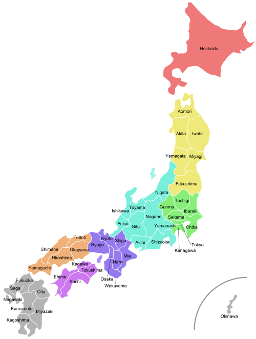
[[Image:Regions and Prefectures of Japan.png|thumb|300px|Map of the prefectures of [[Japan]] in [[ISO 3166-2:JP]] order and the [[regions of Japan]].]] |
[[Image:Regions and Prefectures of Japan.png|thumb|300px|Map of the prefectures of [[Japan]] in [[ISO 3166-2:JP]] order and the [[regions of Japan]].]] |
||
The prefectures are also often grouped into [[Regions of Japan|regions]]. Those regions are not formally specified, they do not have elected officials, nor are they corporate bodies. However, the practice of ordering prefectures based on their geographic location is common. |
The prefectures are also often grouped into [[Regions of Japan|regions]]. Those regions are not formally specified, they do not have elected officials, nor are they corporate bodies. However, the practice of ordering prefectures based on their geographic location is common. |
||
{| |
|||
| style="padding-right:1em; vertical-align:top;" | |
|||
<center>'''[[Hokkaidō]]'''</center> |
|||
---- |
|||
1. [[Hokkaidō]]<br> |
|||
<center>'''[[Tōhoku region|Tōhoku]]'''</center> |
|||
---- |
|||
2. [[Aomori Prefecture|Aomori]]<br> |
|||
3. [[Iwate Prefecture|Iwate]]<br> |
|||
4. [[Miyagi Prefecture|Miyagi]]<br> |
|||
5. [[Akita Prefecture|Akita]]<br> |
|||
6. [[Yamagata Prefecture|Yamagata]]<br> |
|||
7. [[Fukushima Prefecture|Fukushima]]<br> |
|||
<center>'''[[Kantō region|Kantō]]'''</center> |
|||
---- |
|||
8. [[Ibaraki Prefecture|Ibaraki]]<br> |
|||
9. [[Tochigi Prefecture|Tochigi]]<br> |
|||
10. [[Gunma Prefecture|Gunma]]<br> |
|||
11. [[Saitama Prefecture|Saitama]]<br> |
|||
12. [[Chiba Prefecture|Chiba]]<br> |
|||
13. [[Tokyo]]<br> |
|||
14. [[Kanagawa Prefecture|Kanagawa]]<br> |
|||
| style="padding-right:1em; vertical-align:top;" | |
|||
<center>'''[[Chūbu region|Chūbu]]'''</center> |
|||
---- |
|||
15. [[Niigata Prefecture|Niigata]]<br> |
|||
16. [[Toyama Prefecture|Toyama]]<br> |
|||
17. [[Ishikawa Prefecture|Ishikawa]]<br> |
|||
18. [[Fukui Prefecture|Fukui]]<br> |
|||
19. [[Yamanashi Prefecture|Yamanashi]]<br> |
|||
20. [[Nagano Prefecture|Nagano]]<br> |
|||
21. [[Gifu Prefecture|Gifu]]<br> |
|||
22. [[Shizuoka Prefecture|Shizuoka]]<br> |
|||
23. [[Aichi Prefecture|Aichi]]<br> |
|||
<center>'''[[Kansai]]'''</center> |
|||
---- |
|||
24. [[Mie Prefecture|Mie]]<br> |
|||
25. [[Shiga Prefecture|Shiga]]<br> |
|||
26. [[Kyoto Prefecture|Kyoto]]<br> |
|||
27. [[Osaka Prefecture|Osaka]]<br> |
|||
28. [[Hyōgo Prefecture|Hyōgo]]<br> |
|||
29. [[Nara Prefecture|Nara]]<br> |
|||
30. [[Wakayama Prefecture|Wakayama]]<br> |
|||
| style="padding-right:1em; vertical-align:top;" | |
|||
<center>'''[[Chūgoku region|Chūgoku]]'''</center> |
|||
---- |
|||
31. [[Tottori Prefecture|Tottori]]<br> |
|||
32. [[Shimane Prefecture|Shimane]]<br> |
|||
33. [[Okayama Prefecture|Okayama]]<br> |
|||
34. [[Hiroshima Prefecture|Hiroshima]]<br> |
|||
35. [[Yamaguchi Prefecture|Yamaguchi]]<br> |
|||
<center>'''[[Shikoku]]'''</center> |
|||
---- |
|||
36. [[Tokushima Prefecture|Tokushima]]<br> |
|||
37. [[Kagawa Prefecture|Kagawa]]<br> |
|||
38. [[Ehime Prefecture|Ehime]]<br> |
|||
39. [[Kochi Prefecture|Kochi]]<br> |
|||
<center>'''[[Kyūshū]] & [[Okinawa]]'''</center> |
|||
---- |
|||
40. [[Fukuoka Prefecture|Fukuoka]]<br> |
|||
41. [[Saga Prefecture|Saga]]<br> |
|||
42. [[Nagasaki Prefecture|Nagasaki]]<br> |
|||
43. [[Kumamoto Prefecture|Kumamoto]]<br> |
|||
44. [[Ōita Prefecture|Ōita]]<br> |
|||
45. [[Miyazaki Prefecture|Miyazaki]]<br> |
|||
46. [[Kagoshima Prefecture|Kagoshima]]<br> |
|||
47. [[Okinawa Prefecture|Okinawa]] <br> |
|||
|} |
|||
[[Karafuto Prefecture|Karafuto]], a portion of the island of [[Sakhalin]] north of Hokkaidō (not shown on the map), was part of Japan from [[1907]] until [[World War II]]. The entire island is now governed by [[Russia]], but some Japanese people claim Karafuto is still part of Japan. |
[[Karafuto Prefecture|Karafuto]], a portion of the island of [[Sakhalin]] north of Hokkaidō (not shown on the map), was part of Japan from [[1907]] until [[World War II]]. The entire island is now governed by [[Russia]], but some Japanese people claim Karafuto is still part of Japan. |
||
<br clear="all"> |
|||
===List in alphabetical order=== |
|||
{| class="wikitable sortable" |
{| class="wikitable sortable" |
||
|- |
|- |
||
Revision as of 12:00, 24 September 2007
| Administrative divisions of Japan |
|---|
| Prefectural |
| Prefectures |
| Sub-prefectural |
| Municipal |
| Sub-municipal |
The prefectures of Japan are the country's 47 sub-national jurisdictions: one "metropolis" (都 to), Tokyo; one "circuit" (道 dō), Hokkaidō; two urban prefectures (府 fu), Osaka and Kyoto; and 43 other prefectures (県 ken). In Japanese, they are commonly referred to as todōfuken (都道府県). Prefectures are governmental bodies larger than cities, towns, and villages. Each prefecture is led by a directly elected governor and a single-chamber parliament.
The current system was established by the Meiji government in July 1871 with the abolition of the han system and establishment of the prefecture system (廃藩置県 haihan-chiken). Although there were initially over 300 prefectures, many of them being former han territories, this number was reduced to 72 in the latter part of 1871, and 47 in 1888. The Local Autonomy Law of 1947 gave more political power to prefectures, and installed prefectural governors and parliaments.
In 2003, then- Prime Minister Junichiro Koizumi proposed that the government consolidate the current prefectures into about 10 regional states. The plan called for each region to have greater autonomy than existing prefectures. This process will reduce the number of sub-prefecture administrative regions, and is expected to cut administrative costs.[1] The Japanese government is also considering a plan by which several groups of prefectures would merge, creating a sub-national administrative division system consisting of between nine and thirteen states, and giving these states more local autonomy than the current prefectures enjoy.[2] As of April 2007, no reorganization has taken place.
Under the current Local Autonomy Law, each prefecture is further subdivided into cities (市 shi) and districts (郡 gun). Each district is further subdivided into towns (町 chō or machi) and villages (村 son or mura). Hokkaidō has 14 subprefectures and those act as branch offices (支庁 shichō) of the prefecture. Some other prefectures also have branch offices, which carry out prefectural administrative functions outside the capital.
Types of prefectures

To, dō, fu, and ken differ in name only for historical reasons. Since 1947, there is no administrative difference between the four types. Usually, prefectures are called by their name only, without the suffix, except for Hokkaidō. However, the suffix is used when it is necessary to distinguish between the prefecture and a city of the same name. For example, Hiroshima-ken is the Japanese name of the prefecture, and Hiroshima-shi is its largest city.
Fu (Osaka/Kyoto) and Ken
During the Edo period, the bakufu established bugyō-ruled zones (奉行支配地) around the nine largest cities in Japan, and 302 township-ruled zones (郡代支配地) elsewhere. When the Meiji government began to create the prefectural system in 1868, the first year of Meiji era, while the nine bugyō-ruled zones became fu, the township-ruled zones and the rest of the bugyo-ruled zones became ken: later, in 1871 the government designated Tokyo, Osaka, and Kyoto as fu, and relegated the other fu to the status of ken. During World War II, in 1943, Tokyo became a to, a new type of pseudo-prefecture (see below).
Before World War II, different laws applied to fu and ken, but this distinction was abolished after the war, and the two types of prefecture are now functionally the same. As a result, the English language does not usually distinguish between fu and ken, calling both simply "prefectures."
Hokkaidō
The term dō (circuit) was originally used to refer to regions of Japan, such as Tōkaidō and Saikaidō, consisting of several provinces. It uses the Kanji for "road" and is considered to have been settled by Emperor Temmu.
Hokkaidō, the only remaining dō today, was not one of the original seven dō (it was known as Ezo in the pre-modern era). Its current name is believed to originate from Matsuura Takeshiro, an early Japanese explorer of the island. Since Hokkaidō did not fit into the existing dō classifications, a new dō was created to cover it.
The Meiji government originally classified Hokkaidō as a "Settlement Envoyship" (開拓使 kaitakushi), and later divided the island into three prefectures (Sapporo, Hakodate, and Nemuro). These were consolidated into a single Hokkaidō prefecture in 1886. The -ken suffix was never added to its name, so the -dō suffix became understood to mean "prefecture."
When Hokkaidō was incorporated, transportation on the island was still very underdeveloped, so the prefecture was split into several "sub-prefectures" (支庁 shichō) that could fulfill administrative duties of the prefectural government and keep tight control over the developing island. These sub-prefectures still exist today, although they have much less power than they possessed before and during World War II: they now exist primarily to handle paperwork and other bureaucratic functions.
"Hokkaidō Prefecture" is, technically speaking, a redundant term, although it is occasionally used to differentiate the government from the island itself. The government of the prefecture calls itself the "Hokkaidō Government" rather than the "Hokkaidō Prefectural Government."
The largest city and prefectural capital of Hokkaidō is Sapporo, the fifth largest city in Japan. Other major cities include Hakodate.
Tokyo-to
The only to in Japan is Tokyo. Following the abolition of the han system, Tokyo-fu (an urban prefecture like Kyoto and Osaka) encompassed a number of cities, the largest of which was Tokyo City. Tokyo City was divided into 15 wards.
In 1943, Tokyo City was abolished, Tokyo-fu became Tokyo-to, and Tokyo's wards became the special wards, local authorities falling directly under the prefecture in hierarchy, each with their own elected assemblies (kugikai) and mayors (kucho). A number of suburban villages and towns of Tokyo City were changed to wards, bringing the total number of special wards to 35.
The reason for this reorganization was to consolidate the administration of the area around the capital by eliminating the extra level of authority in Tokyo. The central government wanted to have a greater degree of control over Tokyo due to Japan's deteriorating position in World War II and the possibility of emergency in the metropolis.
After the war, Japan was forced to decentralize Tokyo again, following the general terms of democratization outlined in the Potsdam Declaration. Many of Tokyo's special governmental characteristics disappeared during this time, and the wards took on an increasingly municipal status in the decades following the surrender. Administratively, today's special wards are almost indistinguishable from other municipalities.
The postwar reforms also changed the map of Tokyo significantly. In 1947, the 35 wards were reorganized into the 23 special wards, because many had died in the bombardments during the war, many survivors had left the city, and many men who had been drafted had not returned.
There are some differences in terminology between Tokyo and other prefectures: police and fire departments are called chō (庁) instead of honbu (本部), for instance. However, the only functional difference between Tokyo-to and other prefectures is that Tokyo administers wards as well as cities. Today, since the special wards have almost the same degree of independence as Japanese cities, the difference in administration between Tokyo and other prefectures is fairly minor (see 23 special wards for details).
The Japanese government still translates Tokyo-to as "Tokyo Metropolis" in almost all cases, and the government is officially called the "Tokyo Metropolitan Government." However, some people still call Tokyo-to "Tokyo Prefecture" in English.
List of prefectures

The prefectures are also often grouped into regions. Those regions are not formally specified, they do not have elected officials, nor are they corporate bodies. However, the practice of ordering prefectures based on their geographic location is common.
Karafuto, a portion of the island of Sakhalin north of Hokkaidō (not shown on the map), was part of Japan from 1907 until World War II. The entire island is now governed by Russia, but some Japanese people claim Karafuto is still part of Japan.

Map
References
- ^ http://siteresources.worldbank.org/WBI/Resources/wbi37175.pdf Mabuchi, Masaru, "Municipal Amalgamation in Japan," World Bank, 2001.
- ^ http://www.nira.go.jp/publ/seiken/ev18n10/ev18n10-s.html "Doshusei Regional System," National Association for Research Advancement
See also
- Government of Japan
- List of Japanese prefectures by population
- List of Japanese prefectures ranked by area
- List of regions in Japan
- ISO 3166-2 codes for Japan
- Kokura Prefecture - created from three prefectures in December 1871 and absorbed into Fukuoka prefecture in 1876
