
Las Palmas: Difference between revisions
Undid revision 319331912 |
|||
| Line 327: | Line 327: | ||
Las Palmas is served by [[Gran Canaria Airport]], often called ''Las Palmas Airport'' {{airport codes|LPA|GCLP}}. In 2008, it handled 10,212,106 passengers<ref>[http://www.aena.es/csee/ccurl/Total_2008.xls AENA passenger and aircraft movements for 2008]</ref>, making it the busiest airport in the [[Canary Islands]] and the [[List of airports in Spain|fifth busiest]] in Spain. Airport serve 33,695,248 kg of cargo, in this regard it's fourth busiest in Spain. It is also the only airport on the islands with two runways, allowing it to have up to 53 landings and take-offs per hour. The lengthy runways make the airport an alternative landing site for the [[NASA]] [[Space Shuttle]]<ref>[http://www.globalsecurity.org/space/facility/sts-els.htm Space Shuttle Emergency Landing Sites]</ref>. Also, at this airport exist based on [[Binter Canarias]] and [[Navegacion y Servicios Aéreos Canarios (NAYSA)]], a regional carriers operating inter-island services within the Canary Islands. The Airport is located to the east of Gran Canaria on the Bay of Gando (Bahía de Gando), about 18 km (11 mi) from the city. |
Las Palmas is served by [[Gran Canaria Airport]], often called ''Las Palmas Airport'' {{airport codes|LPA|GCLP}}. In 2008, it handled 10,212,106 passengers<ref>[http://www.aena.es/csee/ccurl/Total_2008.xls AENA passenger and aircraft movements for 2008]</ref>, making it the busiest airport in the [[Canary Islands]] and the [[List of airports in Spain|fifth busiest]] in Spain. Airport serve 33,695,248 kg of cargo, in this regard it's fourth busiest in Spain. It is also the only airport on the islands with two runways, allowing it to have up to 53 landings and take-offs per hour. The lengthy runways make the airport an alternative landing site for the [[NASA]] [[Space Shuttle]]<ref>[http://www.globalsecurity.org/space/facility/sts-els.htm Space Shuttle Emergency Landing Sites]</ref>. Also, at this airport exist based on [[Binter Canarias]] and [[Navegacion y Servicios Aéreos Canarios (NAYSA)]], a regional carriers operating inter-island services within the Canary Islands. The Airport is located to the east of Gran Canaria on the Bay of Gando (Bahía de Gando), about 18 km (11 mi) from the city. |
||
There is an airbase of the [[Spanish Air Force]] to the east of the runways. Beyond several hangars opposite to the passenger terminal, the |
There is an airbase of the [[Spanish Air Force]] to the east of the runways. Beyond several hangars opposite to the passenger terminal, the [[Gando Air Base]] (''Base Aérea de Gando'') contains ten shelters situated on the southern end of the eastern runway. They harbor [[F/A-18 Hornet]]s of the 462 and 802 fighter squadron, which defends the Spanish airspace around the Canary Islands. |
||
=== Seaport === |
=== Seaport === |
||
Revision as of 18:21, 13 October 2009
Template:Infobox City Spain Las Palmas de Gran Canaria also known as just Las Palmas is the capital (jointly with Santa Cruz) and the most populous city in the Autonomous Community of the Canary Islands and the ninth largest city in Spain, with a population of 381,123 in 2008. Nearly half (45,9%) of the people of the island and nearly 1/5 (18.35%) of all inhabitants of the Canary Islands lives in this city. It is also the fifth most populous urban area in Spain with a population of around 700,000[1] and (depending on sources) ninth or tenth most populous metropolitan area in Spain with a population of 625,892[2], 640,000[3] or 741,826[4]. Las Palmas is the largest city of the European Union outside Europe. Located in the northeast of the Spanish island of Gran Canaria, about 150 kilometers (~93 miles) off the northwestern coast of Africa[5] within the Atlantic Ocean.
Las Palmas enjoy a Subtropical climate, season with the summer temperatures lasts throughout the year. According to a study carried out by Thomas Whitmore, director of research on climatology at Syracuse University in United States, the Las Palmas enjoys "the best climate in the world".[6]
The city is home to the Canarian Ministry of Presidency (shared in a 4-year term with Santa Cruz), one half of the ministries and boards of the Canarian Government, (the other half being located in Tenerife), Gran Canaria Provincial Courts and two courts of the Superior Court of Justice of the Canary Islands.
History
The city was founded on June 24, 1478, with the name "Real de Las Palmas" by Juan Rejón, head of the invading Castilian army, before engaging in war with the local Guanches (aboriginal people of the Canary Islands). In 1492, Christopher Columbus anchored in the Port of Las Palmas (and spent some time on the island) on his first trip to the Americas. He also stopped on the way back to Spain. Today, a museum is named after him - Casa Colón - in the Vegueta area of the city.

Las Palmas de Gran Canaria is today a cosmopolitan city. It has five beaches (Las Canteras, Las Alcaravaneras, San Cristobal, El Confital and La Laja) and a big seaport (Puerto de la Luz) that was very important during the 70s and early 90s (which benefited greatly from the closure of the Suez Canal during the Arab-Israeli conflict). Due to its situation as nexus of two continents and its importance as a touristic spot, many foreign workers have migrated and settled in the city.
In 1927 was designated the second capital of the Canary Islands so far the only capital of the Canaries was the city of Santa Cruz de Tenerife.[7][8]
The main City Festival (Fiestas de San Juan) is in June, celebrating the foundation of the City.
The Carnival of Las Palmas de Gran Canaria[2] is also widely known not only in Spain but worldwide, one of the main attractions for tourists.
Las Palmas de Gran Canaria is a sister city of San Antonio, Texas in the United States, which was founded in 1718 by about 25 Canary Islanders.
This section needs expansion. You can help by adding to it. (June 2009) |
Administrative divisions

Las Palmas is divided administratively into five districts, which in turn are subdivided into districts, not necessarily consistent with the traditional neighborhoods.
| No | District | Population[9] |
|---|---|---|
| 1 | Vegueta, Cono Sur y Tafira | 73,243 |
| 2 | Centro | 88,546 |
| 3 | Puerto-Canteras | 71,412 |
| 4 | Ciudad Alta | 101,684 |
| 5 | Tamaraceite-San Lorenzo | 39,191 |
Climate
Las Palmas has a Subtropical climate, with warm dry summers and moderately warm winters. Its average annual temperature is 20°C (68 °F): 23°C (75 °F) during the day and 17°C (63 °F) at night. In the coldest month - January, the typically temperature ranges from 18-21°C (64-70°F) during the day, 14-15°C (57-59°F) at night, the average sea temperature is 18-19°C (64-66°F). In the warmest months - August and September, the typically temperature ranges from 25-29°C (77-84°F) during the day, above 20°C (68°F) at night, the average sea temperature is 23°C (73°F). Average number of days per year above 32°C (90°F) is only 3-4 (average 1 in July, 1 in August and 1 in September). Average morning relative humidity: 74%, evening relative humidity: 60%[10]. Sunshine hours is till 2,776 per year, from 186 in December and January (6 hours of sunshine every day) to 310 in July (10 hours of sunshine every day)[11]. Average precipitation days per year is only 33, precipitation per year is only 13.3 cm (inches: 5.2)[12].
According to a study carried out by Thomas Whitmore, director of research on climatology at Syracuse University (USA), the city of Las Palmas enjoys "the best climate in the world"[13][14][15].
| Climate data for Las Palmas | |||||||||||||
|---|---|---|---|---|---|---|---|---|---|---|---|---|---|
| Month | Jan | Feb | Mar | Apr | May | Jun | Jul | Aug | Sep | Oct | Nov | Dec | Year |
| Source: World Meteorological Organization (UN)[16]. | |||||||||||||
Demographics
.PNG)
Ethnically, the population is mostly a mix of Spanish, Portuguese, Germans, British, and South Americans, especially Cubans and Venezuelans as well as Northern and Sub-Sahara Africans. There are also important historical minorities such as Indians (Sindhi), Koreans (see Koreans in Spain#Las Palmas) and lately Russians[citation needed]. Nearly 1/5 (18.35%) of all inhabitants of the Canary Islands lives in Las Palmas (data of 2008).
| Year | Population[citation needed] | Density |
|---|---|---|
| 1991 | 354,887 | 3,529.46/km² |
| 1996 | 355,563 | 3,536.18/km² |
| 2001 | 354,860 | 3,529.19/km² |
| 2002 | 370,649 | 3,686.22/km² |
| 2003 | 377,760 | 3,756.94/km² |
| 2004 | 376,953 | 3,748.92/km² |
| 2007 | 377,203 | 3,751.40/km² |
| 2008 | 381,123 | 3,790.38/km² |
Culture
This section may require copy editing for grammar, style, cohesion, tone, or spelling. (June 2009) |
Las Palmas offers a relatively wide cultural variety of theater, cinema, opera, concerts, visual arts and dance performances are common on billboards in the city, highlighting the Canary Islands Music Festival, the Theater and Dance and the International Film Festival.
Museums, theaters and exhibition halls
- The Museo Canario is in the historic district of Vegueta. Founded in 1879. This is a scientific-cultural range of international partner to the Council for Scientific Research (CSIC). It has a valuable collection of archaeological objects canaries, which are exhibited in 16 rooms. It is also equipped with a library of over 60,000 volumes, many of them about canaries. His archive spans from 1785 until today.
- The Casa Museo de Colón is in the Plaza de San Antonio Abad, in the back of the cathedral. His presentation focuses on the history of the Canary Islands and its relationship with America. It has 13 permanent exhibition halls, a library and study center dedicated and diverse spaces for temporary activities. The complex consists of several houses, one of which was the residence of former Governor (now better known as home of Columbus), accessed by Christopher Columbus during his first trip to America in [[1492] ]. It is organized into five subject areas: America before the Discovery, Columbus and his journeys, Canary enclave strategic base for experimenting with the New World, The History and genesis of the city of Palmas, and painting of the sixteenth century to start of XX.
- The Casa Museo Pérez Galdós is located in another neighborhood of the city, the Triana. It is the birthplace of Benito Pérez Galdós. Here is the best documentary on the Gran novelist with an extensive collection of documents, books, furniture and personal belongings of the writer.
- The Museo Néstor is in the neighborhood of Garden City. Dedicated to the modernist painter Néstor Martín Fernández de la Torre, was opened in 1956 in the architectural ensemble of the Pueblo Canario, which he conceived and built by his brother Miguel Martín Fernández de la Torre . It has 10 exhibition halls, as well as a documentation center and pedagogy.
- The Elder Museum of Science and Technology is an innovative, interactive, engaged in scientific and technological culture. Elder located in the building, which dates from the end of nineteenth century has 4500 m² of exhibition halls, workshops, interactive modules, large-format film and greenhouse ecosystem.
- The Maritime Museum, located in the former station Jet Foil has around 1,000 m². Soon, when they finish the expansion, will have a giant pool to simulate interactive bay, where a large ship can be handled by visitors.
- The Atlantic Center of Modern Art (CAAM), opened in 1989 is one of the most important references for the cultural and artistic life of the Canary Islands. Is responsible for disseminating the art made in the islands with the rest of the world, especially Africa, America and Europe. Has permanent and temporary exhibitions that range from the historical avant-garde to the latest trends. Located on Calle Los Balcones de Vegueta preserves the original facade of the eighteenth century.

- The Teatro Pérez Galdós was designed by the architect Jareño and Francisco Alarcón in 1867. His current appearance, with some modifications, is due to the intervention of Fernando Navarro and Miguel Martín Fernández de la Torre after the fire that destroyed it almost entirely in 1928. This latest collaboration with his brother, the painter Néstor de la Torre, who was commissioned to decorate the stalls, lounges and the stage. It was originally called the Theater of Tirso de Molina, until, in 1901, coinciding with the premiere of "Electra", adopted the name of the writer canary Benito Pérez Galdós. Following works of renovation, the theater reopened in April 2007.
- The Cuyás Theater, on the stage of the former Cine Cuyás is a work of rationalist Canarian architect Miguel Martín Fernández de la Torre. Its main hall has a capacity for 940 people, divided between the stalls and two amphitheaters. It also has a large patio that allows the organization of outdoor events. It is currently constructing an alternative test room with capacity for one hundred seats.
- The Sala Insular de Teatro is a unique scenic area which lies in the main hall of an old church. In 2007, after some refurbishment works, the Board reopened its doors to the public, welcoming small local assemblies.
- The Guiniguada Theater, which is currently closed while waiting for reforms, has for years been the scene of the representation of numerous theatrical production canaria.
Auditorium and Convention Center

- The Auditorio Alfredo Kraus is located on the shores of the Atlantic, near the Playa de Las Canteras, one of the most privileged areas of the city. It has 13,200 m², which has 11 rooms which accommodate from large conventions and concerts to conferences.
- The Palais des congrès de Gran Canaria is in the premises of the Institución Ferial de Canarias with a capacity for 800 people on 16,000 m².
- The Center for Initiatives of the Caja de Ahorros de Canarias (CICC) has made one of the buildings in the middle of the nineteenth century in the neighborhood of Triana by the architect Manuel Ponce de Leon. It is a small conference center with the latest technology and up to 500 guests.
Libraries
The city has a wide network of libraries spread over different districts. Along with the 11 municipal libraries need to review these three centers:
- The Library Island, which has capacity for 500 users in its three floors, besides a hall and more than 100 computer connections with 20 Internet access points.
- La Biblioteca Simón Benitez Padilla, center specializing in geology, biology and ecology that contains valuable bibliographical former president of the Museum Canario Simón Benitez Padilla, notable advocate of the study of the Canarian culture.
- The Archives Joaquín Blanco, which contains 160 years of history of the city, as the burning of the Houses Consistoriales in 1845 destroyed the previous documentary.
A library is situated in the first floor of Woermann Tower.
Other cultural events
- Dance Center
- Festival of Theater and Dance
- Festival Internacional de Cine de Las Palmas de Gran Canaria
- Canary Islands Music Festival
- Jazz Festival
- Carnival of Las Palmas de Gran Canaria
- Founding Celebrations
- WOMAD Las Palmas de Gran Canaria (World of Music Arts and Dance)
- Opera Festival of Las Palmas de Gran Canaria
- Fantastic and Terror Film Festival of Las Palmas de Gran Canaria
Nightlife

The historic district of Vegueta has regained great popularity in recent years, the meeting place of choice for many young people on weekends fill its bars and disco s. In the port area are also numerous bars and nightclubs, particularly in the vicinity of Santa Catalina.
During the Carnival of Las Palmas de Gran Canaria, usually between January and February, you can enjoy many activities such as popular Mogollon (dances) and galas of Franco and the drag queen. Special mention deserves the Festival WOMAD (World Of Music, Art & Dance), usually in November each year scenario is the capital of Gran Canaria. In 2008 has held its fourteenth edition.
Tourism
Beaches
This section may require copy editing for grammar, style, cohesion, tone, or spelling. (June 2009) |


The city has four main beaches, the most important is Las Canteras, Las Alcaravaneras, la Laja and Confital.
- Las Canteras beach (Playa de Las Canteras) has certificate ISO 14001, Spain that they only have the beaches of La Concha in San Sebastián and La Victoria in Cádiz, the introduction of a system for the management of the Environment. Frequently throughout the year, is the beach preferred by most city dwellers and foreign visitors, who can enjoy it at any time of year thanks to the mild climate. Length: 3,100 m. Las Canteras lies on the west side of the Isthmus of Guanarteme, old language of sand dunes and mountains linking the peninsula of La Isleta, located to the northeast, with the rest of the island of Gran Canaria. The beach is the largest of the existing city. It is oriented to the northwest in what is known as Confital bow or bay, and stretches from the foothills of La Isleta until shortly before the mouth of the ravine Tamaraceite, for just over three miles of extensive fine and golden sand. In much of this length, the beach is sheltered from the currents of the Atlantic by a natural barrier, and coral sandstone, which is popularly known by the name of "the bar" and can be reached by swimming from shore. On the inner side of the coast, runs the Paseo de Las Canteras, pedestrian street that runs parallel along the beach from near the Auditorio Alfredo Kraus to the area known as "Puntilla" and hence, in line, until reaching near the beach Confital, place some years ago was only frequented by surfers, which creates what many consider as the best wave right in Europe. La Playa de Las Canteras covers three areas that correspond to the arches and inflections that it conducts on the coast. Each presents certain morphological characteristics[17].
- Las Alcaravaneras beach (Playa de Las Alcaravaneras) stretches rising side of the Isthmus of Guanarteme, old language of sand dunes and mountains linking the peninsula of La Isleta, located to the northeast, with the rest of the island of Gran Canaria. It extends from the Real Club Náutico de Gran Canaria until his meeting with the new marina breakwater of the city for just over half a mile of fine golden sand[18]. The whole beach is covered by the promenade, which starts in Las Alcaravaneras, communicates with the Playa de San Cristobal and ending in Playa de La Laja, ten miles south. This ride is one of the recreational areas of the city and is popular with people who take the opportunity to walk, run, play sports or cycling. The tranquility of the bay and yacht clubs proximadad of existing beach makes a great place to practice sports such as sailing and canoeing. Furthermore, the beach there are facilities for the practice of other sports like beach volleyball, beach soccer or futvóley (organized tournaments in the summer) and court sports such as basketball, indoor soccer and volleyball.
- La Laja beach (Playa de la Laja) with fine sand and gray, there is approximately 1200 m long and 40 m average width. Its moderate waves and currents is no longer dangerous, thanks to the construction of a dam in the south of it carried out around the 90s, too, in the same decade the Ministry of Environment conducted a performance on the beach, to bring sand from the seabed near and in recent years has built a boardwalk that has brought a significant improvement in access on foot. Due to the intensity of their streams and receiving waves, has been hailed as one of the favorite beaches among surfers. It should also be noted that between April and October, every weekend is taken as a starting point to its southern end the race week, from where boats depart lateen.
- Confital beach (Playa del Confital) is located southwest of the peninsula of La Isleta, and is a natural extension of the beach of Las Canteras. The area normally used for swimming covers about two kilometers, but the coastal strip is much greater. It consists of panels of rock with a layer of gravel at the end of them. Until some years ago, on the beach stood a small shanty town, but recently was eradicated and the land of the Confital went back to being publicly giving way to a conservation and maintenance works quite controversial because of doubts, of some environmental movements and the residents of the city, on the legality of the proceedings. The waves arriving at the beach are highly valued by amateur and professional surfers, some consider the Confital right as one of the best waves in Europe[19]. Here, the ocean currents form a tube that is used by more experienced for its speed and strong contrasts. Occur annually in this beach qualifying events for the professional world surfing championship[20].
Parks and Squares
- Avenida Marítima
- Avenida Mésa y López
- El Confital
- Fuente Luminosa
- Parque de la Mayordomía
- Parque de Santa Catalina
- Parque Doramas
- Parque Juan Pablo II
- Parque San Telmo
- Plaza de Canarias
- Plaza de España
- Plaza de La Feria
- Plaza de Las Ranas
- Plaza Santa Ana
- Triana
Other


- Castillo de la Luz
- Centro de Teatro Insular
- CICCA
- El WOMAD
- Fiestas de San Juan
- Gabinete Literario
- Gala Drag Queen
- International Film Festival
- International Theater and Dance Festival
- Museo CAAM Centro Atlántico de Arte Moderno
- Museo Canario
- Museo Casa Colón
- Museo Elder de la Ciencia y la Tecnologia
- Museo Nestor
- Paseo Playa de Las Canteras
- Teatro Pérez Gáldos
- Teatro Cuyas
- Triana
Neighbourhood


- Bandama Caldera (Bandama Natural Monument) in Santa Brígida, Las Palmas is part of the Tafira Protected Landscape. It's considered a point of geological interest, because of the Caldera de Bandama. This volcanic caldera reaches 569 m (1,867 ft) above sea level at the highest point on its rim, Pico de Bandama, and is about 1,000 m (3,300 ft) wide and 200 m (700 ft) deep. The steep walk to the bottom of the caldera takes about half an hour. Volcanic ash of different hues is in great abundance, and there are some interesting botanic species of Canary Islands origin. There are facilities for food and refreshments as well.
- Archaeological sites in Santa Brígida. In the valley of La Angostura and Las Meleguinas can find numerous traces of Aboriginal canaries that have prompted the declaration of the area as a Cultural, as groups of caves carved into rock, silos or sidewalks. In the archaeological site of El Tope, discovered on 16 July 1988, where you can see remnants that suggest the existence of an aboriginal burial mound, as well as ceramics, pottery and curious pintaderas[21][22]. En la pared norte de la Caldera de Bandama se encuentra la Cueva de los Canarios, utilizada por los aborígenes como granero. It has been discovered Libyan-Berber inscriptions and some vessels (which are now in the Museo Canario)[21][22]. Also in the same area in the wall of the volcano in the stew is the Cueva de Los Frailes was discovered in 1933 a set of 37 caves[22].
- Church of San Juan Bautista (commonly known as Catedral de Arucas) built entirely in Arucas stone by local master masons, and it dates from 1909 (Initial Configuration from the XVII century). Apart from the wealth of the carved stone columns and column heads, there are also some beautiful stained glass windows, the works of Canary Island painter Cristobal Hernandez de Quintana, and an extraordinary carving of the Reclining Christ, by Manuel Ramos[23].
- Jardín de la Marquesa de Arucas - Botanical Garden in Arucas.
- Iglesia de San Juan Bautista de Telde is the true spiritual centre of Telde. Located in the square of the same name and founded in 1483, the old church was erected by the Garcia del Castillo family at the time of the town's foundation. It still has the original gateway, an example of Sevillian-Portuguese Gothic architecture. The towers, however, are an example of early 20th neo-Gothic construction. The real marvels are inside the building: the statue of Christ on the main altar, made from corn dough by the Tarasco Mexican Indians, brought here before 1550, the Flemish Gothic main altar, which dates back to before 1516, and the triptych of the Virgin Mary, brought from Flanders, also in the 16th century, depicting five religious scenes [24].
- Archaeological sites in Telde. Telde has 101 archaeological sites and 709 listed assets of ethnographic interest. In regard to the aboriginal time deposits, each year it expands its number or discover new aspects of old fields, but most are in disrepair and many are disappearing. Some of the most prominent are the coastal town of Tufia in good condition and extensively excavated by archaeologists, four doors located on top of a mountain overlooking the plain teldense and consists of a large cave with four doors and its name suggests, plus a ALMOGAREN (religious vessel) at the top and a village of caves with collective barn in the back, the caves of Tara and Cendro remains of the ancient center of population, the town of Draguillo on the border with Ingenio, Las Cuevas Chalasia which consist of a labyrinthine series of artificial caves linked by tunnels and the impressive Necropolis of Jinámar which includes more than 500 tombs of various types belonging to the old canary.
- Basílica de San Juan Bautista in Telde
- Basílica de Nuestra Señora del Pino in Teror from 1760.
Transportation
Roads and highways

Las Palmas, being the centre of the Las Palmas metropolitan area, is the logical hub for the island's motorway network. The city is linked with three superhighways including the GC-1 to the south, the GC-2 to the west and GC-3 to the center of the island.
The GC-1 is a superhighway (or motorway) on the island of Gran Canaria. It links the capital Las Palmas in the north with Puerto Rico in the south. It is the fastest route from the top of the island to the bottom and vice versa with a speed limit of 120 km/h (75 mph). It is approximately 75 km (47 miles in length) and runs along the eastern and the southern coasts of this circular island and is also the second longest superhighway in the Canary Islands. The road provides easy access from the airport to the major cities and resorts. The resorts include Maspalomas and Playa del Inglés. The increase in tourism over the years has seen the GC1 route slowly being upgraded and widened to cope with extra traffic. The GC-1 begins south of the downtown area of Las Palmas de Gran Canaria, the superhighway runs within the beach of Las Palmas de Gran Canaria and 2 km south intersects with the GC-2 and later runs with a few clover leaf interchanges and later forms a junction with GC-5 and south, the GC-31. The GC-2 North Highway in Gran Canaria. Connects Las Palmas de Gran Canaria with the north little port and village of Agaete. The eastern portion for about 20 km is a superhighway with interchange numbers, the rest of the highway is a two-lane highway, the western part is like a freeway but only two-lanes because it has exit numbers. The superhighway begins by the beach area of the island or the Canary Islands' co-capital with the highway GC-1. The highway runs through the downtown area and links with a roundabout interchange with GC31. The freeway runs within the beaches and the coastline of the Atlantic Ocean for the half part but at around the 20th km, it becomes a highway after the unidirectional parclo interchanges and runs within the coastline, it later has several interchanges and several towns as it passes to the northwest and finally, it ends in Agaete.
Dense traffic on workdays and in certain commercial leisure zones mean that driving is really no fun here. The city street plan is not at all rectilinear, so the streets can confuse even experienced drivers. Parking is also pretty expensive in most places. On the upside, the price of gasoline is significantly cheaper that the rest of Spain and Europe, there are no toll roads, and entrances, exits, main streets and important zones are all well-signposted.
Airport

Las Palmas is served by Gran Canaria Airport, often called Las Palmas Airport (IATA: LPA, ICAO: GCLP). In 2008, it handled 10,212,106 passengers[25], making it the busiest airport in the Canary Islands and the fifth busiest in Spain. Airport serve 33,695,248 kg of cargo, in this regard it's fourth busiest in Spain. It is also the only airport on the islands with two runways, allowing it to have up to 53 landings and take-offs per hour. The lengthy runways make the airport an alternative landing site for the NASA Space Shuttle[26]. Also, at this airport exist based on Binter Canarias and Navegacion y Servicios Aéreos Canarios (NAYSA), a regional carriers operating inter-island services within the Canary Islands. The Airport is located to the east of Gran Canaria on the Bay of Gando (Bahía de Gando), about 18 km (11 mi) from the city.
There is an airbase of the Spanish Air Force to the east of the runways. Beyond several hangars opposite to the passenger terminal, the Gando Air Base (Base Aérea de Gando) contains ten shelters situated on the southern end of the eastern runway. They harbor F/A-18 Hornets of the 462 and 802 fighter squadron, which defends the Spanish airspace around the Canary Islands.
Seaport
This section may require copy editing for grammar, style, cohesion, tone, or spelling. (June 2009) |
.jpg)
Puerto de Las Palmas, also known as Puerto de la Luz, or Puerto de la Luz and the Las Palmas is a port of fishing, commercial, passenger and sports in the north-west of the city. For five centuries, the Port of Las Palmas is the traditional basis of scale and supplying ships on their way through the Middle Atlantic. The Port of Las Palmas is not only the first port of the Canary Islands, but also the first port in the Mid-Atlantic, the most traffic at the crossroads between Europe, Africa and America. In turn, constitutes one of the main ports of Spain and the first of the geographical area of West Africa. The port in 2007 earned a total of 907,782 passengers a 16.26% more than in 2006, and the growing cruise passenger traffic in a 21.23%. In 2007 he received some 11,262 ships. Regarding annual TEUs the port of Las Palmas has the 5th position of Spain, resulting in year 2007 1,449,773 placed among the first 15 ports of Europe.
The Port of Las Palmas is the first Mid-Atlantic fishing base, with an annual traffic of more than 4,500 scales and with some 400,000 tonnes of frozen fish manipulated. Despite having experienced some decline in recent years, the Port of Las Palmas retains its dominance in the fishery landed over other ports in the Canary Islands. In the port provides 175,000 cubic meters of cold storage facilities at the foot of pier, parks special refrigerated containers supported by Trastainer and room preparation of frozen products. Within these facilities, have a great importance of the wide variety of refrigeration present, which can carry out all activities necessary for postprocessing and conservation of fish, from refrigeration and storage of the product at low temperatures for subsequent distribution, to manufacture and supply of industrial ice. In the port's facilities include a border inspection post (BIP) approved by the European Union, which is responsible for inspecting all types of imports from third countries or exports to countries outside the European Economic Area.
Public transportation
This section may require copy editing for grammar, style, cohesion, tone, or spelling. (June 2009) |

Las Palmas has the best quality bus system in the archipelago and one of the best in Spain. The service is provided by Guaguas Municipales[27]. Municipal Bus Lines offers 40 urban transport, covering both the bottom and the top of the city. The main lines are the 1 (Theater - Port), 2 (Alameda de Colón - Port), 12 (Port - Hoya de la Plata) and 30 (Alameda de Colón - Santa Catalina, by Rehoyas). In addition, two circular lines (0A: Santa Catalina - Santa Catalina, by Alcaraveneras) and 0B (Santa Catalina - Santa Catalina, by City High).
The most important bus lines have frequencies of between 3 and 15 minutes during the day and between 10 and 40 minutes at night. Most lines have service throughout the night. The bright yellow buses are known simply as guaguas. The simple fare, paid directly to the driver, is 1.10 euro. A ticket good for 10 rides is available for 5.80€ at official shops in the city. The Tarjeta Insular (Island Card) is good on both municipal buses and Global buses, offering a 20% discount on first validation and a 70% discount on the second.
Global, inter-hire company, has 119 lines, many to or from the capital. This company emerged in 2000, resulting from the merger of the previous Salcai and interurban lines Utinsa.
There is also the Guagua Turística, which covers the most interesting sites of the city with a guide in several languages.
El Tren de Gran Canaria (TG) is a rail project initially proposed as an alternative to get from Las Palmas and Maspalomas[28] but was later raised to Agaete extension.
Another project is the Tramway Palmas (Gran Canaria), which would cover the same journey as the bus line 1, with an average frequency of 5 minutes and a journey time of 35 minutes.
Sports

Las Palmas is home to four major professional sports teams. These include:
- UD Las Palmas - football club plays in Segunda División on stadium is Estadio de Gran Canaria, with a capacity of 31,250 and Estadio Insular, with a capacity of 22,000. Honours: Spanish SuperLeague: Runner-up 1968-69, Spanish Cup: Runner-up 1977-78, Semifinal: 1974, 1984, 1997.
- CB Gran Canaria - basketball club plays in Liga ACB on Centro Insular de Deportes, with a capacity of 5,200. Honours: 1/8 finals of ULEB Eurocup: 2007.
- CV Las Palmas - volleyball club plays in Superliga Femenina de Voleibol on Centro Insular de Deportes, with a capacity of 5,200.
- La Caja de Canarias (Club Voleibol J.A.V. Olímpico) - volleyball club plays in Superliga Femenina de Voleibol.
Las Palmas will be one of the arenas of 2014 FIBA World Championship. Matches will be played in the new arena - Palacio de Deportes de Las Palmas with a capacity of about 10,000.
In city and neighbourhood, you can engage in many sports, for example: surfing, windsurfing, kitesurfing, swimming, diving, skydiving, paragliding, running, cycling, rowing, tennis and golf (mainly in Las Palmeras Golf, Real Club De Golf De Las Palmas, El Cortijo Club de Campo and Oasis Golf). Real Club De Golf De Las Palmas is the oldest golf club in Spain. It was inaugurated on 17 December 1891[29].
Hotels

|
|
Gallery
-
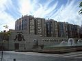
 City
City -
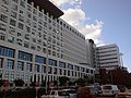 University Hospital of Gran Canaria
 -
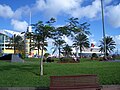
 Parque de San Telmo
 -
 Queen Mary 2 in Puerto de Las Palmas
 -
 "Lady Harimaguada"
 -
 One of the roads traversing Tafira Campus of the University of Las Palmas.
 -
 Panoramic view over Las Palmas
 -
 The Community of Canary Islands's government headquarters in Las Palmas de Gran Canaria


Sisters cities
|
Notable natives and residents
- Alfredo Kraus, was a Spanish tenor, one of the best tenors in the 20th century;
- Antonia San Juan, a Spanish actress, director and screenwriter;
- Antonio Betancort, football (soccer) player. Former goalkeeper of Real Madrid, Deportivo de La Coruña and U.D. Las Palmas;
- Benito Pérez Galdós, one of the best writers in the 19th century;
- Carla Suarez Navarro, tennis player;
- Francisco Kraus, Spanish Baritone, and a voice teacher;
- Javier Bardem, a famous Spanish actor (Academy Award-winning)
- Jerónimo Saavedra (Former Spanish Minister of Education and Science, Minister of Public Administrations of Spain, President of Canaries and now Mayor of Las Palmas de Gran Canaria);
- José Viera y Clavijo;
- Juan Carlos Valerón, football (soccer) player;
- Juan Fernando López Aguilar (Former Spanish Minister of Justice);
- Juan José Armas Marcelo, a Spanish writer;
- Juan Negrín, politician;
- Kira Miró, actress;
- Magüi Serna, tennis player;
- Manuel Pablo García Díaz, football (soccer) player;
- Marta Marrero, tennis player;
- Mateo Gil (writer and film director);
- Nicolás Estévanez, military officer, politician and poet;
- Sven Giegold, a German politician;
- Francisco Lorenzo Aparicio, aka Paco, currently the Las Palmas ambassador to Bristol UK, working to improve links between the two cities.
External links
 Definitions from Wiktionary
 Media from Commons
 News from Wikinews
 Quotations from Wikiquote
 Texts from Wikisource
 Textbooks from Wikibooks
 Resources from Wikiversity
- Info Las Palmas
- Auditorio Alfredo Kraus
- CAAM Modern Art Gallery
- Canarian Museum
- Canary Islands Exhibition Centre
- City Council
- Columbus House
- Cuyas Theater
- Las Palmas de Gran Canaria International Film Festival
- Las Palmas de Gran Canaria Theater and Dance Festival
- Nestor Museum
- Pérez Gáldos Theater
- Science and Technology Museum
- University of Las Palmas de Gran Canaria
- WebSite of the Las Canteras Beach
- Social Network of the Las Canteras Beach
- Club Vista Serena Hotel and Resort
References
- ^ Demographia: World Urban Areas
- ^ Eurostat - Urban Audit
- ^ European Spatial Planning Observation Network - Study on Urban Functions: Final Report, ISBN 2-9600467-2-2
- ^ Conurbaciones
- ^ Situación y Clima. Ayuntamiento de Las Palmas de Gran Canaria.
- ^ "Gran Canaria Weather – The best climate in the world". Retrieved 29 November 2008.
- ^ Real Decreto de 30 de noviembre de 1833 en wikisource
- ^ Real Decreto de 30 de noviembre de 1833 en el sitio web oficial del Gobierno de Canarias
- ^ Instituto Nacional de Estadística (Spain) - Datos Poblacionales del término municipal de Las Palmas de Gran Canaria. Avance del Padrón Municipal. Datos provisionales. [1], 1 January 2007
- ^ Weatherbase: Historical Weather for Las Palmas, Canary Islands
- ^ "Weather2Travel.com: Las Palmas Climate Guide".
{{cite web}}: Unknown parameter|dateformat=ignored (help) - ^ "[[World Meteorological Organization]]: Weather Information for Las Palmas".
{{cite web}}: URL–wikilink conflict (help); Unknown parameter|dateformat=ignored (help) - ^ "Gran Canaria Weather – The best climate in the world". Retrieved 29 November 2008.
- ^ según el propio ayuntamiento
- ^ www.grancanaria.com - Geographical information
- ^ "Weather Information for Las Palmas".
{{cite web}}: Unknown parameter|dateformat=ignored (help) - ^ Agustín Portillo Hahnefeld en Las Canteras y Bahía del Confital, Libro Blanco (op. cit.)
- ^ Guía de Playas, Ministerio de Medio Ambiente de España
- ^ «Cuando ya se dominaba el arte, se podía optar por otros lugares como La Barra, el Murro del Lloret o incluso El Confital, que se destaca en las revistas especializadas por la perfección de la ola que, no obstante, no está al alcance de cualquiera. (...) Los surferos de Las Canteras tienen el orgullo de decir que en 'El Confi', nombre por el que lo conocen, se origina la mejor ola 'de derecha' de Europa.» Barrera Artiles (op. cit., pp. 75 y 176.).
- ^ Entre el 8 y el 14 de octubre tendrá lugar en El Confital el certámen La Caja de Canarias-Ocean & Earth Pro 2007, prueba de categoría cuatro estrellas valedera para las clasificatorias mundiales masculinas de la ASP. Sitio web del evento
- ^ a b "Historia de Santa Brígida", Ayuntamiento de Santa Brígida
- ^ a b c "Lugares de interés histórico cultural de Santa Brígida", Cabildo de Gran Canaria
- ^ www.grancanaria.com "Discover Arucas"
- ^ mytravelguide.com
- ^ AENA passenger and aircraft movements for 2008
- ^ Space Shuttle Emergency Landing Sites
- ^ http://www.guaguas.com/
- ^ El tren de Gran Canaria pasará de la capital al sur de Gran Canaria
- ^ Official page of Real Club De Golf De Las Palmas
- ^ Las Palmas Gran Canaria y Rabat, hermanadas para promover desarrollo social
- ^ El Ayuntamiento de Las Palmas de Gran Canaria se hermana con Praia
| North: Atlantic Ocean | ||
| West: Arucas | Las Palmas de Gran Canaria | East: Atlantic Ocean |
| South: Santa Brígida and Telde |
Island capitals of the Canary Islands | ||
|---|---|---|
| Province of Santa Cruz de Tenerife | ||
| Province of Las Palmas | ||
| Governance |   | ||||||||
|---|---|---|---|---|---|---|---|---|---|
| Municipalities | |||||||||
| History | |||||||||
| Nature | |||||||||
| Landmarks and attractions |
| ||||||||
| Transport |
| ||||||||
| Sport | |||||||||
| Education and science | |||||||||