Lumbini: Difference between revisions
clean up and general fixes using AWB (7756) |
mNo edit summary |
||
| Line 42: | Line 42: | ||
===By Bus=== |
===By Bus=== |
||
It's 10 |
It's a 10 hour drive from the capital city Kathmandu. |
||
==Gallery== |
==Gallery== |
||
Revision as of 03:02, 20 June 2011
This article needs additional citations for verification. (March 2011) |
- For the zone of Nepal, see Lumbini Zone.
| UNESCO World Heritage Site | |
|---|---|
 | |
| Criteria | Cultural: iii, vi |
| Reference | 666 |
| Inscription | 1997 (21st Session) |
Lumbinī (Sanskrit: लुम्बिनी, "the lovely") is a Buddhist pilgrimage site in the Rupandehi district of Nepal. It is the place where Queen Mayadevi gave birth to Siddhartha Gautama, who as the Buddha Gautama founded the Buddhist tradition. The Buddha lived between roughly 563 and 483 BCE. Lumbini is one of four magnets for pilgrimage that sprang up in places pivotal to the life of the Buddha, the others being at Kushinagar, Bodh Gaya, and Sarnath.
Lumbini is in the foothills of the Himalaya,[1] 25 km east of the municipality of Kapilavastu, where the Buddha is said to have lived till the age of 29. Kapilvastu is the name of the place in question as well as of the neighbouring district. Lumbini has a number of temples, including the Mayadevi temple, and others under construction. Also here is the Puskarini or Holy Pond - where the Buddha's mother took the ritual dip prior to his birth and where he, too, had his first bath - as well as the remains of Kapilvastu palace. At other sites near Lumbini, earlier Buddhas were, according to tradition, born, achieved ultimate awakening and finally relinquished earthly form.

In Buddha's time
| Pilgrimage to |
| Buddha's Holy Sites |
|---|
 |
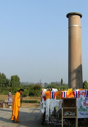
In the Buddha's time, Lumbini was a park situated between Kapilavastu and Devadaha in Nepal.[2] It was there that the Buddha was born.[3] A pillar now marks the spot of Asoka's visit to Lumbiní. According to an inscription on the pillar, it was placed there by the people then in charge of the park to commemorate Asoka's visit and gifts.[4] The park was previously known as Rummindei, two miles north of Bhagavanpura.
In the Sutta Nipáta (vs. 683) it is stated that the Buddha was born in a village of the Sákyans, in the Lumbineyya Janapada. The Buddha stayed in Lumbinívana during his visit to Devadaha and there preached the Devadaha Sutta.[5]
Re-discovery
In 1896, Nepalese archaeologists (effort by Khadga Samsher Rana) discovered a great stone pillar at the site, attributed to Emperor Ashoka. Records made by the Chinese pilgrim Fa Xian were also used in the process of identifying this religiously acclaimed site.
Present-day
Lumbini, as of 1997, is an UNESCO World Heritage Site specifically nominated for the international World Heritage program.
The holy site of Lumbini is bordered by a large monastic zone, in which only monasteries can be built, no shops or hotels or restaurants. It is separated into an eastern and western monastic zone, the eastern having the Theravadin monasteries, the western having Mahayana and Vajrayana monasteries.
The holy site of Lumbini has ruins of ancient monasteries, a sacred Bodhi tree, an ancient bathing pond, the Asokan pillar and the Mayadevi temple, where the precise place of birth of Buddha is located. From early morning to early evening, pilgrims from various countries perform chanting and meditation at the site.
Transport
By air
The closest airport is at Siddharthanagar, where are flights to and from Kathmandu are served.
By Bus
It's a 10 hour drive from the capital city Kathmandu.
Gallery
-
Bodhi tree and pond at Lumbini
-
Exact birthplace of Gautama Buddha
-
Ashokan Pillar
-
Lumbini Garden
-
Eternal Peace Flame
-
Burmese Lokamani Cula Pagoda
-
Chinese Maitreya Temple
-
A mixture of Tibetan prayer flags and Korean lanterns near the Sacred Pool (Puskarni)
References
External links
- Template:Wikitravel
- Video guide to Lumbini Nepal
- Entry on Lumbini in the Dictionary of Pali Proper Names
- WelcomeNepal.com: Lumbini
- Buddhist studies: Pilgrimage: Lumbini - Birthplace of the Buddha
- Lumbini Photo Gallery
- Lumbini.info Lumbini photos, history, geography, annual festivals
- WorldHeritageSite.org/Lumbini
- World-Heritage-Tour.org 360° wraparound photos of Lumbini


