
Crimea: Difference between revisions
→Steppe: direct links |
expanding and adding the inhabitants |
||
| Line 36: | Line 36: | ||
The '''Crimean Peninsula''' ({{lang-ru|Крымский полуостров}}, {{lang-uk|Кримський півострів}}, {{lang-crh|Qırım yarımadası}}), also known simply as '''Crimea''', is a major land mass on the northern coast of the [[Black Sea]] that is almost completely surrounded by water. The [[peninsula]] is located just south of the [[Ukraine|Ukrainian]] mainland and west of the [[Russia]]n region of [[Kuban]]. It is surrounded by two seas: the [[Black Sea]] and the smaller [[Sea of Azov]] to the east. It is connected with the Ukrainian mainland by the [[Isthmus of Perekop]] and is separated from Kuban by the [[Strait of Kerch]]. The [[Arabat Spit]] is located to the northeast; a narrow strip of land that separates a system of lagoons named [[Sivash]] from the [[Sea of Azov]]. |
The '''Crimean Peninsula''' ({{lang-ru|Крымский полуостров}}, {{lang-uk|Кримський півострів}}, {{lang-crh|Qırım yarımadası}}), also known simply as '''Crimea''', is a major land mass on the northern coast of the [[Black Sea]] that is almost completely surrounded by water. The [[peninsula]] is located just south of the [[Ukraine|Ukrainian]] mainland and west of the [[Russia]]n region of [[Kuban]]. It is surrounded by two seas: the [[Black Sea]] and the smaller [[Sea of Azov]] to the east. It is connected with the Ukrainian mainland by the [[Isthmus of Perekop]] and is separated from Kuban by the [[Strait of Kerch]]. The [[Arabat Spit]] is located to the northeast; a narrow strip of land that separates a system of lagoons named [[Sivash]] from the [[Sea of Azov]]. |
||
Crimea—or the '''Tauric Peninsula''', as it was formerly known—has historically been at the boundary between the [[Classical antiquity|classical world]] and the [[Pontic-Caspian steppe]]. |
Crimea—or the '''Tauric Peninsula''', as it was formerly known—has historically been at the boundary between the [[Classical antiquity|classical world]] and the [[Pontic-Caspian steppe]]. Inhabited by the [[Thracians]] and North Iranian peoples, it was ruled by the Royal Scythian tribe since 7th century B.C., its southern fringe was colonised by the [[Greek colonies|ancient Greeks]], since the 5th century B.C. most of the peninsula formed part of the [[Bosporan Kingdom]], since 1st century B.C. a [[client state]] under the [[Roman Crimea|ancient Romans]], the [[Cherson (theme)|Byzantine Empire]], [[Kievan Rus']], [[Golden Horde]], and the [[Ottoman Empire]], while at the same time its interior was occupied by a changing cast of invading [[steppe nomads]], such as the [[Cimmerians]], [[Scythians]], [[Goths]], [[Bulgars]], [[Huns]], [[Khazars]], [[Kipchaks]], and the [[Golden Horde]]. |
||
Crimea and adjacent territories were united in the [[Crimean Khanate]] during the 15th to 18th century before falling to the [[Russian Empire]] and being organised as its [[Taurida Governorate|Taurida Oblast]] in 1783. In 1954, the [[Soviet Union|Soviet]] [[Crimean Oblast]] was transferred from [[Russian Soviet Federative Socialist Republic|Russia]] to [[Ukrainian Soviet Socialist Republic|Ukraine]]. It became the [[Autonomous Republic of Crimea]] within newly independent [[Ukraine]] in 1991, with [[Sevastopol]] having its own administration within Ukraine but outside of the Autonomous Republic. |
Crimea and adjacent territories were united in the [[Crimean Khanate]] during the 15th to 18th century before falling to the [[Russian Empire]] and being organised as its [[Taurida Governorate|Taurida Oblast]] in 1783. In 1954, the [[Soviet Union|Soviet]] [[Crimean Oblast]] was transferred from [[Russian Soviet Federative Socialist Republic|Russia]] to [[Ukrainian Soviet Socialist Republic|Ukraine]]. It became the [[Autonomous Republic of Crimea]] within newly independent [[Ukraine]] in 1991, with [[Sevastopol]] having its own administration within Ukraine but outside of the Autonomous Republic. |
||
Revision as of 10:37, 17 May 2014
Template:Three other uses 45°18′N 34°24′E / 45.3°N 34.4°E
 | |
| Geography | |
|---|---|
| Location | Eastern Europe |
| Coordinates | 45°18′N 34°24′E / 45.3°N 34.4°E |
| Adjacent to | Black Sea Sea of Azov |
| Area | 27,000 km2 (10,000 sq mi) |
| Highest elevation | 1,545 m (5069 ft) |
| Administration | |
| Demographics | |
| Demonym | Crimean |
| Population | 2.4 million |

The Crimean Peninsula (Russian: Крымский полуостров, Ukrainian: Кримський півострів, Crimean Tatar: Qırım yarımadası), also known simply as Crimea, is a major land mass on the northern coast of the Black Sea that is almost completely surrounded by water. The peninsula is located just south of the Ukrainian mainland and west of the Russian region of Kuban. It is surrounded by two seas: the Black Sea and the smaller Sea of Azov to the east. It is connected with the Ukrainian mainland by the Isthmus of Perekop and is separated from Kuban by the Strait of Kerch. The Arabat Spit is located to the northeast; a narrow strip of land that separates a system of lagoons named Sivash from the Sea of Azov.
Crimea—or the Tauric Peninsula, as it was formerly known—has historically been at the boundary between the classical world and the Pontic-Caspian steppe. Inhabited by the Thracians and North Iranian peoples, it was ruled by the Royal Scythian tribe since 7th century B.C., its southern fringe was colonised by the ancient Greeks, since the 5th century B.C. most of the peninsula formed part of the Bosporan Kingdom, since 1st century B.C. a client state under the ancient Romans, the Byzantine Empire, Kievan Rus', Golden Horde, and the Ottoman Empire, while at the same time its interior was occupied by a changing cast of invading steppe nomads, such as the Cimmerians, Scythians, Goths, Bulgars, Huns, Khazars, Kipchaks, and the Golden Horde.
Crimea and adjacent territories were united in the Crimean Khanate during the 15th to 18th century before falling to the Russian Empire and being organised as its Taurida Oblast in 1783. In 1954, the Soviet Crimean Oblast was transferred from Russia to Ukraine. It became the Autonomous Republic of Crimea within newly independent Ukraine in 1991, with Sevastopol having its own administration within Ukraine but outside of the Autonomous Republic.
Sovereignty and control of the peninsula became the subject of the ongoing 2014 Crimean crisis, a territorial dispute between Russia and Ukraine.
Name
The classical name Tauris or Taurica is from the Greek Ταυρική, after the peninsula's Scytho-Cimmerian inhabitants, the Tauri. Strabo and Ptolemy refer to the Strait of Kerch as the Bosporus Cimmerius, and to Cimmerium as the capital of the Taurida, whence the peninsula, or its easternmost part, was also named Promontorium Cimmerium.[2]
In English, the Crimean Khanate is referred to as Crim Tartary in the early modern period.[3] The Italian[4] form Crimea (and "Crimean peninsula") also becomes current during the 18th century,[5] gradually replacing the classical name of Tauric peninsula in the course of the 19th century. The omission of the definite article in English ("Crimea" rather than "the Crimea") becomes common during the later 20th century.
The name "Crimea" ultimately, via Italian, takes its origin with the name of Qırım (today's Stary Krym) which served as a capital of the Crimean province of the Golden Horde. The name of the capital was extended to the entire peninsula at some point during Ottoman suzerainty.[6] The origin of the name Qırım itself is uncertain. It is mostly explained as:
- a corruption of Cimmerium.[7]
- a derivation from the Greek Cremni (κρήμνοι kremnoi "cliffs", mentioned in Herodotus 4.20).
- a derivation from the Mongolian appellation[8] kerm designating "wall", which, however, is phonetically incompatible with the original Mongolian literal appellation of the Crimean peninsula Qaram.[9]
- a derivation from the Crimean Tatar Turkic appellation Qırım designating "fortress" or "fosse", from the Turkic term qurum/qurimaq ("defense, protection").[9][10]
The classical name was revived in the name of the Russian Taurida Governorate.[11] While it was abandoned in the Soviet Union, and has had no official status since 1921, it is still used by some institutions in Crimea, such as the Taurida National University, or the Tavriya Simferopol football club.
History


In ancient times, it was the home of Cimmerians and Scythians, as well as the site of Greek colonies. The most important city was Chersonesos at the edge of today's Sevastopol.
Later occupiers included the Romans, Goths, Huns, Bulgars, Khazars, the state of Kievan Rus', the Byzantine Empire, the Kipchaks, and the Golden Horde. In the 13th century, portions were controlled by the Republic of Venice and by the Republic of Genoa.
In the 9th century, Byzantium established the Cherson theme to fend against incursions by the Rus' Khaganate, and the Crimean peninsula from this time was contested between Byzantium, Rus' and Khazaria. The area remained the site of overlapping interests and contact between the early medieval Slavic, Turkic and Greek spheres, and became a center of slave trade in particular, the word slave itself deriving from the ethnonym of the Slavs who were sold to the Muslim world and Byzantium during this period. In the 1230s, this status quo was swept away by the Mongol invasions, and Crimea was incorporated into the territory of the Golden Horde throughout the 14th century.

The Crimean Khanate, a vassal state of the Ottoman Empire, succeeded the Golden Horde and lasted from 1449 to 1779.[12] Until the late 18th century, Crimean Tatars maintained a massive slave trade with the Ottoman Empire, exporting about 2 million slaves from Russia and Ukraine over the period 1500–1700.[13] The Khanate was conquered by the Russian Empire under Catherine the Great in 1783. From 1853 to 1856, the peninsula was the site of the principal engagements of the Crimean War, a conflict fought between the Russian Empire and an alliance of France, Britain, the Ottoman Empire, and Sardinia.
During the Russian Civil War, Crimea was controlled by the White Army. After they were defeated by the Red Army, Crimea became part of the Soviet Union in 1921 as Crimean Autonomous Soviet Socialist Republic. In the Second World War the peninsula was occupied by Nazi Germany from July 1942-May 1944.
In 1954, it was transferred to the Ukrainian Soviet Socialist Republic within the Soviet Union.[14] In 1991, it became part of independent Ukraine as the Autonomous Republic of Crimea. As a result of the 2014 Crimean crisis, the accompanying Russian military intervention and the Crimean status referendum, 2014, the sovereignty over the peninsula is currently disputed between Ukraine and the Russian Federation. The peninsula is de facto controlled by the Russian Federation, in the form of two federal subjects: the Republic of Crimea and the federal city of Sevastopol.
Geography
Crimea is located on the northern coast of the Black Sea and on the western coast of the Sea of Azov, bordering Ukraine's Kherson Oblast from the north.
The natural border between the Crimean Peninsula and the Ukrainian mainland is formed by the Sivash or "Rotten Sea", a large system of shallow lagoons. The peninsula is connected to the Kherson Oblast's Henichesk Raion, and thus the European mainland, via the Isthmus of Perekop, a strip of land about 5–7 kilometres (3.1–4.3 mi) wide, as well as by bridges over the narrow Chongar and Henichesk straits. The northern part of Arabat Spit is administratively part of Henichesk Raion in Kherson Oblast, including its two rural communities of Shchaslyvtseve and Strilkove. The eastern tip of the peninsula is the Kerch Peninsula, separated from Taman Peninsula on the Russian mainland by the Kerch Strait, which connects the Black Sea with the Sea of Azov, at a width of between 3–13 kilometres (1.9–8.1 mi).
Geographically, the peninsula is generally divided into three zones: steppe, mountains and southern coast.
Coastline

The Crimean peninsula comprises many smaller peninsulas, such as the mentioned Kerch peninsula, Heracles Peninsula, Tarhankut Peninsula and many others. Crimea also possesses lots of headlands such as Cape Priboiny, Cape Tarkhankut, Sarych, Cape Fonar, Kazantyp, Cape Akburun, and many others.
The Crimean coastline is broken by several bays and harbors. These harbors lie west of the Isthmus of Perekop by the Bay of Karkinit; on the southwest by the open Bay of Kalamita between the port cities of Eupatoria and Sevastopol.
The Kerch Peninsula is attached to the Crimean mainland by Isthmus of Yenikale, delimited by the Bay of Arabat to the north (interrputed by the incoming Arabat Spit), and the Bay of Caffa[citation needed] to the south (arching eastward from the port of Feodosiya).
Crimean Mountains

The southeast coast is flanked at a distance of 8–12 kilometres (5.0–7.5 mi) from the sea by a parallel range of mountains, the Crimean Mountains.[15] These mountains are backed by secondary parallel ranges.
The main range of these mountains shoots up with extraordinary abruptness from the deep floor of the Black Sea to an altitude of 600–750 metres (1,969–2,461 ft), beginning at the southwest point of the peninsula, called Cape Fiolente. It was believed that this cape was supposedly crowned with the temple of Artemis, where Iphigeneia is said to have officiated as priestess.[16] Uchan-su waterfall on the south slope of the mountains is the highest in Ukraine.
Steppe
Seventy-five percent of the remaining area of Crimea consists of semiarid prairie lands, a southward continuation of the Pontic-Caspian steppe, which slope gently to the northwest from the foot of the Crimean Mountains. Numerous kurgans, or burial mounds, of the ancient Scythians are scattered across the Crimean steppes.
Crimean Riviera

The terrain that lies beyond the sheltering Crimean Mountain range is of an altogether different character. Here, the narrow strip of coast and the slopes of the mountains are smothered with greenery. This "riviera" stretches along the southeast coast from capes Fiolente and Aya, in the south, to Feodosiya, and is studded with summer sea-bathing resorts such as Alupka, Yalta, Gurzuf, Alushta, Sudak, and Feodosiya. During the years of Soviet rule, the resorts and dachas of this coast served as the prime perquisites of the politically loyal.[citation needed]why here? and ref? In addition, vineyards and fruit orchards are located in the region. Fishing, mining, and the production of essential oils are also important. Numerous Crimean Tatar villages, mosques, monasteries, and palaces of the Russian imperial family and nobles are found here, as well as picturesque ancient Greek and medieval castles.
Climate
Most of Crimea has a temperate continental climate, except for the south coast where it experiences a humid subtropical climate[citation needed], due to warm influences from the Black Sea and the high ground of the Crimean Mountains. Summers can be hot (28 °C (82.4 °F)* Jul average) and winters are cool (−0.3 °C (31.5 °F)* Jan average) in the interior, on the south coast winters are milder (4 °C (39.2 °F)* Jan average) and temperatures much below freezing are exceptional. On the high ground, freezing weather is common in winter. Precipitation throughout Crimea is low, averaging only 400 mm (15.7 in) a year. The Crimean coast is shielded from the north winds by the mountains, and as a result usually has mild winters. Cool season temperatures average around 7 °C (44.6 °F) and it is rare for the weather to drop below freezing except in the mountains, where there is usually snow.[17] Because of its climate, the southern Crimean coast is a popular beach and sun resort for Ukrainian and Russian tourists.
Strategic value

The Black Sea ports of Crimea provide quick access to the Eastern Mediterranean, Balkans and Middle East. Historically, possession of the southern coast of Crimea was sought after by most empires of the greater region since antiquity (Roman, Byzantine, Ottoman, Russian, British and French, Nazi German, Soviet).[18]
The Dnieper River is a major waterway and transportation route that crosses the European continent from north to south and ultimately links the Black Sea with the Baltic Sea, of strategic importance since the historical trade route from the Varangians to the Greeks. The Black Sea serves as an economic thoroughfare connecting the Caucasus region and the Caspian Sea to central and Eastern Europe.[19]
According to the International Transport Workers' Federation, in 2013 there were at least 12 operating merchant seaports in Crimea.[20]
Within 200 nautical miles of the Crimean shoreline there's an estimated 45 trillion cubic meters of gas reserves.[21] Hydrocarbons in the Black Sea shelf could yield as much as 1.5 billion cubic meters per year.[22]
Economy
This section is missing information about Crimea's GDP distribution by economic sector. (March 2014) |

The main branches of the Crimean economy are tourism and agriculture.[citation needed] Industrial plants are situated for the most part in the northern regions of the republic. Important industrial cities include Dzhankoy, housing a major railway connection, Krasnoperekopsk and Armyansk, among others.
The most important industries in Crimea include food production, chemical fields, mechanical engineering and metal working, and fuel production industries.[23] Sixty percent of the industry market belongs to food production. There are a total of 291 large industrial enterprises and 1002 small business enterprises.[23]
Agriculture in the region includes cereals, vegetable-growing, gardening, and wine-making, particularly in the Yalta and Massandra regions. Livestock production includes cattle breeding, poultry keeping, and sheep breeding.[23] Other products produced on the Crimean Peninsula include salt, porphyry, limestone, and ironstone (found around Kerch).[24]
Energy
Crimea also possesses several natural gas fields both onshore and offshore, all connected to Ukraine's pipeline system and were starting to be drilled by western oil and gas companies before annexation.[25][26] The inland fields are located in Chornomorske and Dzhankoy, while offshore fields are located in the western coast in the Black Sea and in the northeastern coast in the Azov Sea:[27]
The republic also possesses two oil fields: one onshore, the Serebryankse oil field in Rozdolne, and one offshore, the Subbotina oil field in the Black Sea.
Infrastructure
This section lacks an overview of its topic. (March 2014) |


- Public transportation
Almost every settlement in Crimea is connected with another settlement with bus lines. Crimea contains the longest (96 km or 59 mi) trolleybus route in the world, stretching from Simferopol to Yalta.[29] The trolleybus line starts near Simferopol's Railway Station through the mountains to Alushta and on to Yalta. The length of line is about 90 km. It was founded in 1959.
Railroad lines running through Crimea include Armyansk—Kerch (with a link to Feodosiya), and Melitopol—Sevastopol (with a link to Yevpatoria), connecting Crimea to the Ukrainian mainland.
- Highways
- E105/M18 - Syvash (bridge, starts), Dzhankoy, North Crimean Canal (bridge), Simferopol, Alushta, Yalta (ends)
- E97/M17 - Perekop (starts), Armyansk, Dzhankoy, Feodosiya, Kerch (ferry, ends)
- H05 - Krasnoperekopsk, Simferopol (access to the Simferopol International Airport)
- H06 - Simferopol, Bakhchisaray, Sevastopol
- H19 - Yalta, Sevastopol
- P16
- P23 - Simferopol, Feodosiya
- P25 - Simferopol, Yevpatoria
- P27 - Sevastopol, Inkerman (completely within the city of Sevastopol)
- P29 - Alushta, Sudak, Feodosiya
- P34 - Alushta, Yalta
- P35 - Hrushivka, Sudak
- P58 - Sevastopol, Port "Komysheva Bukhta" (completely within the city of Sevastopol)
- P59 (completely within the city of Sevastopol)
- Sea transport
The cities of Yalta, Feodosiya, Kerch, Sevastopol, Chornomorske and Yevpatoria are connected to one another by sea routes. In the cities of Yevpatoria and nearby townlet Molochnoye are tram systems.
Tourism
.jpg)

The development of Crimea as a holiday destination began in the second half of the 19th century. The development of the transport networks brought masses of tourists from central parts of the Russian Empire. At the beginning of the 20th century, a major development of palaces, villas, and dachas began—most of which remain. These are some of the main attractions of Crimea as a tourist destination. There are many Crimean legends about famous touristic places, which attract the attention of tourists.
A new phase of tourist development began when the Soviet government realized the potential of the healing quality of the local air, lakes and therapeutic muds. It became a "health" destination for Soviet workers, and hundreds of thousands of Soviet tourists visited Crimea.
Artek is a former Young Pioneer camp on the Black Sea in the town of Hurzuf, near Ayu-Dag, established in 1925. In 1969 it had an area of 3.2 km². The camp consisted of 150 buildings Unlike most of the young pioneer camps, Artek was an all-year camp, due to the warm climate. Artek was considered to be a privilege for Soviet children during its existence, as well as for children from other communist countries. During its heyday, 27,000 children a year vacationed at Artek. Between 1925 and 1969 the camp hosted 300,000 children.[30] After the breaking up of the Young Pioneers in 1991 its prestige declined, though it remained a popular vacation destination.[31]
In the 1990s, Crimea became more of a get-away destination than a "health-improvement" destination. The most visited areas are the south shore of Crimea with cities of Yalta and Alushta, the western shore - Eupatoria and Saki, and the south-eastern shore - Feodosia and Sudak. According to National Geographic, Crimea was among the top 20 travel destinations in 2013.[32]
Crimea possesses significant historical and natural resources and is a region where it is possible to find practically any type of landscape; mountain ranges and plateaus, grasslands, caves. Furthermore, Saki poses unique therapeutic mud and Eupatoria has vast empty beaches with the purest quartz sand.[33]
Places of interest include
Demographics
As of 2007, the estimate of the total population of the Autonomous Republic of Crimea and Sevastopol was at 2.352 million people,[34] just slightly down from the count of the 2001 Ukrainian Census at 2.376 million.[35]

The ethnic makeup of the population is comprised the following self-reported groups (2001 census):
- Russians:1,450,000 (58.5%),
- Ukrainians: 577,000 (24.0%),
- Crimean Tatars: 245,000 (10.2%),
- Belarusians: 35,000 (1.4%),
- Volga Tatars: 13,500 (0.5%),
- Armenians: 10,000 (0.4%),
- Jews: 5,500 (0.2%).[36]
According to the 2001 census, 77% of Crimean inhabitants named Russian as their native language; 11.4% – Crimean Tatar; and 10.1% – Ukrainian.[37]
Ethnic composition of Crimea's population has changed dramatically since the early 20th century. The 1879 Russian Empire Census for the Taurida Governorate reported: 194,294 (35.55%) Crimean Tatars, 180,963 (33.11%) Russians and 64,703 (11.84%) Ukrainians.
| Ethnic group |
1897 census | 1939 census | 1959 census[citation needed] | 1979 census | 1989 census[36] | 2001 census[36] | ||||||
|---|---|---|---|---|---|---|---|---|---|---|---|---|
| Number | % | Number | % | Number | % | Number | % | Number | % | Number | % | |
| Russians | 180,963 | 33.11% | 49.6% | 71.4% | 68.4% | 65.6% | 1,180,441 | 58.5% | ||||
| Ukrainians | 64,703 | 11.84% | 13.7% | 22.3% | 25.6% | 26.7% | 492,227 | 24.4% | ||||
| Crimean Tatars | 194,294 | 35.55% | 19.4% | 0% | 0.7% | 1.9% | 243,433 | 12.1% | ||||
| Others | ||||||||||||
Crimean Tatars, a predominantly Muslim ethnic minority who in 2001 made up 12.1% of the population,[38] formed in Crimea in the late Middle Ages, after the Crimean Khanate had come into existence. The Crimean Tatars were forcibly expelled to Central Asia by Joseph Stalin's government as a form of collective punishment, on the grounds that they had formed pro-German Tatar Legions. After the fall of the Soviet Union, Crimean Tatars began to return to the region.[39] According to the 2001 Ukrainian population census 58% of the population of Crimea are ethnic Russians and 24% are ethnic Ukrainians.[38]
Jews in Crimea were historically Krymchaks and Karaites (the latter a small group centered at Yevpatoria). The 1879 census for the Taurida Governorate reported a Jewish population of 4.20%, not including a Karaite population of 0.43%. The Krymchaks (but not the Karaites) were targeted for annihilation during Nazi occupation.
The number of Crimea Germans was 60,000 in 1939. During WWII, they were forcibly deported on the orders of Stalin, as they were regarded as a potential "fifth column".[40][41][42] This was part of the 800,000 Germans in Russia who were relocated within the Soviet Union during Stalinist times.[43] The 2001 Ukrainian census reports just 2,500 ethnic Germans (0.1% of population) in Crimea.
Besides the Crimean Germans, Stalin in 1944 also deported 70,000 Greeks, 14,000 Bulgarians[44] and 3,000 Italians.
Culture

Ivan Aivazovsky, the 19th century marine painter of Armenian origin, who is considered one of the major artists of his era was born in Feodosia and lived there for the most part of his life. Many of his paintings depict the Black Sea. He also created battle paintings during the Crimean War.[45]
Almost 100 broadcasters and around 1,200 publications are registered in Crimea, although no more than a few dozen operate or publish regularly.[46] Of them most use the Russian language only.[46] Crimea's first Tatar-owned, Tatar-language TV launched in 2006.[46]
Crimea was the background for Adam Mickiewicz's seminal work, The Crimean Sonnets. A series of 18 sonnets constitute an artistic telling of a journey through the Crimea, they feature romantic descriptions of the oriental nature and culture of the East which show the despair of an exile longing for the homeland, driven from his home by a violent enemy.
-
 People at the Kazantip music festival in 2007.
 -
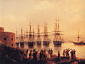 Painting of the Russian squadron in Sevastopol by Ivan Aivazovsky (1846)
 -
 The grave of Russian poet and artist Maximilian Voloshin

.JPG)

Gallery
-

-

-

-
 Catholic church in Yalta
 -
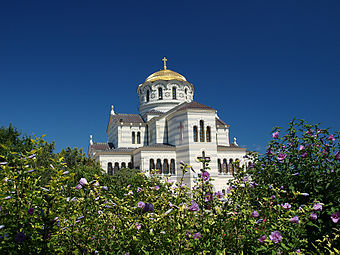 St. Vladimir's Cathedral, dedicated to the Heroes of Sevastopol (Crimean War).


See also
References
- ^ "Treaty to accept Crimea, Sevastopol to Russian Federation signed". rt.com. Autonomous Nonprofit Organization “TV-Novosti”. March 18, 2014. Retrieved 24 March 2014.
- ^ An universal history, from the earliest accounts to the present time, vol. 9 (1779), p. 127.
- ^ Edward Gibbon, The History of the Decline and Fall of the Roman Empire, Volume 1, 306f. "the peninsula of Crim Tartary, known to the ancients under the name of Chersonesus Taurica"; ibid. Volume 10 (1788), p. 211: "The modern reader must not confound this old Cherson of the Tauric or Crimean peninsula with a new city of the same name". see also John Millhouse, English-Italian (1859), p. 597
- ^ la Crimea since at least the 17th century. Maiolino Bisaccioni, Giacomo Pecini, Historia delle guerre ciuili di questi vltimi tempi, cioe, d'Inghilterra, Catalogna, Portogallo, Palermo, Napoli, Fermo, Moldauia, Polonia, Suizzeri, Francia, Turco. per Francesco Storti. Alla Fortezza, sotto il portico de'Berettari, 1655, p. 349: "dalla fortuna de Cosacchi dipendeva la sicurazza della Crimea". Nicolò Beregani, Historia delle guerre d'Europa, Volume 2 (1683), p. 251.
- ^ J. Dodsley, The annual register or a view of the history, politics, and literature for the year 1783 (1785), p. 364.
- ^ W. Radloff, Versuch eines Wörterbuches der Türk-Dialecte (1888), ii. 745
- ^ Cimmerium in Encyclopedia Britannica 4th edition (1810). Alexander MacBean, Samuel Johnson, Cimmerium in A Dictionary of Ancient Geography (1773).
- ^ Adrian Room, Placenames of the World, 2003, p. 96. Asimov, Isaac (1991). Asimov's Chronology of the World. New York: HarperCollins. p. 50.. See also William Smith, Dictionary of Greek and Roman Geography, 1854
- ^ a b Edward Allworth, The Tatars of Crimea: Return to the Homeland : Studies and Documents, Duke University Press, 1998, pp. 5-7
- ^ George Vernadsky, Michael Karpovich, A History of Russia, Yale University Press, 1952, p. 53. Quote:
- "The name Crimea is to be derived from the Turkish word qirim (hence the Russian krym), which means "fosse" and refers more specifically to the Perekop Isthmus, the old Russian word perekop being an exact translation of the Turkish qirim."
- ^ Edith Hall, Adventures with Iphigenia in Tauris (2013), p. 176: "it was indeed at some point between the 1730s and the 1770s that the dream of recreating ancient 'Taurida' in the southern Crimea was conceived. Catherine's plan was to create a paradisiacal imperial 'garden' there, and her Greek archbishop Eugenios Voulgaris obliged by inventing a new etymology for the old name of Tauris, deriving it from taphros, which (he claimed) was the ancient Greek for a ditch dug by human hands."
- ^ Brian Glyn Williams (2013). "The Sultan's Raiders: The Military Role of the Crimean Tatars in the Ottoman Empire" (PDF). The Jamestown Foundation. p. 27.
- ^ Darjusz Kołodziejczyk, as reported by Mikhail Kizilov (2007). "Slaves, Money Lenders, and Prisoner Guards:The Jews and the Trade in Slaves and Captivesin the Crimean Khanate". The Journal of Jewish Studies. p. 2.
- ^ "Ukraine and the west: hot air and hypocrisy". The Guardian. March 10, 2014.
- ^ The Crimean Mountains may also be referred to as the Yaylâ Dağ or Alpine Meadow Mountains.
- ^ See the article "Crimea" in the Encyclopædia Britannica Eleventh Edition.
- ^ "Climate in Crimea,Weather in Yalta:How Often Does it Rain in Crimea?". Blacksea-crimea.com. Retrieved 2014-04-10.
- ^ "What is the Crimea, and why does it matter?". Telegraph.co.uk. 2014-03-02. Retrieved 2014-04-10.
- ^ "Crimea Annexation 'Robbery on International Scale'". CBN News. CBN News. 2014-03-19. Retrieved 19 March 2014.
- ^ "Черное море признано одним из самых неблагоприятных мест для моряков". International Transport Workers' Federation. BlackSeaNews. 2013-05-27. Retrieved 20 September 2013.
- ^ "The Crimea Crisis -- Cui Bono?". American Thinker. American Thinker. 2014-04-01. Retrieved April 5, 2014.
- ^ "Heated issue: Russia to construct gas pipeline to Crimea". RT. RT. 2014-04-01. Retrieved April 1, 2014.
- ^ a b c "Autonomous Republic of Crimea – Information card". Cabinet of Ministers of Ukraine. Archived from the original on 2007-01-21. Retrieved February 22, 2007.
- ^ Bealby, John T. (1911). Encyclopædia Britannica Eleventh Edition. Cambridge University Press. p. 449.
- ^ Gloystein, Henning (7 March 2014). "Ukraine's Black Sea gas ambitions seen at risk over Crimea". Reuters. Retrieved 7 March 2014.
- ^ "East European Gas Analysis - Ukrainian Gas Pipelines". Eegas.com. 2013-02-09. Retrieved 2014-03-08.
- ^ "Ukraine crisis in maps". BBC. 5 March 2014. Retrieved 7 March 2014.
- ^ "Investment portal of the Autonomous Republic of Crimea – investments in Crimea - "Chernomorneftegaz" presented a program of development till 2015". Invest-crimea.gov.ua. Retrieved 2014-03-08.
- ^ "The longest trolleybus line in the world!". blacksea-crimea.com. Retrieved January 15, 2007.
- ^ Great Soviet Encyclopedia, 3rd ed., Entry on Artek
- ^ The International Children Center Artek - Ukrainian tours
- ^ Best Trips 2013 Crimea, National Geographic Society
- ^ "Crimea Travel Guide". CrimeaTravel. Retrieved 2012-12-25.
- ^ Autonomous Republic of Crimea: 1,973,185, Sevastopol: 379,200
- ^ Autonomous Republic of Crimea: 2,033,700, Sevastopol: 342,451. "Regions of Ukraine / Autonomous Republic of Crimea". 2001 Ukrainian Census. Retrieved December 16, 2006.
- ^ a b c this combines the figures for the Autonomous Republic of Crimea and Sevastopol, listing groups of more than 5,000 individuals. "Autonomous Republic of Crimea". 2001 Ukrainian Census. Retrieved 2014-03-24.; "Sevastopol". 2001 Ukrainian Census. Retrieved 2014-03-24.
- ^ "Results / General results of the census / Linguistic composition of the population / Autonomous Republic of Crimea". 2001 Ukrainian Census.
- ^ a b About number and composition population of AUTONOMOUS REPUBLIC OF CRIMEA by data All-Ukrainian population census', Ukrainian Census (2001)
- ^ Pohl, J. Otto. The Stalinist Penal System: A Statistical History of Soviet Repression and Terror. Mc Farland & Company, Inc, Publishers. 1997. 23.
- ^ "The Deportation and Destruction of the German Minority in the USSR" (PDF)
- ^ "On Germans Living on the Territory of the Ukrainian SSR"
- ^ "NKVD Arrest List" (PDF)
- ^ "A People on the Move: Germans in Russia and in the Former Soviet Union: 1763 – 1997. North Dakota State University Libraries.
- ^ "The Persecution of Pontic Greeks in the Soviet Union" (PDF)
- ^ Rogachevsky, Alexander. "Ivan Aivazovsky (1817-1900)". Tufts University. Retrieved 10 December 2013.
- ^ a b c Regions and territories: The Republic of Crimea, BBC News
