Qasr el Banat, Lebanon: Difference between revisions
m WP:CHECKWIKI error fix for #61. Punctuation goes before References. Do general fixes if a problem exists. - using AWB (11756) |
Rescuing 1 sources and tagging 1 as dead. #IABot (v1.1) |
||
| Line 53: | Line 53: | ||
*[http://www.panoramio.com/photo/8531734 Photo of the temple at Qasr el Banat on panoramio.com] |
*[http://www.panoramio.com/photo/8531734 Photo of the temple at Qasr el Banat on panoramio.com] |
||
*[http://www.panoramio.com/photo/8532312 Photo of the view from Qasr el Banat on panoramio.com] |
*[http://www.panoramio.com/photo/8532312 Photo of the view from Qasr el Banat on panoramio.com] |
||
*[http://travellersdata.com/lebanon/visiting-deir-el-ahmar-bekaa-valley.html Visiting Deir el Ahmar in Bekaa Valley, Lebanese Ministry of Tourism brochure] |
*[http://web.archive.org/web/20120918172559/http://travellersdata.com:80/lebanon/visiting-deir-el-ahmar-bekaa-valley.html Visiting Deir el Ahmar in Bekaa Valley, Lebanese Ministry of Tourism brochure] |
||
*[http://middleeast.com/qasrelbanaat.htm Qasr El-Banat on middleeast.com] |
*[http://middleeast.com/qasrelbanaat.htm Qasr El-Banat on middleeast.com] |
||
*[http://en.mapatlas.org/Lebanon/Ancient_Site/Qasr_al_Banat/3023/road_and_satellite_map Qasr el Banat on mapatlas.org] |
*[http://en.mapatlas.org/Lebanon/Ancient_Site/Qasr_al_Banat/3023/road_and_satellite_map Qasr el Banat on mapatlas.org]{{dead link|date=July 2016 |bot=InternetArchiveBot |fix-attempted=yes }} |
||
*[http://www.geographic.org/geographic_names/name.php?uni=6518329&fid=3644&c=lebanon Qasr el Banat on geographic.org] |
*[http://www.geographic.org/geographic_names/name.php?uni=6518329&fid=3644&c=lebanon Qasr el Banat on geographic.org] |
||
Revision as of 10:55, 21 July 2016
 | |
| Alternative name | Qasr el Banât, Qasr al Banat, Kasr el-Banat, Qasr El-Banaat |
|---|---|
| Region | Baalbek |
| History | |
| Cultures | Roman |
| Site notes | |
| Condition | Ruins |
| Public access | Yes |
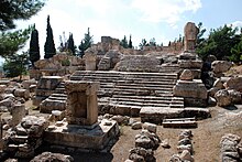
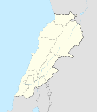
Qasr el Banat is an ancient temple situated 1.5 kilometres (0.93 mi) east of Chlifa in the Baalbek District of the Beqaa Governorate in Lebanon.[1][2] It is believed the site was called the castle of virgins and was the residence of virgins in Roman times.[3][4]
George F. Taylor classified Qasr el Banat among a group of Temples of the Beqaa Valley. It is suggested to date to Ancient Roman, Ancient Greek eras or earlier. The temple is located on a rocky plateau, accessible by a climb up a hill. The top of the hill is covered in various platforms, cisterns, tanks and steps that have been carved out of solid bedrock. Within the remains is a small antae temple, constructed of large square blocks that was used as a fortress in later times. Some sections remain intact built up two or three layers high. A basilica from a later period was built alongside the temple.[1]
There are two circular structures located around 100 metres (330 ft) southeast of the temple that are thought to have been examples of the high places referenced in the Bible.
References
- ^ a b George Taylor (1967). The Roman temples of Lebanon: a pictorial guide. Dar el-Machreq Publishers. Retrieved 1 November 2012.
- ^ Othmar Keel (1997). The Symbolism of the Biblical World: Ancient Near Eastern Iconography and the Book of Psalms. Eisenbrauns. pp. 158–. ISBN 978-1-57506-014-9. Retrieved 1 November 2012.
- ^ Gockel, Wolfgang; Bruns, Helga (1998-01-01). Syria - Lebanon. Hunter Publishing, Inc. ISBN 9783886181056.
- ^ Dau, Butros (1984-01-01). History of the Maronites: Relig[i]ous, Cultural, and Political. B. Dau.
External links
- Photo of the temple at Qasr el Banat on picasaweb
- Photo of the temple at Qasr el Banat on panoramio.com
- Photo of the temple at Qasr el Banat on panoramio.com
- Photo of the view from Qasr el Banat on panoramio.com
- Visiting Deir el Ahmar in Bekaa Valley, Lebanese Ministry of Tourism brochure
- Qasr El-Banat on middleeast.com
- Qasr el Banat on mapatlas.org[permanent dead link]
- Qasr el Banat on geographic.org

