
Bidston Hill: Difference between revisions
fix map display |
Rescuing 4 sources and tagging 0 as dead. #IABot (v1.2.6) |
||
| Line 67: | Line 67: | ||
'''Bidston Hill''' is {{convert|100|acre|km2}} of heathland and woodland that contains historic buildings and ancient rock carvings. It is located on the [[Wirral Peninsula]], near the [[Birkenhead]] suburb of [[Bidston]], in [[Merseyside]], [[England]]. |
'''Bidston Hill''' is {{convert|100|acre|km2}} of heathland and woodland that contains historic buildings and ancient rock carvings. It is located on the [[Wirral Peninsula]], near the [[Birkenhead]] suburb of [[Bidston]], in [[Merseyside]], [[England]]. |
||
With a peak of {{convert|231|ft|m}}, Bidston Hill is one of the highest points on the Wirral.<ref name="Metropolitan Borough of Wirral: Bidston Hill">{{cite web |url=http://www.wirral.gov.uk/my-services/leisure-and-culture/parks-beaches-and-countryside/parks-greenspaces-and-countryside/natural-areas-and-greenspaces |title=Natural Areas and Greenspaces: Bidston Hill |work=Metropolitan Borough of Wirral |accessdate=13 June 2010}}</ref><ref name="The Wirral Hundred/The Wirral Peninsula">{{cite web |url=http://www.mikekemble.com/mside/wirral.html |first=Mike |last=Kemble |title=The Wirral Hundred/The Wirral Peninsula |accessdate=12 August 2007 |archiveurl=https://web.archive.org/web/20070704202001/http://www.mikekemble.com/mside/wirral.html |archivedate=4 July 2007 <!--DASHBot--> |deadurl=no}}</ref> |
With a peak of {{convert|231|ft|m}}, Bidston Hill is one of the highest points on the Wirral.<ref name="Metropolitan Borough of Wirral: Bidston Hill">{{cite web |url=http://www.wirral.gov.uk/my-services/leisure-and-culture/parks-beaches-and-countryside/parks-greenspaces-and-countryside/natural-areas-and-greenspaces |title=Natural Areas and Greenspaces: Bidston Hill |work=Metropolitan Borough of Wirral |accessdate=13 June 2010}}</ref><ref name="The Wirral Hundred/The Wirral Peninsula">{{cite web |url=http://www.mikekemble.com/mside/wirral.html |first=Mike |last=Kemble |title=The Wirral Hundred/The Wirral Peninsula |accessdate=12 August 2007 |archiveurl=https://web.archive.org/web/20070704202001/http://www.mikekemble.com/mside/wirral.html |archivedate=4 July 2007 <!--DASHBot--> |deadurl=no}}</ref> |
||
The land was part of Lord Vyner's estate<ref>{{cite web |
The land was part of Lord Vyner's estate<ref>{{cite web|url=http://www.mikekemble.com/mside/bidston.html |title=Bidston Village, Hall, Hill & Mill |first=Mike |last=Kemble |accessdate=14 September 2009 |deadurl=yes |archiveurl=https://web.archive.org/web/20090725001445/http://www.mikekemble.com:80/mside/bidston.html |archivedate=25 July 2009 |df= }}</ref> |
||
and purchased by Birkenhead Corporation in 1894 for use by the public.<ref>{{cite book |title=Birkenhead: An Illustrated History |first=Ralph T. |last=Brocklebank |page=91 |year=2003 |publisher=Breedon Books |isbn=1-85983-350-0}}</ref> |
and purchased by Birkenhead Corporation in 1894 for use by the public.<ref>{{cite book |title=Birkenhead: An Illustrated History |first=Ralph T. |last=Brocklebank |page=91 |year=2003 |publisher=Breedon Books |isbn=1-85983-350-0}}</ref> |
||
| Line 74: | Line 74: | ||
=== Bidston Windmill === |
=== Bidston Windmill === |
||
[[Bidston Windmill]] replaced a wooden mill that was destroyed by fire in 1791,<ref name=kemble2>{{cite web |
[[Bidston Windmill]] replaced a wooden mill that was destroyed by fire in 1791,<ref name=kemble2>{{cite web|url=http://www.mikekemble.com/mside/bidston3.html |title=Bidston: The Mill |first=Mike |last=Kemble |accessdate=16 July 2010 |deadurl=yes |archiveurl=https://web.archive.org/web/20101010005116/http://www.mikekemble.com:80/mside/bidston3.html |archivedate=10 October 2010 |df= }}</ref><ref name=allerton>{{cite web|url=http://www.allertonoak.com/merseyThemes/Windmills.html |title=Windmills |publisher=Allerton Oak |accessdate=16 July 2010 |deadurl=yes |archiveurl=https://web.archive.org/web/20110223081659/http://www.allertonoak.com:80/merseyThemes/Windmills.html |archivedate=23 February 2011 |df= }}</ref><ref name=ordnance>{{citation |title=Old Ordnance Survey Map: Cheshire 13.02 (1909) |first=C.E. |last=Bidston |work=Alan Godfrey Maps}}</ref> |
||
and was used to grind wheat until about 1875. |
and was used to grind wheat until about 1875. |
||
However it is believed that there has been a windmill on this site since 1596.<ref name=kemble2/><ref name=allerton/> |
However it is believed that there has been a windmill on this site since 1596.<ref name=kemble2/><ref name=allerton/> |
||
| Line 84: | Line 84: | ||
Up to 18 July 1969, at exactly 1:00 p.m. each day, the 'One O'Clock Gun' overlooking the [[River Mersey]] near [[Morpeth Dock]], Birkenhead, would be fired electrically from the Observatory.<ref name=pol-gun>{{cite web |url=http://www.pol.ac.uk/home/history/gun.html |title=The Time Ball and the One O'clock Gun |work=Proudman Oceanographic Laboratory |accessdate=12 August 2007 |archiveurl=https://web.archive.org/web/20070927202715/http://www.pol.ac.uk/home/history/gun.html| archivedate=27 September 2007 <!--DASHBot--> |deadurl=no}}</ref> |
Up to 18 July 1969, at exactly 1:00 p.m. each day, the 'One O'Clock Gun' overlooking the [[River Mersey]] near [[Morpeth Dock]], Birkenhead, would be fired electrically from the Observatory.<ref name=pol-gun>{{cite web |url=http://www.pol.ac.uk/home/history/gun.html |title=The Time Ball and the One O'clock Gun |work=Proudman Oceanographic Laboratory |accessdate=12 August 2007 |archiveurl=https://web.archive.org/web/20070927202715/http://www.pol.ac.uk/home/history/gun.html| archivedate=27 September 2007 <!--DASHBot--> |deadurl=no}}</ref> |
||
In 1929 the work of the observatory was merged with the [[University of Liverpool]] Tidal Institute, being taken over in 1969 by the [[Natural Environment Research Council]]. |
In 1929 the work of the observatory was merged with the [[University of Liverpool]] Tidal Institute, being taken over in 1969 by the [[Natural Environment Research Council]]. |
||
The Research Council relocated the [[Proudman Oceanographic Laboratory]] to the University of Liverpool campus in 2004.<ref>{{cite web |
The Research Council relocated the [[Proudman Oceanographic Laboratory]] to the University of Liverpool campus in 2004.<ref>{{cite web|url=http://www.pol.ac.uk/home/documents/annual_report_2004_05.pdf |format=PDF |title=Proudman Oceanographic Laboratory Annual Report, 2004-05 (page 26) |work=Natural Environment Research Council |year=2005 |accessdate=11 February 2012 |deadurl=yes |archiveurl=https://web.archive.org/web/20120104112025/http://www.pol.ac.uk/home/documents/annual_report_2004_05.pdf |archivedate=4 January 2012 |df= }}</ref> |
||
=== Bidston Lighthouse === |
=== Bidston Lighthouse === |
||
Revision as of 21:59, 1 November 2016
| Bidston Hill | |
|---|---|
 Bidston Lighthouse | |
 | |
| Type | Common |
| Location | Bidston, Merseyside |
| Coordinates | 53°23′49″N 3°04′30″W / 53.397°N 3.075°W53°23′49″N 3°04′30″W / 53.397°N 3.075°W |
| Area | 100 acres (0.40 km2) |
| Operated by | Metropolitan Borough of Wirral |
| Open | All year |
| Status | Open |
 | |
 | |
| Location | Bidston, Metropolitan Borough of Wirral, United Kingdom |
|---|---|
| Coordinates | 53°23′51″N 3°04′31″W / 53.3975°N 3.0753°W |
| Constructed | 1771 (first) 1873 (second) |
| Construction | sandstone tower |
| Height | 21 metres (69 ft) |
| Shape | cylindrical tower with balcony and lantern attached to 1-storey keeper’s house |
| Markings | unpainted tower |
| Operator | Bidston Lighthouse[1] |
| Light | |
| Deactivated | 1913 (second) |
| Characteristic | decorative light |
Bidston Hill is 100 acres (0.40 km2) of heathland and woodland that contains historic buildings and ancient rock carvings. It is located on the Wirral Peninsula, near the Birkenhead suburb of Bidston, in Merseyside, England. With a peak of 231 feet (70 m), Bidston Hill is one of the highest points on the Wirral.[2][3] The land was part of Lord Vyner's estate[4] and purchased by Birkenhead Corporation in 1894 for use by the public.[5]
Buildings
Bidston Windmill
Bidston Windmill replaced a wooden mill that was destroyed by fire in 1791,[6][7][8] and was used to grind wheat until about 1875. However it is believed that there has been a windmill on this site since 1596.[6][7] After falling into disuse it was bought and restored from 1894. It is open on the first Saturday of each month from April to September, between 10:00 a.m. and 12:00 noon.[9]
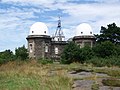
Bidston Observatory
Bidston Observatory was built in 1866 using local sandstone excavated from the site. One of its functions was to determine the exact time. Up to 18 July 1969, at exactly 1:00 p.m. each day, the 'One O'Clock Gun' overlooking the River Mersey near Morpeth Dock, Birkenhead, would be fired electrically from the Observatory.[10] In 1929 the work of the observatory was merged with the University of Liverpool Tidal Institute, being taken over in 1969 by the Natural Environment Research Council. The Research Council relocated the Proudman Oceanographic Laboratory to the University of Liverpool campus in 2004.[11]
Bidston Lighthouse
There has been a lighthouse on Bidston Hill since 1771. Being more than two miles from the sea, it depended on a breakthrough in lighthouse optics, which came in the form of the parabolic reflector, developed at the signals station on Bidston Hill by Liverpool's dockmaster William Hutchinson. The reflector at Bidston Lighthouse was thirteen-and-a-half feet in diameter, and the lamp consumed a gallon of oil every four hours.[12] The present lighthouse was built in 1873 and was operational until sunrise on 9 October 1913. Bidston and Leasowe Lighthouse together formed a pair of leading lights enabling ships to avoid the sandbanks in the channel to Liverpool.[13] It is now privately owned, and occasionally open to the public.[14]
Rock carvings

There is a 4+1⁄2-foot-long (1.4 m) carving of a Sun Goddess, carved into the flat rock north-east of the Observatory, supposedly facing in the direction of the rising sun on Midsummer's Day. and thought to have been carved by the Norse-Irish around 1000 AD. An ancient carving of a horse is located on bare rock to the north of the Observatory.[15]
Bidston Court
Robert William Hudson built a house called 'Bidston Court' on Vyner Road South near Bidston Hill in 1891. Germany's Crown Prince Wilhelm was so impressed with the house that in 1913 he built a similar house, the Cecilienhof in Potsdam. The house was sold in 1921 to Sir Ernest Royden and in 1928 was moved to its present site in Frankby, brick by brick, finally being completed in 1931. It was renamed 'Hill Bark'. The original site of the house was given to Birkenhead Corporation.[16]
Bidston Tunnels
During World War II, an air raid shelter was constructed at Bidston Hill. Today the tunnels are concealed for public safety.[17]
Gallery
-
 Summit and distance marker.
 -
 Bidston Windmill.
 -
 Bidston Observatory.
 -
 The former Joseph Proudman Building, demolished in 2013.


See also
References
- ^ Bidstone Hill The Lighthouse Directory. University of North Carolina at Chapel Hill. Retrieved April 29, 2016
- ^ "Natural Areas and Greenspaces: Bidston Hill". Metropolitan Borough of Wirral. Retrieved 13 June 2010.
- ^ Kemble, Mike. "The Wirral Hundred/The Wirral Peninsula". Archived from the original on 4 July 2007. Retrieved 12 August 2007.
{{cite web}}: Unknown parameter|deadurl=ignored (|url-status=suggested) (help) - ^ Kemble, Mike. "Bidston Village, Hall, Hill & Mill". Archived from the original on 25 July 2009. Retrieved 14 September 2009.
{{cite web}}: Unknown parameter|deadurl=ignored (|url-status=suggested) (help) - ^ Brocklebank, Ralph T. (2003). Birkenhead: An Illustrated History. Breedon Books. p. 91. ISBN 1-85983-350-0.
- ^ a b Kemble, Mike. "Bidston: The Mill". Archived from the original on 10 October 2010. Retrieved 16 July 2010.
{{cite web}}: Unknown parameter|deadurl=ignored (|url-status=suggested) (help) - ^ a b "Windmills". Allerton Oak. Archived from the original on 23 February 2011. Retrieved 16 July 2010.
{{cite web}}: Unknown parameter|deadurl=ignored (|url-status=suggested) (help) - ^ Bidston, C.E., "Old Ordnance Survey Map: Cheshire 13.02 (1909)", Alan Godfrey Maps
- ^ "Bidston Windmill". Friends of Bidston Hill Heritage Trail. Retrieved 13 March 2014.
- ^ "The Time Ball and the One O'clock Gun". Proudman Oceanographic Laboratory. Archived from the original on 27 September 2007. Retrieved 12 August 2007.
{{cite web}}: Unknown parameter|deadurl=ignored (|url-status=suggested) (help) - ^ "Proudman Oceanographic Laboratory Annual Report, 2004-05 (page 26)" (PDF). Natural Environment Research Council. 2005. Archived from the original (PDF) on 4 January 2012. Retrieved 11 February 2012.
{{cite web}}: Unknown parameter|deadurl=ignored (|url-status=suggested) (help) - ^ Robinson, John; Robinson, Diane (2007). Lighthouses of Liverpool Bay. The History Press. ISBN 978-0752442099.
- ^ "Bidston Lighthouse". Proudman Oceanographic Laboratory. Archived from the original on 27 September 2007. Retrieved 12 August 2007.
{{cite web}}: Unknown parameter|deadurl=ignored (|url-status=suggested) (help) - ^ "Bidston Lighthouse". Retrieved 5 May 2014.
- ^ "Bidston Hill". Metropolitan Borough of Wirral. Archived from the original on 28 June 2008. Retrieved 16 July 2010.
- ^ "Bidston Court". Geograph. Retrieved 11 March 2007.
- ^ "Bidston Hill Underground Tunnels". wirralhistory.co.uk. Archived from the original on 24 October 2008. Retrieved 9 September 2008.
{{cite web}}: Unknown parameter|deadurl=ignored (|url-status=suggested) (help)
External links
- Map sources for Bidston Hill
- Friends of Bidston Hill
- Bidston Lighthouse
- Bidston Village, Church, Hall, Hill & Mill