
Chingaza National Natural Park: Difference between revisions
JJMC89 bot (talk | contribs) Migrate {{Infobox protected area}} coordinates parameters to {{Coord}}, see Help:Coordinates in infoboxes |
Rescuing 1 sources and tagging 0 as dead. #IABot (v1.2.7.1) |
||
| Line 25: | Line 25: | ||
| designation1 = Ramsar |
| designation1 = Ramsar |
||
| designation1_offname = Sistema Lacustre de Chingaza |
| designation1_offname = Sistema Lacustre de Chingaza |
||
| designation1_date = June 25, 2008 <ref name="Ramsar list">{{cite web|title=Ramsar List|url=http://www.ramsar.org/cda/en/ramsar-documents-list/main/ramsar/1-31-218_4000_0__|publisher=Ramsar.org|accessdate=12 April 2013}}</ref> |
| designation1_date = June 25, 2008 <ref name="Ramsar list">{{cite web|title=Ramsar List |url=http://www.ramsar.org/cda/en/ramsar-documents-list/main/ramsar/1-31-218_4000_0__ |publisher=Ramsar.org |accessdate=12 April 2013 |deadurl=yes |archiveurl=https://web.archive.org/web/20130409081737/http://www.ramsar.org/cda/en/ramsar-documents-list/main/ramsar/1-31-218_4000_0__ |archivedate=9 April 2013 |df= }}</ref> |
||
}} |
}} |
||
}} |
}} |
||
Revision as of 15:29, 22 November 2016
| Chingaza Natural National Park | |
|---|---|
 Road in Chingaza National Park | |
 | |
| Location | Colombia |
| Coordinates | 4°28′N 73°44′W / 4.467°N 73.733°W |
| Area | 76,600 hectares (189,000 acres) |
| Established | 1977 |
| Governing body | SINAP |
| Official name | Sistema Lacustre de Chingaza |
| Designated | June 25, 2008 [1] |

Chingaza National Park is located in the Eastern Cordillera of the Andes, northeast of Bogotá, Colombia in the departments of Cundinamarca and Meta. The elevation in the park, to the east of the Altiplano Cundiboyacense, ranges from 800 metres (2,600 ft) to 4,020 metres (13,190 ft), and the temperature ranges from 4 °C to 21.5 °C.[2] The park extends over the Cundinamarca municipalities La Calera, Fómeque, Guasca and San Juanito (Meta).
Etymology
The name Chingaza comes from Chibcha and means "middle of the width".[3]
Hydrography
99% of the park area is located in the Orinoco River basin in the upper basins of the Black and White, Guatiquía, Guacavía, Gazaunta, Gazamumo, Humea and Guavio rivers. 1% of its area is in the Magdalena River basin, where the San Lorenzo Creek, La Calera River tributary, and Teusacá, Siecha, Bogotá, and Tominé rivers drain.
Chingaza has about 40 natural glacial lakes. The largest lake is Lake Chingaza, located in the southwestern part of the park at an altitude of 3,250 metres (10,660 ft). One of the most representative and culturally significant bodies of water are the Siecha Lakes, a group of three lakes in the municipality of Guasca. Chuza Reservoir is also located within the Chingaza Park in the basin of a tributary of the River Chuza Guatiquía. This reservoir is the center of the Bogotá Water Company's Chingaza System. Chingaza contributes 80% of the city's high quality drinking water.[4]
Viewing and wildlife
The animals found in Chingaza include spectacled bear, deer, tapir moor, pumas, Andean condors, Cock-of-the-rocks, jaguars, turkeys, woolly monkeys, nocturnal monkeys, ocelots, and toucans. The large number of endemic species makes the Eastern Cordillera one of the most important geographic regions for wildlife in Colombia.[2]
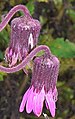
In the vicinity of the Chingaza lagoon, less than 383 species of plants have been recorded. It is estimated that the total flora of the park may exceed 2,000 species. There are eight species of peat moss, which can absorb up to 40 times their weight in water. There are also endemic species, such as frailejones, that grow on the páramo and even within forests.[4]
Communities present in the area
Indigenous
There are currently no indigenous groups within the territory of Chingaza. However, the area has historical importance, with over 10,000 years of Muisca and pre-Muisca inhabitation in the region. Ponds, rock shelters, the mountains and especially the Siecha Lakes were sacred places of worship and respect, forming ceremonial centers.[5] Recent studies indicate that Chingaza in the Chibcha language of the Muisca could have been called Chim-wa-za, which means "God's Night Mountains".[6]
Peasants
The population around the park forms a rural community with its own forms of organization, dynamic internal and external relationships, and cultural patterns that distinguish it from peasant communities in other regions.[6]
Named after Chingaza
- Araneus chingaza, a species of spider described in the Chingaza Natural National Park
- Polylobus chingaza, a species of beetle, idem
Gallery
-
 Clouds over Chingaza National Park
 -
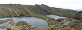 Siecha Lakes
 -
 Lake in the southern part of the park
 -


.jpg)
See also
References
- ^ "Ramsar List". Ramsar.org. Archived from the original on 9 April 2013. Retrieved 12 April 2013.
{{cite web}}: Unknown parameter|deadurl=ignored (|url-status=suggested) (help) - ^ a b Template:Es Website Chingaza Natural National Park - accessed 06-05-2016
- ^ Template:Es Etymology Chingaza
- ^ a b Template:Es Chingaza Natural National Park - GuiaTodo - accessed 06-05-2016
- ^ Ocampo López, Javier (2007). Grandes culturas indígenas de América (in Spanish). Bogotá, Colombia: Plaza & Janes Editores Colombia S.A. p. 226. ISBN 978-958-14-0368-4.
{{cite book}}: Unknown parameter|trans_title=ignored (|trans-title=suggested) (help) - ^ a b Template:Es Chingaza Natural National Park - Ministerio de Ambiente - accessed 06-05-2016
External links
- 2008 - Ramsar site: Chingaza
.svg)
Treasures of Colombia | |||||||||||||||||||||||||||||
|---|---|---|---|---|---|---|---|---|---|---|---|---|---|---|---|---|---|---|---|---|---|---|---|---|---|---|---|---|---|
| |||||||||||||||||||||||||||||
| |||||||||||||||||||||||||||||
| |||||||||||||||||||||||||||||
| |||||||||||||||||||||||||||||
Source: Wills, Fernando; et al. (2001). Nuestro patrimonio – 100 tesoros de Colombia [Our heritage – 100 treasures of Colombia] (in Spanish). El Tiempo. pp. 1–311. ISBN 958-8089-16-6. | |||||||||||||||||||||||||||||
| International | |
|---|---|
| National | |
| Other | |