Jump to content

Boyacá Department: Difference between revisions

From Wikipedia, the free encyclopedia
Content deleted Content added
Bluebot (talk | contribs)
Unicodifying
No edit summary
Line 2: Line 2:
|name=Boyacá
|name=Boyacá
|flag=Flag of Boyacá Department.svg
|flag=Flag of Boyacá Department.svg
|coa=blank.png
|coa=Escudo de Boyacá.jpg
|map=Boyacá, Colombia (localización).png
|map=Boyacá, Colombia (localización).png
|motto=
|motto=

Revision as of 19:55, 10 October 2006

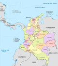
Template:CoDepartment infobox Boyacá is a department of Colombia, one of the original nine states of the "United States of Colombia".

Boyacá is centrally located within Colombia, almost entirely within the mountains of the Eastern Cordillera, although the western end of the department extends to the Magdalena River at the town of Puerto Boyacá. It has an area of 23,102 km² (8,880 sq mi). The capital city is Tunja.

Boyacá is known as "The Land of Freedom" because this region was the scene of the battles which won Colombia's independence from the Spanish. The first took place on 20 July 1810 in the Pantano de Vargas and the final and decisive battle was fought on 7 August 1819 at Puente de Boyacá.

Boyacá is home to three universities: the Universidad Pedagógica y Tecnológica de Colombia (UPTC), the Universidad de Boyacá (UNIBOYACA), and the Universidad Santo Tomás.

Postage stamps

See : Postage stamps of Boyacá

Provinces and Municipalities

There are 13 provinces and two special district in Boyacá Department. Listed here with their municipalities.

Centro

  1. Cómbita
  2. Cucaita
  3. Chiquiza
  4. Chivatá
  5. Motavita
  6. Oicatá
  7. Siachoque
  8. Samacá
  9. Sora
  10. Soracá
  11. Sotaquira
  12. Toca
  13. Tunja
  14. Tuta
  15. Ventaquemada

Norte

  1. Boavita
  2. Covarachía
  3. La Uvita
  4. San Mateo
  5. Sativanorte
  6. Sativasur
  7. Soatá
  8. Susacón
  9. Tipacoque

Occidente

  1. Briceño
  2. Buenavista
  3. Caldas
  4. Chiquinquirá
  5. Coper
  6. La Victoria
  7. Maripí
  8. Muzo
  9. Otanche
  10. Pauna
  11. Quipama
  12. Saboyá
  13. San Miguel de Sema
  14. San Pablo de Borbur
  15. Tununguá

Oriente

  1. Almeida
  2. Chivor
  3. Guateque
  4. Guayatá
  5. La Capilla
  6. Somondoco
  7. Sutatenza
  8. Tenza

Gutiérrez

  1. Chiscas
  2. El Cocuy y Chita
  3. El Espino
  4. Guacamayas
  5. Güicán
  6. Panqueba

La Libertad

  1. Labranzagrande
  2. Pajarito
  3. Paya
  4. Pisba

Lengupá

  1. Berbeo
  2. Campohermoso
  3. Miraflores
  4. Páez
  5. San Eduardo
  6. Zetaquirá

Márquez

  1. Boyacá
  2. Ciénaga
  3. Jenesano
  4. Nuevo Colón
  5. Ramiriquí
  6. Rondón
  7. Tibaná
  8. Turmequé
  9. Úmbita
  10. Viracachá

Neira

  1. Chinavita
  2. Garagoa
  3. Macanal
  4. Pachavita
  5. San Luis de Gaceno
  6. Santa María

Ricaurte

  1. Arcabuco
  2. Chitaranque
  3. Gachantivá
  4. Moniquirá
  5. Ráquira
  6. Sáchica
  7. San José de Pare
  8. Santa Sofía
  9. Santana
  10. Sutamarchán
  11. Tinjacá
  12. Togüí
  13. Leiva with the town Villa de Leyva

Sugamuxi

  1. Aquitania
  2. Cuitiva
  3. Firavitoba
  4. Gámeza
  5. Iza
  6. Mongua
  7. Monguí
  8. Nobsa
  9. Pesca
  10. Sogamoso
  11. Tibasosa
  12. Tópaga
  13. Tota

Tundama

  1. Belén
  2. Busbanzá
  3. Cerinza
  4. Corrales
  5. Duitama
  6. Floresta
  7. Paipa
  8. Santa Rosa de Viterbo
  9. Tutasá

Valderrama

  1. Beteitiva
  2. Chita
  3. Jericó
  4. Paz de Río
  5. Socotá
  6. Socha
  7. Tasco

Distrito fronterizo (Frontier District)

  1. Cubará

Zona de manejo especial (Special Handling Zone)

  1. Puerto Boyacá

External links

Template:Wikitravelpar