
Bidston Hill: Difference between revisions
m Inserted wikilink and full name of Sir Robert Vyner |
|||
| Line 111: | Line 111: | ||
During [[World War II]], an [[air raid shelter]] was constructed at Bidston Hill. Today the tunnels are concealed for public safety.<ref>{{cite web |url=http://wirralhistory.co.uk/ |title=Bidston Hill Underground Tunnels |work=wirralhistory.co.uk |accessdate=9 September 2008 |archiveurl=https://web.archive.org/web/20081024115424/http://wirralhistory.co.uk/ |archivedate=24 October 2008 |url-status=live}}</ref> |
During [[World War II]], an [[air raid shelter]] was constructed at Bidston Hill. Today the tunnels are concealed for public safety.<ref>{{cite web |url=http://wirralhistory.co.uk/ |title=Bidston Hill Underground Tunnels |work=wirralhistory.co.uk |accessdate=9 September 2008 |archiveurl=https://web.archive.org/web/20081024115424/http://wirralhistory.co.uk/ |archivedate=24 October 2008 |url-status=live}}</ref> |
||
The Bidston Hill tunnel project was born in 1941 out of the devastating effects of the Luftwaffe blitz on Merseyside. Many infrastructure targets were hit, people killed and many more made homeless. The first week of May 1941 saw the peak of the attack, it involved 681 Luftwaffe bombers; 2,315 high explosive bombs and 119 other explosives. The raids put 69 out of 144 cargo berths out of action and inflicted 2,895 casualties, 1,741 of them fatalities. |
|||
The tunnels were built in the side of the hill allowing access at grade into two main entrances, while at the uphill end a 25m ventilation shaft was sunk, doubling up as an emergency escape via a series of steep metal ladders. The tunnels in between these ends were cut out in a familiar gridiron layout, with four long perpendicular tunnels fed at both ends from the two main entrances, and eleven cross tunnels. Toilets, a canteen, and a first aid post were provided either in the cross tunnels or at tunnel intersection nodes. Within this 1596 bunks and 793 seats were provided for those lucky enough to have the requisite shelter permit. |
|||
Construction began in December 1941 and was largely completed within a year, having suffered from escalating costs, geological problems, an unskilled labour force, and also paradoxically trespassers and vandalism. The original intention was that the tunnels would be 2.1m wide and 2.0m high with an arched roof, probably similar to those at Tranmere, but the surviving tunnels are considerably larger than this. Records indicate that the considerable height came about following roof trimming required in the latter stages of the project due to the softness of the rock and problems with instability after exposure to the air. |
|||
Minutes of Wirrals Civil Defence Emergency Committee in 1941 reveal that the peninsulas skilled workforce of shipbuilders, steel workers and other industries meant that it was granted almost unprecedented funds to establish two deep air raid shelters, one being in Tranmere and the other in Bidston. Built over the next two years there were 2213 bunks and 793 seats, as well as a canteen staff dormitory, toilets, medical posts and a ventilation shaft which could double as an emergency escape hatch if necessary. The work was not without incident and setbacks; the project was apparently plagued with trespassers and vandalism, and as with modern projects the cost of the work increase with the discovery of poor quality rock. |
|||
The shelter, like many of the deep shelters reluctantly approved by the Government, came too late to provide mass protection during the periods of heaviest bombing. In June 1943 the final bill for the project was in; £163;48,006 which is a considerable sum. Although the shelters were used the reducing frequency of the bombing raids meant that it never saw the levels of use it was designed for. |
|||
After the war it was used for customs and excise storage, fire brigade training, and was even considered for Cold War use but rejected due to extensive dry rot. The Borough Council visited in the 1950’s to see if they could find a use for it, but disapprovingly recorded it to be “damp, dark and featureless” and it has been sealed in recent times. |
|||
==Gallery== |
==Gallery== |
||
Revision as of 23:56, 25 May 2020
| Bidston Hill | |
|---|---|
 Bidston Hill from the tower of St Oswald's | |
 | |
| Type | Common |
| Location | Bidston, Merseyside |
| Coordinates | 53°23′49″N 3°04′30″W / 53.397°N 3.075°W |
| Area | 100 acres (0.40 km2) |
| Operated by | Metropolitan Borough of Wirral |
| Open | All year |
| Status | Open |
Bidston Hill is 100 acres (0.40 km2) of heathland and woodland that contains historic buildings and ancient rock carvings. It is located on the Wirral Peninsula, near the Birkenhead suburb of Bidston, in Merseyside, England. With a peak of 231 feet (70 m), Bidston Hill is one of the highest points on the Wirral.[1][2] The land was part of Sir Robert Vyner's estate[3] and purchased by Birkenhead Corporation in 1894 for use by the public.[4]
Buildings
Bidston Windmill
Bidston Windmill replaced a wooden mill that was destroyed by fire in 1791,[5][6][7] and was used to grind wheat until about 1875. However it is believed that there has been a windmill on this site since 1596.[5][6] After falling into disuse it was bought and restored from 1894. It is open on the first Saturday of each month from April to September, between 10:00 a.m. and 12:00 noon.[8]
Bidston Observatory
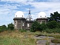
Bidston Observatory was built in 1866 using local sandstone excavated from the site. One of its functions was to determine the exact time. Up to 18 July 1969, at exactly 1:00 p.m. each day, the 'One O'Clock Gun' overlooking the River Mersey near Morpeth Dock, Birkenhead, would be fired electrically from the Observatory.[9] In 1929 the work of the observatory was merged with the University of Liverpool Tidal Institute, being taken over in 1969 by the Natural Environment Research Council. The Research Council relocated the Proudman Oceanographic Laboratory to the University of Liverpool campus in 2004.[10]
Bidston Lighthouse
| |
 | |
| Location | Bidston, Metropolitan Borough of Wirral, United Kingdom |
|---|---|
| Coordinates | 53°24′04″N 3°04′27″W / 53.401114°N 3.074285°W |
| Constructed | 1771 (first) 1873 (second) |
| Construction | sandstone tower |
| Height | 21 metres (69 ft) |
| Shape | cylindrical tower with balcony and lantern attached to 1-storey keeper’s house |
| Markings | unpainted tower |
| Operator | Bidston Lighthouse[11] |
| Light | |
| Deactivated | 1913 (second) |
| Lens | Fixed first order dioptric |
There has been a lighthouse on Bidston Hill since 1771. The first lighthouse was built by Liverpool's dockmaster William Hutchinson; it was designed to work in conjunction with Leasowe Lighthouse, forming a pair of leading lights enabling ships to avoid the sandbanks in the channel to Liverpool.[12]
Being more than two miles from the sea, Bidston depended on a breakthrough in lighthouse optics, which came in the form of the parabolic reflector, developed by Hutchinson at the signals station on Bidston Hill. The reflector at Bidston Lighthouse was thirteen-and-a-half feet in diameter (probably the largest ever made for a lighthouse)[13] and the lamp consumed a gallon of oil every four hours.[14]
The present lighthouse was built in 1873 and was equipped with a large (first order) dioptric lens with vertical condensing prisms, manufactured by Chance Brothers of Birmingham.[15] It remained operational until sunrise on 9 October 1913. (By that time Leasowe Lighthouse had already been decommissioned: the line of approach taken by ships had altered due to shifting sandbanks, rendering the leading lights ineffective).
The lighthouse at Bidston is now privately owned, and occasionally open to the public.[16] The distance it was built from the sea is a record unsurpassed by any other lighthouse, before or since.[13]
Tam O'Shanter Cottage
Tam O'Shanter Cottage is a historic cottage on the hill. It is part of Tam O'Shanter Urban Farm, a free-to-enter city farm. The cottage takes its name from the poem Tam o'Shanter by Robert Burns and is opposite Flaybrick Memorial Gardens.
Rock carvings

There is a 4+1⁄2-foot-long (1.4 m) carving of a sun goddess carved into the flat rock north-east of the Observatory, supposedly facing in the direction of the rising sun on Midsummer's Day and thought to have been carved by the Norse-Irish around 1000 AD. An ancient carving of a horse is located on bare rock to the north of the Observatory.[17]
Bidston Court
.jpg)
Robert William Hudson built a house called Bidston Court on Vyner Road South near Bidston Hill in 1891. Built entirely of wood, and based on Little Moreton Hall, it is believed to have been the inspiration for the Cecilienhof in Potsdam.[18] The house was sold in 1921 to Sir Ernest Royden and in 1928 was moved to its present site in Frankby, brick by brick, finally being completed in 1931. It was renamed Hill Bark. The original site of the house was given to Birkenhead Corporation.[19][better source needed]
Bidston Tunnels
During World War II, an air raid shelter was constructed at Bidston Hill. Today the tunnels are concealed for public safety.[20]
The Bidston Hill tunnel project was born in 1941 out of the devastating effects of the Luftwaffe blitz on Merseyside. Many infrastructure targets were hit, people killed and many more made homeless. The first week of May 1941 saw the peak of the attack, it involved 681 Luftwaffe bombers; 2,315 high explosive bombs and 119 other explosives. The raids put 69 out of 144 cargo berths out of action and inflicted 2,895 casualties, 1,741 of them fatalities.
The tunnels were built in the side of the hill allowing access at grade into two main entrances, while at the uphill end a 25m ventilation shaft was sunk, doubling up as an emergency escape via a series of steep metal ladders. The tunnels in between these ends were cut out in a familiar gridiron layout, with four long perpendicular tunnels fed at both ends from the two main entrances, and eleven cross tunnels. Toilets, a canteen, and a first aid post were provided either in the cross tunnels or at tunnel intersection nodes. Within this 1596 bunks and 793 seats were provided for those lucky enough to have the requisite shelter permit.
Construction began in December 1941 and was largely completed within a year, having suffered from escalating costs, geological problems, an unskilled labour force, and also paradoxically trespassers and vandalism. The original intention was that the tunnels would be 2.1m wide and 2.0m high with an arched roof, probably similar to those at Tranmere, but the surviving tunnels are considerably larger than this. Records indicate that the considerable height came about following roof trimming required in the latter stages of the project due to the softness of the rock and problems with instability after exposure to the air.
Minutes of Wirrals Civil Defence Emergency Committee in 1941 reveal that the peninsulas skilled workforce of shipbuilders, steel workers and other industries meant that it was granted almost unprecedented funds to establish two deep air raid shelters, one being in Tranmere and the other in Bidston. Built over the next two years there were 2213 bunks and 793 seats, as well as a canteen staff dormitory, toilets, medical posts and a ventilation shaft which could double as an emergency escape hatch if necessary. The work was not without incident and setbacks; the project was apparently plagued with trespassers and vandalism, and as with modern projects the cost of the work increase with the discovery of poor quality rock.
The shelter, like many of the deep shelters reluctantly approved by the Government, came too late to provide mass protection during the periods of heaviest bombing. In June 1943 the final bill for the project was in; £163;48,006 which is a considerable sum. Although the shelters were used the reducing frequency of the bombing raids meant that it never saw the levels of use it was designed for.
After the war it was used for customs and excise storage, fire brigade training, and was even considered for Cold War use but rejected due to extensive dry rot. The Borough Council visited in the 1950’s to see if they could find a use for it, but disapprovingly recorded it to be “damp, dark and featureless” and it has been sealed in recent times.
Gallery
-
 Summit and distance marker.
 -
 Bidston Windmill.
 -
 Bidston Observatory.
 -
 The former Joseph Proudman Building, demolished in 2013.


See also
References
- ^ "Natural Areas and Greenspaces: Bidston Hill". Metropolitan Borough of Wirral. Archived from the original on 9 December 2010. Retrieved 13 June 2010.
- ^ Kemble, Mike (15 July 2016). "The Wirral Hundred or The Wirral Peninsula". wirralhistory.net. Retrieved 2 November 2016.
- ^ Kemble, Mike (10 November 2015). "Bidston Village, Hall, Hill & Mill". wirralhistory.online. Retrieved 2 November 2016.
- ^ Brocklebank, Ralph T. (2003). Birkenhead: An Illustrated History. Breedon Books. p. 91. ISBN 1-85983-350-0.
- ^ a b Kemble, Mike. "Bidston: The Mill". wirralhistory.net. Retrieved 2 November 2016.
- ^ a b "Windmills". Allerton Oak. 11 December 2014. Retrieved 2 November 2016.
- ^ Bidston, C.E., "Old Ordnance Survey Map: Cheshire 13.02 (1909)", Alan Godfrey Maps
- ^ "Bidston Windmill". Friends of Bidston Hill Heritage Trail. Retrieved 13 March 2014.
- ^ "The Time Ball and the One O'clock Gun". Proudman Oceanographic Laboratory. Archived from the original on 27 September 2007. Retrieved 12 August 2007.
- ^ "Proudman Oceanographic Laboratory Annual Report, 2004-05 (page 26)" (PDF). Natural Environment Research Council. 2005. Archived from the original (PDF) on 4 January 2012. Retrieved 11 February 2012.
- ^ Bidstone Hill The Lighthouse Directory. University of North Carolina at Chapel Hill. Retrieved April 29, 2016
- ^ "Bidston Lighthouse". Proudman Oceanographic Laboratory. Archived from the original on 27 September 2007. Retrieved 12 August 2007.
- ^ a b "The French Visitor". Bidston Lighthouse. Retrieved 5 March 2019.
- ^ Robinson, John; Robinson, Diane (2007). Lighthouses of Liverpool Bay. The History Press. ISBN 978-0752442099.
- ^ "Has anyone seen our lamp?". Bidston Lighthouse. Retrieved 5 March 2019.
- ^ "Bidston Lighthouse". Retrieved 5 May 2014.
- ^ "Bidston Hill". Metropolitan Borough of Wirral. Archived from the original on 28 June 2008. Retrieved 16 July 2010.
- ^ History of Hillbark Hotel at hillbarkhotel.co.uk; retrieved 4 Sept 2018
- ^ "Bidston Court". Geograph. Retrieved 11 March 2007.
- ^ "Bidston Hill Underground Tunnels". wirralhistory.co.uk. Archived from the original on 24 October 2008. Retrieved 9 September 2008.
External links
- Map sources for Bidston Hill
- Friends of Bidston Hill
- Bidston Lighthouse
- Bidston Village, Church, Hall, Hill & Mill