
File:Konya districts.png

Size of this preview: 737 × 599 pixels. Other resolutions: 295 × 240 pixels | 590 × 480 pixels | 958 × 779 pixels.
Original file (958 × 779 pixels, file size: 56 KB, MIME type: image/png)
| This is a file from the Wikimedia Commons. Information from its description page there is shown below. Commons is a freely licensed media file repository. You can help. |
Summary
Created by Rarelibra 22:01, 1 December 2006 (UTC) for public domain use, using MapInfo Professional v8.5 and various mapping resources. Edited by One Homo Sapiens Corrected text where İ,Ş,ı,ğ,or ş occurs in name. Source: [statoids-com]. Increased font size and enhanced color differences among adjacent districts.
| Description |
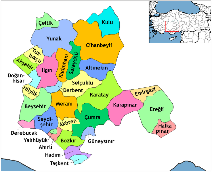
English: Map of the districts in the Province of Konya — in the Central Anatolia Region of Asian Turkey.
Svenska: Konya_Districts.png |
| Date | |
| Source | Created by Rarelibra, edited by One Homo Sapiens |
| Author | Rarelibra, One Homo Sapiens |
Licensing
| I, the copyright holder of this work, release this work into the public domain. This applies worldwide. In some countries this may not be legally possible; if so: I grant anyone the right to use this work for any purpose, without any conditions, unless such conditions are required by law. |
File history
Click on a date/time to view the file as it appeared at that time.
| Date/Time | Thumbnail | Dimensions | User | Comment | |
|---|---|---|---|---|---|
| 22:01, 1 December 2006 |  | 1,056 × 816 (46 KB) | Rarelibra | Map of the districts of Konya province in Turkey. Created by ~~~~ for public domain use, using MapInfo Professional v8.5 and various mapping resources. |
File usage
The following pages on the English Wikipedia use this file (pages on other projects are not listed):
- Ahırlı
- Akören, Konya
- Akşehir
- Altınekin
- Beyşehir
- Bozkır
- Cihanbeyli
- Derbent, Konya
- Derebucak
- Districts of Turkey
- Doğanhisar
- Emirgazi
- Ereğli, Konya
- Governor of Konya
- Güneysınır
- Hadim
- Halkapınar, Konya
- Hüyük
- Ilgın
- Kadınhanı
- Karapınar
- Karatay, Konya
- Konya
- Konya Province
- Kulu, Konya
- List of populated places in Konya Province
- Meram
- Necmettin Erbakan University
- Sarayönü
- Selçuklu
- Seydişehir
- Taşkent
- Tuzlukçu
- Yalıhüyük
- Yunak
- Çeltik
- Çumra
- User talk:Rarelibra/Maps4
Global file usage
The following other wikis use this file:
- Usage on ar.wikipedia.org
- Usage on ast.wikipedia.org
- Usage on av.wikipedia.org
- Usage on azb.wikipedia.org
- Usage on ba.wikipedia.org
- Usage on be.wikipedia.org
- Usage on ca.wikipedia.org
- Usage on ceb.wikipedia.org
- Usage on ce.wikipedia.org
- Usage on da.wikipedia.org
- Usage on de.wikipedia.org
- Konya
- Ereğli (Konya)
- Konya (Provinz)
- Diskussion:Konya
- Akşehir
- Beyşehir
- Doğanhisar
- Kulu (Konya)
- Cihanbeyli
- Vorlage:Navigationsleiste Landkreise der Provinz Konya
- Ahırlı
- Akören
- Altınekin
- Bozkır
- Çeltik
- Çumra
- Derbent (Konya)
- Derebucak
- Emirgazi
- Güneysınır
- Hadim (Konya)
- Halkapınar
- Hüyük
- Ilgın
- Kadınhanı
- Karatay (Konya)
- Meram (Konya)
- Sarayönü
- Selçuklu
- Seydişehir
- Taşkent
View more global usage of this file.