
Tacheng
Tacheng
塔城市 · شاۋەشەك قالاسى · چۆچەك شەھىرى | |
|---|---|
 "Ruins in Chuguchak" by Vasily Vereshchagin (1869) | |
.png) Location of Tacheng City (pink) in Tacheng Prefecture (yellow) and Xinjiang | |
| Country | People's Republic of China |
| Region | Xinjiang |
| Prefecture | Tacheng |
| Area | |
| • Total | 4,007 km2 (1,547 sq mi) |
| Population (2003) | |
| • Total | 160,000 |
| • Density | 40/km2 (100/sq mi) |
| Time zone | UTC+8 (China Standard) |
| Postal code | 834700 |
Tacheng (Qoqek / Sawesek) or Chöchek is a county-level city (1994 est. pop. 56,400) and the administrative seat of Tacheng Prefecture, in northern Ili Kazakh Autonomous Prefecture, Xinjiang.
The city was sometimes called Tarbaghatay or Tarbagatai (Mongolian: 'having marmots') and was once known in European languages as Chuguchak (based on its name in Mongolian language). The current Uyghur name is Qöqäk Xäĥri.
It is located in the Dzungarian Basin, some 10 km (6.2 mi) from the Sino-Kazakhstan border. Long a major center for trade with Central Asia, it is an agricultural hub. Its industries include food processing, textiles, and utilities.
The city suffered much destruction in 1865, during the fighting between the Qing forces and the Dungan and Uyghur rebels.
Border crossing
The Bakhtu border crossing into Kazakhstan is located 17 km (11 mi) from Tacheng. The checkpoint on the Kazakh side of the border is also known as Bakhty and is located 60 km (37 mi) from Makanchi in East Kazakhstan province. The border has been closed since 2009 for traffic both ways.[citation needed]
-
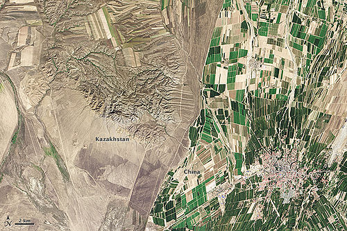 Kazakh-Chinese border near Tacheng

Climate
| Climate data for Tacheng (1971−2000) | |||||||||||||
|---|---|---|---|---|---|---|---|---|---|---|---|---|---|
| Month | Jan | Feb | Mar | Apr | May | Jun | Jul | Aug | Sep | Oct | Nov | Dec | Year |
| Mean daily maximum °C (°F) | −4.1 (24.6) |
−2.3 (27.9) |
4.1 (39.4) |
17.0 (62.6) |
23.4 (74.1) |
28.4 (83.1) |
30.8 (87.4) |
29.9 (85.8) |
24.1 (75.4) |
15.0 (59.0) |
4.3 (39.7) |
−2 (28) |
14.05 (57.29) |
| Mean daily minimum °C (°F) | −15.6 (3.9) |
−14.1 (6.6) |
−7 (19) |
3.6 (38.5) |
9.2 (48.6) |
13.6 (56.5) |
15.7 (60.3) |
14.1 (57.4) |
8.5 (47.3) |
1.9 (35.4) |
−5.6 (21.9) |
−12 (10) |
1.03 (33.85) |
| Average precipitation mm (inches) | 16.5 (0.65) |
14.4 (0.57) |
15.6 (0.61) |
32.4 (1.28) |
31.7 (1.25) |
24.5 (0.96) |
29.8 (1.17) |
16.3 (0.64) |
14.0 (0.55) |
26.9 (1.06) |
34.3 (1.35) |
25.9 (1.02) |
282.3 (11.11) |
| Average precipitation days (≥ 0.1 mm) | 8.9 | 8.5 | 9.3 | 8.2 | 9.4 | 7.9 | 8.4 | 6.3 | 6.0 | 7.5 | 10.0 | 9.7 | 100.1 |
| Source: Weather China | |||||||||||||
| Tacheng | |||||||||
|---|---|---|---|---|---|---|---|---|---|
| Chinese name | |||||||||
| Chinese | 塔城市 | ||||||||
| |||||||||
| Uyghur name | |||||||||
| Uyghur | چۆچەك شەھىرى | ||||||||
| |||||||||
| Kazakh name | |||||||||
| Kazakh | شاۋەشەك Шәуешек Şäweşek | ||||||||
References
- Khālidī, Qurbanʻali, Allen J. Frank, and Mirkasym Abdulakhatovich Usmanov. An Islamic Biographical Dictionary of the Eastern Kazakh Steppe, 1770-1912. Brill's Inner Asian library, v. 12. Leiden: Brill, 2004.
- Light, Nathan. "Qazaqs in the People's Republic of China: The Local Processes of History". Bloomington, Indiana: Indiana Center on Global Change and World Peace, Occasional Paper No. 22, June 1994. ISBN 1-881157-24-5.
- Light, Nathan. "Kazakhs of the Tarbaghatai: Ethno-History Through a Novel". The Turkish Studies Association Bulletin, 17/2 (1993): 91-102.
- Saguchi Toru. "Kazak Pastoralists on the Tarbaghatai Frontier under the Ch'ing." In: Proceedings of the International Conference on China Border Area Studies. Lin En-hsien [Lin Enxian], ed. Taipei: National Chengchi University, 1985, pp. 953–996.
- Wiens, Herold J. "Change in the Ethnography and Land Use of the Ili Valley and Region, Chinese Turkestan". Annals of the Association of American Geographers, Vol. 59, No. 4. (Dec., 1969), pp. 753–775.
External links
- Map of the City of Tacheng Template:Zh icon
- Webpage on the Bakktu border crossing in Xinjiang's Land Ports and Border Trade website