
Kalaghatagi
This article may require copy editing for grammar, style, cohesion, tone, or spelling. (March 2017) |
Kalaghatagi
ಕಲಘಟಗಿ | |
|---|---|
town/taluka | |
| Nickname: Kalagh | |
 Kalaghatagi Location in Karnataka, India | |
| Coordinates: 15°11′N 74°58′E / 15.18°N 74.97°E | |
| Country | |
| State | Karnataka |
| District | Dharwad |
| Elevation | 536 m (1,999 ft) |
| Population (2001) | |
| • Total | 14,676 |
| Languages | |
| • Official | Kannada |
| Time zone | UTC+5:30 (IST) |
| PIN | 581204 |
| Vehicle registration | KA-25, KA-63 |
| Website | http://www.kalaghatagitown.gov.in/ |
Kalaghatagi also known as Kalghatgi is a Taluka (administrive division) and Panchayat town in Dharwad district in the Indian state of Karnataka.[1]
Tourism
Kalaghatagi
Gram Devi Jatra, an ancient Taluk in the Dharwad District, is famous in Kalaghatagi.Rustoom Sab Keri , Rustoom Shaheed Darga .Benachi keri using drinking for kalghatgi Other sizeable villages in Kalaghatagi are Misrikoti and Galagi. They are famous for their large ponds. [1]
Surashettikoppa
Surashettikoppa is a village of Kalaghataghi where Shree Brahmalingeshwar God jatra is held, which is famous in Karnataka.
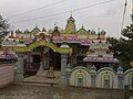
Kalghatagi Mahalakshmi temple & Durgas
Kalghatagi has a beautiful Mahalakshmi temple.Rusthoom Shaheed Durga , Satho Shaheed Darga
-
-

-
 Mahalakshmi temple


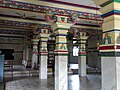
Shantinatha Basadi
Shantinatha Basadi Jain temple.

Beeravalli is an old village in Kalaghatagi. Kalameshwar Jatre is another famous place in Kalaghatagi.
Tamboor
Tamboor Basavanna Temple lies 11 km from Kalghatagi.
Tamboor is in Kalghatgi Taluk, Dharwad District in North Karnataka, India. It is about 8 km from Kalghatagi. Tamboor is a town about 11 km from Kalghatgi (via Devikoppa) NH 63, 3 km away from the main road in Karnataka state, India. The village received its name from the availability of large amounts of Copper in earlier years. "Tamra nagar" converted to tamroor and tamboor. Tamboor is located at Western Ghats, whose foliage density makes it a habitat for a few wild species like Tigers, Cheetahs, Elephants, Sarangs, Cobras, and many other wildlife. Transport: better to travel in one's own vehicle. Three daily buses and tempose traveling via Devikoppa from Kalghatgi, Hubli, Dharwad and Yellapur. Nearest places: Kalghatgi, Dharwad, Hubli and Yellapur. Other local areas of interest include Tamboor Lake, Satoo Shahid Durga, Kali River, Anashi Reserve Forest, Supa Dam. [edit]Basavanna temple
Tamboor is an important center of pilgrimage for people of the Lingayat faith. The Temple of Basavanna, one of the most revered saints of the Lingayat faith lies here. In the 12th century, the Chalukyas and Gangas ruled there. The Tamboor jathre or congregations attracts pilgrims from all over Karnataka as one of the major community or `panchamsali lingayaths' are large number devoted here visiting regularly. Tamboor (Tambur)[1] Basavanna temple[2] is situated 11 km from Kalghatgi, at the end of Devikoppa Forest.


Geography
Kalghatgi is located at 15°11′N 74°58′E / 15.18°N 74.97°E.[2] It has an average elevation of 536 metres (1758 feet). Kalghatgi is located at 28 km from Hubli and 30 km from Dharwad.The Kalghatgi town is located on National Highway 63 (India) en route from Hubli to Ankola.
Demographics
As of 2001[update] India census,[3] Kalghatgi had a population of 14,676. Males constitute 51% of the population and females 49%. Kalghatgi has an average literacy rate of 62%, higher than the national average of 59.5%: male literacy is 69%, and female literacy is 55%. In Kalghatgi, 15% of the population is under 6 years of age.
References
- ^ a b "Reports of National Panchayat Directory:". Ministry of Panchayati Raj, Government of India. Archived from the original on 7 November 2011.
{{cite web}}: Unknown parameter|deadurl=ignored (|url-status=suggested) (help) - ^ Falling Rain Genomics, Inc - Kalghatgi
- ^ "Census of India 2001: Data from the 2001 Census, including cities, villages and towns (Provisional)". Census Commission of India. Archived from the original on 2004-06-16. Retrieved 2008-11-01.