
Pawtucket, Rhode Island
City of Pawtucket | |
|---|---|
 Downtown across the Blackstone River | |
 Location of Pawtucket in Providence County, Rhode Island | |
| Country | United States |
| State | Rhode Island |
| County | Providence |
| Founded (town) | 1671 |
| Incorporated (city) | 1886 |
| Government | |
| • Type | Mayor-council |
| • Mayor | James E. Doyle |
| Area | |
| • Total | 9.00 sq mi (23.31 km2) |
| • Land | 8.7 sq mi (22.6 km2) |
| • Water | 0.3 sq mi (0.7 km2) |
| Elevation | 36 ft (11 m) |
| Population (2005) | |
| • Total | 73,742 |
| • Density | 8,437/sq mi (3,258/km2) |
| Time zone | UTC-5 (Eastern) |
| • Summer (DST) | UTC-4 (Eastern) |
| ZIP code | 02860-02862 |
| Area code | 401 |
| FIPS code | 44-54640Template:GR |
| GNIS feature ID | 1218926Template:GR |
| Website | www.pawtucketri.com |
Pawtucket is a city in Providence County, Rhode Island, United States. The population was 72,958 at the 2000 census. It is the fourth largest city in the state.
History

Pawtucket was the birthplace of the American Industrial Revolution. Slater Mill, built in 1793 by Samuel Slater on the Blackstone River falls in downtown Pawtucket, was the first commercially successful cotton-spinning mill with a fully mechanized power system in America.[1] He constructed and operated machines for producing yarn. Other manufacturers followed, transforming Pawtucket into a center for textiles, iron working and other products.
The textile business in New England declined during the Great Depression with many manufacturers closing or moving their facilities South where operations and labor were cheaper. But unlike numerous older mill towns in the region, Pawtucket retained much of its industrial base. Today, goods produced in the city include lace, non-woven and elastic woven materials, jewelry, silverware, metals and textiles. Hasbro, one of the world's largest manufacturer of toys and games, is headquartered in Pawtucket.
Originally, there were two Pawtuckets[citation needed]. Pawtucket west of the Blackstone River used to be part of nearby North Providence. East of the Blackstone River was originally settled as part of the Massachusetts town of Rehoboth.[citation needed] Once East Pawtucket (another alternate name for the area of Pawtucket east of the Blackstone) was transferred to Rhode Island in the 1860s, both sections (West and East Pawtucket) merged. It was later incorporated as a city.
Geography
Pawtucket is located at 41°52′32″N 71°22′34″W / 41.87556°N 71.37611°WTemplate:GR.
According to the United States Census Bureau, the city has a total area of 9.0 square miles (23.3 km²), of which, 8.7 square miles (22.6 km²) of it is land and 0.3 square miles (0.7 km²) of it (2.89%) is water. Pawtucket lies within three drainage basins. These include the Blackstone River, the tidal Seekonk River, and the Ten Mile River.
Demographics
As of the censusTemplate:GR of 2000, there were 72,958 people, 30,047 households, and 18,508 families residing in the city. Pawtucket was the fourth most populous of Rhode Island's 39 cities and towns. The population density was 8,351.2 people per square mile (3,223.0/km²). There were 31,819 housing units at an average density of 3,642.2/sq mi (1,405.7/km²). The racial makeup of the city was 75.39% White, 7.31% African American, 0.30% Native American, 0.85% Asian, 0.06% Pacific Islander, 10.75% from other races, and 5.34% from two or more races. Hispanic or Latino of any race were 13.90% of the population.
There were 30,047 households out of which 30.5% had children under the age of 18 living with them, 39.7% were married couples living together, 16.8% had a female householder with no husband present, and 38.4% were non-families. 32.3% of all households were made up of individuals and 12.5% had someone living alone who was 65 years of age or older. The average household size was 2.41 and the average family size was 3.07.
In the city, the population was spread out with 24.9% under the age of 18, 9.1% from 18 to 24, 31.3% from 25 to 44, 19.9% from 45 to 64, and 14.8% who were 65 years of age or older. The median age was 35 years. For every 100 females there were 90.2 males. For every 100 females age 18 and over, there were 85.9 males.
The median income for a household in the city was $31,775, and the median income for a family was $39,038. Males had a median income of $31,129 versus $23,391 for females. The per capita income for the city was $17,008. About 14.9% of families and 16.8% of the population were below the poverty line, including 24.5% of those under age 18 and 15.2% of those age 65 or over.
According to the 2000 census, 20.6% of Pawtucket residents are French or French-Canadian.[2] Like nearby cities Providence, RI; East Providence, RI; Fall River, MA; & New Bedford, MA; Pawtucket hosts a significant population from across the Portuguese Empire (11.6%)[2] plus an extremely significant Cape Verdean population. The segment from Cape Verde Islands was featured in this Zip Code USA article from National Geographic magazine.
Pawtucket is also one of the few areas of the United States with a significant Liberian population, mostly refugees from Charles Taylor's regime. Rhode Island has the highest per capita Liberian population in the country. [citation needed] Pawtucket has a very high concentration of West Africans.
Transportation
Amtrak's Northeast Corridor and the MBTA's Providence/Stoughton Line run through Pawtucket, though there is no stop for either in the city. Train service at the Pawtucket/Central Falls train station terminated in 1959. Recently there have been discussions to have the "T" stop in Pawtucket at the old train station (which would be substantially refurbished) or at a platform elsewhere on the line. Commuters can catch the "T" at the South Attleboro stop, located off Newport Avenue just over the state line. The MBTA operates a layover facility in Pawtucket for trains on the Providence/Stoughton Line. It is not a station, but simply a place where the trains are kept overnight. The closest Amtrak station to Pawtucket is Providence Station.
Public bus transportation is available in the city. RIPTA operates a hub in downtown Pawtucket with routes to various parts of the city and to parts of nearby towns. Riders can also access RIPTA buses to Providence at the downtown hub, or on the Smithfield Avenue (#53) or Pawtucket Avenue (#99) routes. At Kennedy Plaza, Providence's hub, riders can access routes to most parts of the state.
Highways and roads
Interstate 95 and U.S. 1 also traverse the western part of Pawtucket. Some of the slowest posted speeds on I-95 are in the city due to the "S-curves" near downtown. In order to preserve certain buildings in the city, planners snaked I-95 creating sharp bends in the highway.
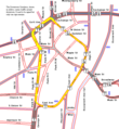
Downtown Circulator
Pawtucket's Downtown Circulator was a one-way loop through downtown; it is similar to British concepts of ring roads. A similar concept was also tried in Providence.
The circulator used East Avenue, High Street, Summer Street, Goff Avenue, Dexter Street and Park Place West. Each half of the Circulator carried one direction of U.S. 1; sections also carried westbound RI 15 and northbound RI 114. It was signed with a big 'C' on overhead signs.
The circulator is no longer signed, though the road configuration remains. Providence's Downtown Ring Roads have suffered a similar fate.
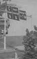
-
 The only remaining sign
 -
 Map
Map -
 Former overhead signs, with C sign at left


Culture
The City of Pawtucket hired Researcher Ann Galligan, of Northeastern University, to create an arts and cultural plan. Allowing the city to become more proactive in retaining and attracting artists will enable city officials to allocate resources more effectively to meet the needs of Pawtucket's growing artist community.
Pawtucket is becoming known as a center for arts and culture. This reposted 2004 NY Times article describes the city's efforts to attract artists as well as its continuing problems with red tape. The 2008 documentary Pawtucket Rising also chronicled the influx of artists and cultural activities into previously blighted areas of the city.
Each September, the city, in conjunction with members of the Pawtucket Arts Collaborative, produces an annual Arts Festival. The city also hosts Riversing, an independently-produced, day-long musical event.
The American-French Genealogical Society was founded in Pawtucket in 1978.[3]
Education
Public Schools
Public education in Pawtucket is directed by the Pawtucket School Department and contains these schools: [4]
Senior High Schools
- William E. Tolman
- Charles E. Shea
- Jacqueline M. Walsh School for the Performing & Visual Arts
- Blackstone Academy Charter School
Junior High Schools
- Samuel Slater
- Joseph Jenks
- Lyman B. Goff
Elementary Schools
- Elizabeth Baldwin
- M. Virginia Cunningham
- Flora S. Curtis
- Curvin McCabe
- Fallon Memorial
- Nathanael Greene
- Agnes E. Little
- Potter Burns
- Francis J. Varieur
- Henry J. Winters
Catholic Schools
The Quality Hill section of Pawtucket is home to St. Raphael Academy. It is a private college preparatory school founded on the basis of St. John the Baptist de la Salle. "Saints" is a small school consisting of roughly 500 students with a student to teacher ratio of about 15:2. The "Saints and Lady Saints" are very successful in sports including baseball, football, basketball, and softball. St. Raphael Academy is a rival of William E. Tolman. They took part in a Thanksgiving Day football game that was played in McCoy Stadium for over 70 years. This game is no longer played, as William E. Tolman now competes annually against its fellow Pawtucket public high school Charles E. Shea, rather than against St. Raphael Academy, a private Catholic high school.
Pawtucket is also home to Bishop Keough High School, a small all-girls catholic high school located in the Fairlawn neighborhood.
The city also has three catholic elementary schools: St. Cecilia School, St. Teresa School and Woodlawn Catholic Regional School.
Sports

Pawtucket is home to the Pawtucket Red Sox, the AAA affiliate/Minor League team of the Boston Red Sox and owned by Ben Mondor. The longest professional baseball game in history was played at McCoy Stadium. Pawtucket has a history of professional baseball dating back to 1892, including the Pawtucket Indians.
In 1934 the Narragansett Race Track opened for Thoroughbred horse racing. Until its closure in 1978, the track hosted several important races that drew some of the top horses from around the United States including Hall of Famers War Admiral, Seabiscuit, and Gun Bow.
Parks and recreation
Slater Memorial Park has full recreational facilities including, tennis courts and picnic areas.
In popular culture
- In the 1999 film Outside Providence, the movie's main character, Tim Dunphy, grew up in Pawtucket (a city just outside Providence). Many different Pawtucket locations are seen in the movie, including the police station.
- American Buffalo, a 1996 film, was filmed in Pawtucket.
- Pawtucket has been frequently referenced in the cartoon series Family Guy, specifically the "Pawtucket Brewery" and the character "Pawtucket Pat", though no brewery exists in real Pawtucket. The toy company that Peter Griffin worked for early in the series was called the Happy-Go-Lucky Toy Co, the name a loose parody based on the name of the Hasbro toy company based in Pawtucket.
- In December 1993, a character on the short-lived NBC sitcom "Nurses" called Pawtucket a pit. Then-mayor Bob Metivier appeared on the show months later in a cameo looking for an apology.
- The indoor pool at Tolman High School was used for the movie "Mermaids."
Sister city
![]() Pawtucket is twinned with Belper, Derbyshire, a town in England where Samuel Slater had been apprenticed to Jedediah Strutt, learning the secrets of Richard Arkwright's Water Frame (and is sometimes known in that area as "Slater the traitor").
Pawtucket is twinned with Belper, Derbyshire, a town in England where Samuel Slater had been apprenticed to Jedediah Strutt, learning the secrets of Richard Arkwright's Water Frame (and is sometimes known in that area as "Slater the traitor").
Notable residents

- Silas Lopes, 1 inch sauce
- Willard L. Beaulac, diplomat
- Don Bousquet, cartoonist
- Jon B., singer and songwriter
- Ernie Calverley, basketball player
- Wendy Carlos, composer and electronic musician
- Aram Chobanian, cardiologist
- Ruth Clifford, silent film star
- Mike Cole, actor
- Jim Connors, radio personality
- Thomas Gardiner Corcoran, presidential advisor
- Michael Corrente, independent film director
- Alice Drummond, actress
- Jack Duffy, actor
- Joseph L. Fisher, congressman
- Joel Garreau, journalist, editor and author
- David Hartman, television personality
- Raymond Hood, architect
- Galway Kinnell, poet
- John LaRose, baseball player
- Irving R. Levine, journalist and foreign correspondent
- Kevin Lima, film director
- Peter Manfredo, boxer
- Rosario Mazzeo, clarinetist
- Louis Monast, congressman
- Morris Nathanson, architect
- Chet Nichols, Jr., baseball player
- Sam Patch, daredevil
- Laika, Homebound, band
- Gerry Philbin, football player
- Red Pollard, Jockey
- David Rawlings, musician
- Charles Reilly, novelist
- Al Rockoff, photojournalist
- Ken Ryan, baseball player
- Walter Schroder, author and lecturer
- Samuel Slater, industrialist
- Hank Soar, football player, baseball umpire
- Samuel Starkweather, politician
- Minton Warren, scholar
- Tim White, professional wrestling referee
- Gary Whitehead, poet and painter
- Jeff Xavier, basketball player
See also
- Pawtucket Rising (2008 Documentary on Pawtucket)
- Fire Station No. 4
- Hasbro
- Main Street Bridge
- Pawtucket/Central Falls
- Pawtucket City Hall
- Pawtucket Congregational Church
- Pawtucket Elks Lodge Building
- Pawtucket Post Office
- Pawtucket Times Building
- Pawtucket West High School
- Riverside Cemetery
- Shea High School
- St. John the Baptist Church
- Saint Paul's Church
- St. Raphael Academy
- South Street Historic District
- Trinity Church
- Joseph Jenckes
References
- ^ [http://www.nps.gov/blac/historyculture/index.htm Blackstone River Valley National Heritage Corridor - History & Culture (U.S. National Park Service)
- ^ a b http://www.pawtucketri.com/about/2000census.pdf
- ^ American-French Genealogical Society: Home Page
- ^ "Pawtucket School Department District Homepage". Retrieved 2008-08-19.
External links
- Providence Journal video of the Blackstone River
- City of Pawtucket, Rhode Island
- Pawtucket Public Library
- Pawtucket Arts Collaborative
- PADS: Pawtucket Alliance for Downtown Success
- Pawtucket Arts Festival
- Slater Mill
- Pawtucket Online
- Urban Smart Growth/Hope Webbing Mill
- The Pawtucket Times
- Memorial Hospital of Rhode Island
- PawtucketRI.net Website
- AllPawtucket.com Website
- What Was Pawtucket Like 100 Years Ago?
- The Sandra Feinstein-Gamm Theatre
Municipalities and communities of Providence County, Rhode Island, United States | ||
|---|---|---|
| Cities |  | |
| Towns | ||
| CDPs | ||
| Other villages | ||