
Estréelles
Estréelles | |
|---|---|
 The town hall of Estréelles | |
.svg) Coat of arms | |
Location of Estréelles  | |
 Estréelles  Estréelles | |
| Coordinates: 50°29′59″N 1°47′05″E / 50.4997°N 1.7847°E | |
| Country | France |
| Region | Hauts-de-France |
| Department | Pas-de-Calais |
| Arrondissement | Montreuil |
| Canton | Berck |
| Intercommunality | CA Deux Baies en Montreuillois |
| Government | |
| • Mayor | Dominique Szczepanski |
| Area 1 | 3.18 km2 (1.23 sq mi) |
| Population (2021)[1] | 345 |
| • Density | 110/km2 (280/sq mi) |
| Time zone | UTC+01:00 (CET) |
| • Summer (DST) | UTC+02:00 (CEST) |
| INSEE/Postal code | 62315 /62170 |
| Elevation | 5–79 m (16–259 ft) (avg. 10 m or 33 ft) |
| 1 French Land Register data, which excludes lakes, ponds, glaciers > 1 km2 (0.386 sq mi or 247 acres) and river estuaries. | |
Estréelles is a commune in the Pas-de-Calais department in the Hauts-de-France region of France.
Geography
A village situated some 3 miles (5 km) northeast of Montreuil-sur-Mer at the D127 road.
Population
| Year | 1962 | 1968 | 1975 | 1982 | 1990 | 1999 |
|---|---|---|---|---|---|---|
| Population | 157 | 164 | 163 | 176 | 229 | 269 |
| From the year 1962 on: No double counting—residents of multiple communes (e.g. students and military personnel) are counted only once. | ||||||
Places of interest
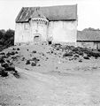
- The seventeenth century church of Saint Omer
- The former Protestant church of the late 15th century, which was demolished in 1970. Foundations of chequered sandstone and carved flint are all that remain.
-
 The Protestant church, known as "The fort".
 -
 Front view
 -
 Side view
 -
 From the valley
 -
 During demolition, in 1970
 -
 An artist's impression
 -
 Newspaper article
 -
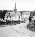 The village church


See also
References
- ^ "Populations légales 2021" (in French). The National Institute of Statistics and Economic Studies. 28 December 2023.
Wikimedia Commons has media related to Estréelles.
| International | |
|---|---|
| National | |
This Pas-de-Calais geographical article is a stub. You can help Wikipedia by expanding it. |