
Longfossé
- العربية
- Asturianu
- 閩南語 / Bân-lâm-gú
- Brezhoneg
- Català
- Cebuano
- Deutsch
- Eesti
- Español
- Euskara
- Français
- Bahasa Indonesia
- Italiano
- Қазақша
- Kurdî
- Ladin
- Latina
- Magyar
- Malagasy
- مصرى
- Bahasa Melayu
- Nederlands
- Нохчийн
- Occitan
- Picard
- Piemontèis
- Polski
- Português
- Română
- Simple English
- Slovenčina
- Svenska
- Татарча / tatarça
- Українська
- Vèneto
- Tiếng Việt
- Winaray
- Zazaki
- 中文
From Wikipedia, the free encyclopedia
This is an old revision of this page, as edited by Markussep (talk | contribs) at 08:26, 14 May 2020 (rm unspecific archived external link). The present address (URL) is a permanent link to this revision, which may differ significantly from the current revision.
Commune in Hauts-de-France, France
Longfossé | |
|---|---|
 The town hall and school of Longfossé | |
 Coat of arms | |
Location of Longfossé  | |
 Longfossé  Longfossé | |
| Coordinates: 50°39′10″N 1°48′23″E / 50.6528°N 1.8064°E / 50.6528; 1.8064 | |
| Country | France |
| Region | Hauts-de-France |
| Department | Pas-de-Calais |
| Arrondissement | Boulogne-sur-Mer |
| Canton | Desvres |
| Intercommunality | CC Desvres-Samer |
| Government | |
| • Mayor (2008–2014) | Jean-Claude Pruvost |
| Area 1 | 10.22 km2 (3.95 sq mi) |
| Population (2021)[1] | 1,506 |
| • Density | 150/km2 (380/sq mi) |
| Time zone | UTC+01:00 (CET) |
| • Summer (DST) | UTC+02:00 (CEST) |
| INSEE/Postal code | 62524 /62240 |
| Elevation | 39–207 m (128–679 ft) (avg. 91 m or 299 ft) |
| 1 French Land Register data, which excludes lakes, ponds, glaciers > 1 km2 (0.386 sq mi or 247 acres) and river estuaries. | |
Longfossé is a commune in the Pas-de-Calais department in the Hauts-de-France region of France.
Geography
Longfossé is situated some 9 miles (14 km) southeast of Boulogne, at the junction of the D204 and D215 roads..
Population
| 1962 | 1968 | 1975 | 1982 | 1990 | 1999 | 2006 |
|---|---|---|---|---|---|---|
| 1103 | 1151 | 1148 | 1160 | 1218 | 1226 | 1275 |
| Census count starting from 1962: Population without duplicates | ||||||
Places of interest
- The church of St.Pierre, dating from the seventeenth century.
- An eighteenth-century manorhouse.
Gallery
-
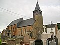 St.Pierre Church
 -
 A statue of Jesus in the town


See also
References
- ^ "Populations légales 2021". The National Institute of Statistics and Economic Studies. 28 December 2023.
Wikimedia Commons has media related to Longfossé.
| National | |
|---|---|
| Geographic | |
This Pas-de-Calais geographical article is a stub. You can help Wikipedia by expanding it. |
Retrieved from "https://en.wikipedia.org/w/index.php?title=Longfossé&oldid=956608294"
Hidden categories:
- Articles with short description
- Short description is different from Wikidata
- Coordinates on Wikidata
- Pages using infobox settlement with image map1 but not image map
- Commons category link from Wikidata
- Articles with BNF identifiers
- Articles with BNFdata identifiers
- Articles with MusicBrainz area identifiers
- All stub articles
- Pages using the Kartographer extension